Doolin Cycle Hub - Loop 2

Mostrar el mapaNavegarImprimirDescargarEditar
Publicidad
Publicidad
37,3 km
450 m
02h29
Medium

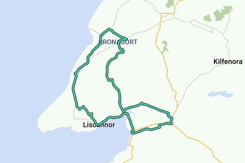
Ver en mapa interactivo

Información de la ruta

97 visitas | Pública

Último verificado: 25 octubre 2024

Descripción por el autor

More information on Openstreetmap.
Inspired by OSM.

Publicidad

Origen de la ruta

Descripción de la ruta

Región

Estadísticas

Nivel de dificultad: Medium (70/100)

Longitud: 37,3 km

Duración: 02h29


Ascenso total: 450 m

Pendiente máxima: 4,8 %

Pendiente media: 1,2 %

Ascenso neto: 1 m

Descenso total: 449 m

Carreteras y subsuelo

Carreteras asfaltadas: 37,3 km (100 %)

Adoquines: 0 m (0 %)

Carril bici: 0 m (0 %)

Escenario

Carreteras sin coches: 0 m (0 %)

Contaminación acústica

Cantidad de trafico


Espacio natural

Área urbana

Zona rica en agua

Características

    Temas

      Grupos

        Inicio y final de la ruta

        Dirección más cercana al inicio: R459, Clare, Ireland
        Dirección más cercana al final: R479, Clare, Ireland

        Navegar al punto de partida

        Lugares de interés

        1. Doolin

          0 · Pueblo
          Doolin is a coastal village in County Clare, Ireland, on the Atlantic coast. It is southwest of …
          Wikipedia
        2. Aille River

          0 · River
          The Aille River in County Clare in Ireland rises on the slopes of Slieve Elva in the Burren. It …
          Wikipedia
        3. Doonagore Castle

          0 · Castillo
          Doonagore Castle is a round 16th-century tower house with a small walled enclosure located about 1 …
          Wikipedia
        4. Thrift or Beachwort

          0 · Vegetation
          The vegetation is maritime and alpine. Here beach herb on the slope. If you look closely, you will …
          Blauwkruikje
        5. O'Brien's Tower

          0 · Structure
          O'Brien's Tower marks the highest point of the Cliffs of Moher, a very popular tourist destination …
          Wikipedia
        6. Parking Cliffs of Moher

          0 · Parking
          The size of this parking indicates the importance of this spot.
          Dromos
        7. Cliffs of Moher Visitor's Centre

          0 · Visitingcenter
          In the 1990s, County Clare Council started development plans to allow visitors to see the cliffs …
          Blauwkruikje
        8. Cliffs of Moher

          0 · Atracción turística
          The Cliffs of Moher are sea cliffs located at the southwestern edge of the Burren region in …
          Wikipedia
        9. Kalksteenschutting

          0 · Pad
          Blauwkruikje
        10. Burren and Cliffs of Moher Geopark

          0 · POI


          The Burren and Cliffs of Moher Geopark is an internationally designated area of geological …
          Wikipedia
        11. Cliffs of Moher

          0 · Cliff coast
          The cliff coast and O' Brien's Tower from the left cliff path.
          Blauwkruikje
        12. St Brigid's Well

          0 · Source
          Saint Brigid of Kildare or Brigid of Ireland is one of Ireland's patron saints, along with …
          Wikipedia
        13. Liscannor

          0 · Municipality
          Liscannor parish is a parish in County Clare and part of the Kilfenora Deanery of the Roman …
          Wikipedia
        14. Liscannor

          0 · Pueblo
          Lying on the west coast of Ireland, on Liscannor Bay, the village is located on the R478 road …
          Wikipedia
        15. Kirche von Kilmacreehy

          0 · Archäologischer platz
          Wikipedia
        16. Kilmacrehy

          0 · Municipality
          Kilmacrehy, sometimes also Kilmacreehy, is a civil parish in County Clare, Ireland. The ruins of …
          Wikipedia
        17. Lahinch Golf Club

          0 · Structure
          Lahinch Golf Club is a links golf course in western Ireland, in the town of Lahinch on the …
          Wikipedia
        18. Lehinch

          0 · Municipality
          Lehinch is a townland in the barony of Ormond Lower, County Tipperary in Ireland. It is located …
          Wikipedia
        19. Lahinch

          0 · Pueblo
          Lahinch or Lehinch is a small town on Liscannor Bay, on the northwest coast of County Clare, …
          Wikipedia
        20. Kilmanaheen

          0 · Municipality
          Kilmanaheen is named after Saint Mainchín, the patron saint of the diocese of Limerick.
          It is part …
          Wikipedia
        21. Ennistymon House

          0 · Structure
          Ennistymon House was a former country house in the village of Ennistymon, County Clare in …
          Wikipedia
        22. Ennistymon

          0 · Pueblo
          Ennistymon or Ennistimon is a country market town in County Clare, near the west coast of …
          Wikipedia
        23. Ennistymon

          0 · Municipality
          Ennistymon parish is a parish in County Clare and part of the Kilfenora Deanery of the Roman …
          Wikipedia
        24. C.B.S. Secondary School Ennistymon

          0 · School
          CBS Ennistymon is an all-boys secondary school located in Ennistymon, County Clare. It was founded …
          Wikipedia
        25. Dealagh River

          0 · River
          The Dealagh is a river of County Clare, western Ireland. It converges with the Inagh River at …
          Wikipedia
        26. Killaspuglonane

          0 · Municipality
          Killaspuglonane in the part of the historical barony of Corcomroe.
          It is 2.75 miles northwest of …
          Wikipedia
        27. Dough Castle

          0 · Castle
          Dough Castle is a ruined tower house at Lahinch in County Clare, western Ireland. It was …
          Wikipedia

        Productos interesantes para tu viaje

        Publicidad

        Comentarios

        Actividades

        En la zona

        Rutas en la zona

        Alojamiento en la zona

        Servicios en la zona

        Doolin
        Aille River
        Doonagore Castle
        Thrift or Beachwort
        O'Brien's Tower
        Parking Cliffs of Moher
        Cliffs of Moher Visitor's Centre
        Cliffs of Moher
        Kalksteenschutting
        Burren and Cliffs of Moher Geopark
        Cliffs of Moher
        St Brigid's Well
        Liscannor
        Liscannor
        Kirche von Kilmacreehy
        Kilmacrehy
        Lahinch Golf Club
        Lehinch
        Lahinch
        Kilmanaheen
        Ennistymon House
        Ennistymon
        Ennistymon
        C.B.S. Secondary School Ennistymon
        Dealagh River
        Killaspuglonane
        Dough Castle
        0 km2 km4 km6 km8 km10 km12 km14 km16 km18 km20 km22 km24 km26 km28 km30 km32 km34 km36 km37 km2 m189 m
        PLUS
        500 m

        © 2006-2025 RouteYou - www.routeyou.com