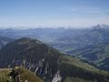
This pleasant and easy 50-kilometre loop leads along smooth cycle paths and quiet side roads from the village of Fieberbrunn in the Pillerseetal Valley via St. Johann to St. Ulrich am Pillersee and back again. The roughly 700 vertical metres of climbing pose no real challenge and are evenly distributed along the route. Along the way there are also plenty of huts and restaurants as well as charging points for e-bikes and even the chance to cool off with a dip in the refreshing waters of the Pillersee lake.
From the centre of Fieberbrunn, follow the main road for about 200 metres in an easterly direction and then turn left towards "Schönau-Pertrach". On a narrow asphalt road, the trail climbs about 60 metres in altitude to the Fieberbrunn hamlet of Pertrach. Now follow the mountain bike route "17 Buchensteinwandrunde" to Mühlau. When you reach the main road on the left, cycle along it in a westerly direction for only about 100 metres and then immediately turn right onto the cycle path "18 Kalksteinrunde". Stay on this route, which is always slightly elevated above the valley, until you reach the small hamlet of Reitham. Turn right here and cycle along side roads, past the small airfield to the north and on via Oberhofen, Niederhofen to Moosen. Here you take the main road and the cycle path towards Kirchdorf, later along the banks of the Großache river towards Erpfendorf. About 21 kilometres after Kirchdorf turn right onto the cycle path to Erpfendorf, pass under the main road and continue to the centre of Erpfendorf. From here, follow the cycle path signs to Waidring. In the village centre turn right onto the road to St. Ulrich am Pillersee. After two kilometres, a small bridge is crossed and the route continues on a cycle path before crossing the road again and a roadway leads to the Pillersee. Now follow the cycle path signs always to "St. Ulrich" and later to "Hochfilzen". The flat landscape is crossed and in a south-easterly direction the route continues on an asphalt road towards the Wiesensee lake. After about one kilometre, turn left and immediately right again, parallel to the road, on a forest path past the Wiesensee lake to the Hochfilzen hamlet of Warming. Here, between the farms of "Hörl" and "Glaagut", turn right onto cycle route 17 "Buchensteinwandrunde" and follow it back to Fieberbrunn.
Source: Visit Tirol
Vous avez remarqué quelque chose sur cet itinéraire ?Ajouter rapport
Parcourir l'itinéraire dans...
![]() Application RouteYou Ouvrez
Application RouteYou Ouvrez
Vous ne voulez plus voir cette publicité ?
→ Actualiser maintenant
![]()
Veuillez patienter, la navigation est en cours de préparation.
Vous pouvez maintenant naviguer. Bonne route !
Le traitement de la demande a échoué. Veuillez réessayer.
Vous ne voulez plus voir cette publicité ?
→ Actualiser maintenant
![]()
Veuillez patienter, votre téléchargement est en cours de préparation.
Votre téléchargement est prêt. Bonne route !
Le traitement de la demande a échoué. Veuillez réessayer.
Vous ne voulez plus voir cette publicité ?
→ Actualiser maintenant
![]()
Veuillez patienter, votre impression est en cours de préparation.
Votre impression est prête à être téléchargée. Bonne route !
Le traitement de la demande a échoué. Veuillez réessayer.
<iframe src="https://plugin.routeyou.com/routeviewer/free/?language=fr&params.route.id=15263159&params.language=en" width="100%" height="600" frameborder="0" allowfullscreen></iframe>
<p><a class="routeYou_embed" href="https://app.routeyou.com/en-at/route/view/15263159?utm_source=embed&utm_medium=article&utm_campaign=routeshare&navigation=external" title="Pillerseetal Valley - RouteYou" target="_blank"><img src="https://image.routeyou.com/embed/route/960x670/15263159-en@2x.png" style="width: 100%; height: auto;" alt="Pillerseetal Valley"></a></p>
Commentaires supplémentaires :
Cette fonctionnalité est exclusivement disponible pour les abonnés RouteYou PREMIUM.
Essayez 1 mois gratuit maintenant et découvrez la différence ! Nous n'exigeons aucune donnée de paiement et le service s'arrête automatiquement après votre période d'essai d'un mois.
© 2006-2026 RouteYou - www.routeyou.com