363 vues | Public | allemand • français • néerlandais
 Azure
AzureNo, Sint-Niklaas is not celebrated in Weerde (unless by new residents). The new residents will also soon experience the difference between Sint-Niklaas and Sint-Maarten at their front door. Children come to sing for some sweets or other goodies. See http://www.nieuwsblad.be/article/detail.aspx?articleid=BLPVA_20111111_001 and http://nl.wikipedia.org/wiki/Sint-Maarten_%28feest%29
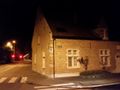
This Sint-Maartenloop is a night run that visits the busy roads between Mechelen and Vilvoorde center: Between 11:30 am and 5 am there is hardly any traffic on those busy Provincial roads and in the center, the ideal time to walk in the public lighting (visibility OK) a loop that is truly exceptional.
And Halloween? No, he clearly has to lose out for this Sint Maarten night run!
There are 5 churches:
1; The GPX departs from Sint-Martinus ('Sint-Maarten'') in Weerde (but of course you can start anywhere!);
2; Round around the St. Rumbold's Cathedral in Mechelen;
3; passage along the Sint-Jan-Berchmanskerk in Mechelen (Brusselsesteenweg);
4; passage past St. Peter's Church in Zemst;
5; Round around the Church of Our Lady of Good Hope in Vilvoorde.
A lot of relics are passed at these and other locations (see https://inventaris.onroerenderfgoed.be/dibe/relicten?naam=&provincie=20001&gemeente=23088&deelgemeente_naam=&straat_naam=Mechelsesteenweg&typologie=&context=&datering=&stijl=&persoon_naam=&zoeken=zoeken )
To illustrate all this, almost 150 night shots and panorama montages have been made especially for this loop and incorporated into the POIs.
If a looplus of 28km is a bit too much for you, do it by bike, or split it into parts. For example, you can visit Mechelen or Vilvoorde or Zemst, and with the new APP for smartphones you can find here: https://www.routeyou.com/nl-be/page/view/463/mobiel-met-routeyou.nl , or this latest one: https://www.routeyou.com/nl-be/page/view/554/guideyou.nl , where you can also experience all POIs instantly (online) or also use them in offline modis if you do not have mobile internet.
This loop has been designed so that as much as possible the 'new' roads in the north are used, and as many historical 'old' roads as possible in the southern direction.
In a northerly direction you have the Hendrik-I-lei and the Mechelsesteenweg (Vilvoorde), the Zenneweg, Weverstraat, Vredelaan, Heidestraat and Brusselsesteenweg (Zemst and Mechelen).
In the south you have the Oude Brusselsesteenweg and the Zemstbaan (Mechelen), Brusselsesteenweg, Oude Mechelsesteenweg and the Lange Molensstraat (Vilvoorde).
In the northernmost point Mechelen is visited via the Bruul past the historic Town Hall, the market and the Sint-Romboutstoren, and further via the IJzerenleen, Hoogstraat and Brusselpoort out of the city.
In the southern point of Vilvoorde, the 'Paardenmarkt' and the town hall are visited via the Mechelsestraat, and via the Lange Molensstraat around the O.-L.-V.Van-Goede-Hoop church and the Heldenplein (Paardemnomument Rik Poot) return northwards along the central axis Portaalsplein -JB Nowélei.
During the day, these roads are busy. At night in the early hours you will not be bothered by this at all. Then it's walking/walking/cycling like you're in another world. You pay attention to those things that are hidden behind the daily noise. https://www.facebook.com/photo.php?fbid=491712670943704&set=pb.286283181486655.-2207520000.1388149243.&type=3&theater
Vous avez remarqué quelque chose sur cet itinéraire ?Ajouter rapport
Parcourir l'itinéraire dans...
![]() Application RouteYou Ouvrez
Application RouteYou Ouvrez
Vous ne voulez plus voir cette publicité ?
→ Actualiser maintenant
![]()
Veuillez patienter, la navigation est en cours de préparation.
Vous pouvez maintenant naviguer. Bonne route !
Le traitement de la demande a échoué. Veuillez réessayer.
Vous ne voulez plus voir cette publicité ?
→ Actualiser maintenant
![]()
Veuillez patienter, votre téléchargement est en cours de préparation.
Votre téléchargement est prêt. Bonne route !
Le traitement de la demande a échoué. Veuillez réessayer.
Vous ne voulez plus voir cette publicité ?
→ Actualiser maintenant
![]()
Veuillez patienter, votre impression est en cours de préparation.
Votre impression est prête à être téléchargée. Bonne route !
Le traitement de la demande a échoué. Veuillez réessayer.
<iframe src="https://plugin.routeyou.com/routeviewer/free/?language=fr&params.route.id=1273604&params.language=en" width="100%" height="600" frameborder="0" allowfullscreen></iframe>
<p><a class="routeYou_embed" href="https://app.routeyou.com/en-be/route/view/1273604?utm_source=embed&utm_medium=article&utm_campaign=routeshare&navigation=external" title="Sint Maarten Night Run (28,5km) - RouteYou" target="_blank"><img src="https://image.routeyou.com/embed/route/960x670/1273604-en@2x.png" style="width: 100%; height: auto;" alt="Sint Maarten Night Run (28,5km)"></a></p>
Commentaires supplémentaires :
Cette fonctionnalité est exclusivement disponible pour les abonnés RouteYou PREMIUM.
Essayez 1 mois gratuit maintenant et découvrez la différence ! Nous n'exigeons aucune donnée de paiement et le service s'arrête automatiquement après votre période d'essai d'un mois.
© 2006-2025 RouteYou - www.routeyou.com