Grâce à notre partenaire Pasar vzw, vous pouvez accéder gratuitement à cet itinéraire - et découvrir RouteYou PLUS.
Découvrez tous les avantages Azure
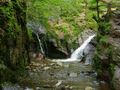
AzureThe Ninglinspo is a tributary of the Amblève near the Liège commune of Nonceveux near Remouchamps in the commune of Aywaille. It forms the lower course of the Hornay which has its source near the town of Vertbuisson in the commune of Theux.
The Ninglinspo is the only mountain river in Belgium. It crosses an area classified since 1949. It is a place that purges its beauty of its wildness. Probably one of the most attractive places in Upper Belgium. The nature is exceptional, there is the possibility of swimming and you can enjoy beautiful views. The course of the Ninglinspo is about 3.5 km long, has an average decomposition of 7.5% and makes up a height difference of 200 meters. Source: Wikipedia
What could be more fun for children and hikers to admire its sculpted baths and nature in a playful way, to the rhythm of this beautiful mountain river? The place is on the list of special Walloon heritage monuments. Several marked walks start in the parking lot and lead through bridges and forest paths in front of beautiful viewpoints. Walk number 21 follows the Ninglinspo to the top. From the car park, follow the blue rectangle. On the way, you will come across baths called "Cascade de la chaudière" (185m), "Bain des Naïades" (215m), "Bain d'Hermès" (220m), "Bain de la Lotter" (295m), "Bain du Cerf" (305m), "Bain de Diane" (310m) or "Bain de Venus" (330m)! An unforgettable trip! Source: www.ourthe-ambleve.be
Geological hiking guide of the region: http://aow.kuleuven.be/geologie/ninglinspo/
Signage: blue rectangle 21
Start/finish: GPS Coordinates: 50.468609, 5.74354.
Parking: Auberge du Ninglinspo, Sedoz 5,
4920 Sougné-Remouchamps (Aywaille)
Vous avez remarqué quelque chose sur cet itinéraire ?Ajouter rapport
Parcourir l'itinéraire dans...
![]() Application RouteYou Ouvrez
Application RouteYou Ouvrez
![]()
Veuillez patienter, votre impression est en cours de préparation.
Votre impression est prête à être téléchargée. Bonne route !
Le traitement de la demande a échoué. Veuillez réessayer.
<iframe src="https://plugin.routeyou.com/routeviewer/free/?language=fr&params.route.id=13711073&params.language=en" width="100%" height="600" frameborder="0" allowfullscreen></iframe>
<p><a class="routeYou_embed" href="https://app.routeyou.com/en-be/route/view/13711073?utm_source=embed&utm_medium=article&utm_campaign=routeshare&navigation=external" title="Autumn walk along the Ninglinspo (Aywaille) - RouteYou" target="_blank"><img src="https://image.routeyou.com/embed/route/960x670/13711073-en@2x.png" style="width: 100%; height: auto;" alt="Autumn walk along the Ninglinspo (Aywaille)"></a></p>
Commentaires supplémentaires :
Cette fonctionnalité est exclusivement disponible pour les abonnés RouteYou PREMIUM.
Essayez 1 mois gratuit maintenant et découvrez la différence ! Nous n'exigeons aucune donnée de paiement et le service s'arrête automatiquement après votre période d'essai d'un mois.
© 2006-2026 RouteYou - www.routeyou.com