Grâce à notre partenaire Pasar vzw, vous pouvez accéder gratuitement à cet itinéraire - et découvrir RouteYou PLUS.
Découvrez tous les avantages1572 vues | Public | allemand • français • néerlandais
Parking in Afsnee Dorp, where bike storage is also provided. Public transport: De Lijn numbers 34 and 35 - stop Afsnee Dorp from station Gent Sint-Pieters.
Introduction
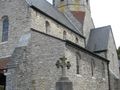
The walk starts in the picturesque village of Afsnee at the foot ferry to the Drie Leien. The focal point is the Sint-Jan De Doperkerk, a Romanesque church from the 12th century. At both the beginning and the end of the walk, you pass through the kouter of Afsnee. These dry, slightly elevated sandy areas can be considered part of the village's old permanent farmland. It is unfortunate about the noise from the E40, which was constructed right through the nature reserve. Over a "floating" footpath, hanging under the motorway, you cross the Leie. You follow the river for one and a half kilometers. Along the way, you have a splendid view of the village center of Sint-Martens-Latem with its white church and the Tempelhof, one of the oldest former agricultural operations of the municipality, which belonged to the Ghent Sint-Baafs Abbey from the 12th century. After the Leie, you arrive at the edge of the hamlet of Keuze. The Keuzemeersen right in front of us have been redesigned since 2008 as a breeding area for meadow, water, and marsh birds. The overgrown ditches and ponds have been reopened. In summer, cows also graze here, but to a limited extent, allowing spontaneous thickets and field woodlands to develop. Natuurpunt purchased part of this area, just as they did with the beautiful Latemse meersen on the other side of the Leie.
Directions
Start facing the church and turn left. Turn left at restaurant Nenuphar. At T RA (Veurestraat). Ignore the first street on the left (Afsneekouter) and take the next street LA (Brilliandstraat). This turns into a field path. 250 m further, at the intersection of field paths, turn RA. You are now walking through the Afsnee kouter. At asphalt, turn LA. At a T, you will come to Goedingenstraat - RA. Where the street turns right, take the field path RD between the farm buildings (Idewallepad). This field path soon turns into a narrow path. At the end, you will arrive again at Goedingenstraat - LA to the motorway (E40). You go under the motorway and take the stairs on your right. Over a "floating" footpath under the road, you cross the Leie. On the other side, go down the stairs and take a sharp left. Attention: take the footpath on the left along the Leie immediately after. You will now follow the beautiful Leiepad for quite some time. You can see from afar the white tower of the church of Sint-Martens-Latem across the Leie. After one and a half km, the path turns away from the Leie. At the end of the narrow path, you will come to a field path, which you continue to follow in the same direction (RD). Ignore a street on the left and continue RD along the narrow path through the beautiful Keuzemeersen (hexagonal signs "Afsnee-Keuze walk"). After heavy rain, it can be quite muddy here. Attention: at a fork, take the path RA through a gate.
(Bosbulkpad). Immediately turn right through the next gate, continuing along the narrow Bosbulkpad. Once back at the Leie, go left and cross the Leie again via the hanging path under the motorway. Go down the stairs and take a sharp left under the motorway. Then immediately turn right (Autoweg Noord). 100 m further, turn left onto the slow road "Tabakstraatje". At the end, turn right. You are back on Goedingenstraat. 250 m further, go left into Brilliandstraat (field path). At the intersection of field paths, turn right into Kleine Goedingenstraat (also a field path). At an intersection, follow the asphalt road RD. 300 m further, past house number 24b, take the narrow path left (Afsneekouterwegel). You will arrive again at Veurestraat - turn right. Follow this further to the end and turn left into Broekkantstraat. First street left, and you are in Afsneedorp.
Vous avez remarqué quelque chose sur cet itinéraire ?Ajouter rapport
Parcourir l'itinéraire dans...
![]() Application RouteYou Ouvrez
Application RouteYou Ouvrez
![]()
Veuillez patienter, votre impression est en cours de préparation.
Votre impression est prête à être téléchargée. Bonne route !
Le traitement de la demande a échoué. Veuillez réessayer.
<iframe src="https://plugin.routeyou.com/routeviewer/free/?language=fr&params.route.id=7512258&params.language=en" width="100%" height="600" frameborder="0" allowfullscreen></iframe>
<p><a class="routeYou_embed" href="https://app.routeyou.com/en-be/route/view/7512258?utm_source=embed&utm_medium=article&utm_campaign=routeshare&navigation=external" title="The Leie between Afsnee Kouter and Keuzemeersen - RouteYou" target="_blank"><img src="https://image.routeyou.com/embed/route/960x670/7512258-en@2x.png" style="width: 100%; height: auto;" alt="The Leie between Afsnee Kouter and Keuzemeersen"></a></p>
Commentaires supplémentaires :
Cette fonctionnalité est exclusivement disponible pour les abonnés RouteYou PREMIUM.
Essayez 1 mois gratuit maintenant et découvrez la différence ! Nous n'exigeons aucune donnée de paiement et le service s'arrête automatiquement après votre période d'essai d'un mois.
© 2006-2026 RouteYou - www.routeyou.com