32488 vues | Public | allemand • français • néerlandais
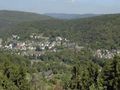
Beautiful double loop around Urftsee and Rursee (between Düren and Monschau; not far from Aachen and the Belgian border) Starting from Heimbach; over Hasenfeld towards Schmidt and further towards Weidenbroich; descent via Steckenborn to Woffelsbach, and then ascent over Rurberg to Kesternich; from there descent towards Einrur, ascent to the nature reserve (formerly military zone) Vogelsang and again descending over Herhahn to Gemünd. From Gemünd ascent to Wolfgarten, descent to Schwammenaueltalsperre, over Hasenfeld back to Heimbach and from there back up towards Abbey Mariawald. Descend to Gemünd and take the rest of the road in the opposite direction (Herhahn - Vogelsang - Einrur - Kesternich - Rurberg - Woffelsbach - Weidenbroich - Schmidt - Hasenfeld).
8 climbs over approximately 110 km; together more than 2000 meters of elevation gain. Good, wide roads, beautiful nature, nowhere extremely steep (the most difficult part is the ascent from Heimbach to Abbey Mariawald).
Vous avez remarqué quelque chose sur cet itinéraire ?Ajouter rapport
Parcourir l'itinéraire dans...
![]() Application RouteYou Ouvrez
Application RouteYou Ouvrez
Vous ne voulez plus voir cette publicité ?
→ Actualiser maintenant
![]()
Veuillez patienter, la navigation est en cours de préparation.
Vous pouvez maintenant naviguer. Bonne route !
Le traitement de la demande a échoué. Veuillez réessayer.
Vous ne voulez plus voir cette publicité ?
→ Actualiser maintenant
![]()
Veuillez patienter, votre téléchargement est en cours de préparation.
Votre téléchargement est prêt. Bonne route !
Le traitement de la demande a échoué. Veuillez réessayer.
Vous ne voulez plus voir cette publicité ?
→ Actualiser maintenant
![]()
Veuillez patienter, votre impression est en cours de préparation.
Votre impression est prête à être téléchargée. Bonne route !
Le traitement de la demande a échoué. Veuillez réessayer.
<iframe src="https://plugin.routeyou.com/routeviewer/free/?language=fr&params.route.id=5204&params.language=en" width="100%" height="600" frameborder="0" allowfullscreen></iframe>
<p><a class="routeYou_embed" href="https://app.routeyou.com/en-de/route/view/5204?utm_source=embed&utm_medium=article&utm_campaign=routeshare&navigation=external" title="Schwammenauel Dam (Eifel, Germany) - RouteYou" target="_blank"><img src="https://image.routeyou.com/embed/route/960x670/5204-en@2x.png" style="width: 100%; height: auto;" alt="Schwammenauel Dam (Eifel, Germany)"></a></p>
Commentaires supplémentaires :
Cette fonctionnalité est exclusivement disponible pour les abonnés RouteYou PREMIUM.
Essayez 1 mois gratuit maintenant et découvrez la différence ! Nous n'exigeons aucune donnée de paiement et le service s'arrête automatiquement après votre période d'essai d'un mois.
© 2006-2025 RouteYou - www.routeyou.com