4159 vues | Public | allemand • français • néerlandais
 Azure
AzureUpdate 20.09.2022: We did this walk again. All paths are accessible.
°°°°°°°°°°°°°°°
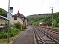
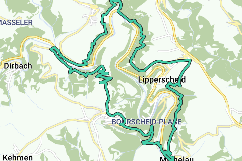
This is definitely a walk for experienced hikers. You can start at the church of Bourscheid and walk down the "Sauer-Moyenne cycle path" to the "Goebelsmühle" where the "Sauer" is crossed. The hike continues in front of the "Goebelsmühle" station, where public transport enthusiasts can start the tour. You climb along narrow paths towards the Sauer side, then descend a few kilometres further down to the hamlet of Unterschlinder.
Along the Sauer we follow the N27 for about 300 meters, then we go up the flank to the village of Lipperscheid. From 'Lipperscheid' we continue to 'Michelau'. On the way you can fully enjoy the beautiful view of the Sûre valley, Bourscheid Castle, the Bourscheid itself and, of course, the beautiful nature that is abundant there. At Michelau, the Sauer is crossed again by a footbridge, which is located next to a railway bridge. From here it is quite a climb to Bourscheid.
On this last part, the walk leads past Bourscheid Castle, which is really worth a detour. If you still feel like it, of course. Don't feel like it? Not bad, it has been there since the 11th century and will stay there for a few days.
Vous avez remarqué quelque chose sur cet itinéraire ?Ajouter rapport
Parcourir l'itinéraire dans...
![]() Application RouteYou Ouvrez
Application RouteYou Ouvrez
Vous ne voulez plus voir cette publicité ?
→ Actualiser maintenant
![]()
Veuillez patienter, la navigation est en cours de préparation.
Vous pouvez maintenant naviguer. Bonne route !
Le traitement de la demande a échoué. Veuillez réessayer.
Vous ne voulez plus voir cette publicité ?
→ Actualiser maintenant
![]()
Veuillez patienter, votre téléchargement est en cours de préparation.
Votre téléchargement est prêt. Bonne route !
Le traitement de la demande a échoué. Veuillez réessayer.
Vous ne voulez plus voir cette publicité ?
→ Actualiser maintenant
![]()
Veuillez patienter, votre impression est en cours de préparation.
Votre impression est prête à être téléchargée. Bonne route !
Le traitement de la demande a échoué. Veuillez réessayer.
<iframe src="https://plugin.routeyou.com/routeviewer/free/?language=fr&params.route.id=1883318&params.language=en" width="100%" height="600" frameborder="0" allowfullscreen></iframe>
<p><a class="routeYou_embed" href="https://app.routeyou.com/en-lu/route/view/1883318?utm_source=embed&utm_medium=article&utm_campaign=routeshare&navigation=external" title="Bourscheid 18.8 km - RouteYou" target="_blank"><img src="https://image.routeyou.com/embed/route/960x670/1883318-en@2x.png" style="width: 100%; height: auto;" alt="Bourscheid 18.8 km"></a></p>
Commentaires supplémentaires :
Cette fonctionnalité est exclusivement disponible pour les abonnés RouteYou PREMIUM.
Essayez 1 mois gratuit maintenant et découvrez la différence ! Nous n'exigeons aucune donnée de paiement et le service s'arrête automatiquement après votre période d'essai d'un mois.
© 2006-2026 RouteYou - www.routeyou.com