10905 vues | Public | allemand • français • néerlandais
 Azure
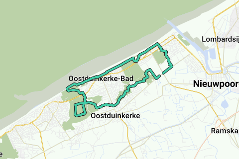
AzureLoop of 16.1km (10Miles) along the dunes and coastline of Nieuwpoort, Oostduinkerke and Koksijde. 50% paved, 50% sandy soil. Ideal for hikers, runners and mountain bikers who want to trek in the dunes. This loop is unsuitable for cyclists (take the polder loop instead). Some dune paths are paved (asphalted), but take into account a number of dune paths through the dune sand. Good for sailing during your run, and keep in mind that the 10Miles takes a bit longer than a 10Miles on fully paved surfaces.
So enjoy yourself!
Quick summary:
Outside a part of the beach zone, the following 7 dune areas and 1 forest are cut in this loop (in order of the loop, counter-clockwise): The Nieuwpoortse Duinen or Kartuizerduinen (hidden left behind the houses, but clearly felt in the sailing game); (after Nieuwpoort-Bad) the Zeebermduinen; (after Oostduinkerke-Bad) the Schipgatduinen and the Doornpanne (Koksijde); the White Burg; (after Oostduinkerke-Dorp) the Plaatsduinen; (and after Mariapark) the Hannecart-Bos and the Ter IJde Duin (along the coast, and alongside on the left, Oostduinkerke).
On top of these dune areas, various interesting buildings (polder farms, dune houses, churches, bunkers) are cut, as well as various beautiful works of art. All this topped with beautiful views from the beach, dike or dune.
Further route description (best is to download the GPX for a correct trace of the dune roads that are not always paved):
The starting point of the loop is at the traffic lights of Kinderlaan with the Polderstraat-Victorlaan to Nieuwpoort (You can of course start the loop at any other place).
Take the Victorlaan towards Nieuwpoort and take the first street on the left (Verliefdenstraat), where you come via a bridge over a stream at the rear of the rest home 'Ter Duinen'. Take there to the right and immediately left before the passage along the Carthusian dunes. Then watch out for the crossing over the busy Elisabethlaan (tram bed: follow the footpath) and the Albert-I-laan at the church. At the dike we take a left towards Oostduinkerke-Koksijde.
At the Kitesurfschool we go on the beach and quickly follow the dune path to and in the dunes, where we encounter various bunkers and bunker tunnels from WWI (asphalted dune path). At a junction we follow the dune path straight ahead (unpaved in part) to the buildings of Oostduinkerke. Turn left there and follow the dike. Several works of art (horse fishermen, cyclist with crab basket) and a public swimming pool are on the route.
At the end of the seawall of Oostduinkerke we take a little right, then left, further parallel to the coastline in the dunes. A little further on we see in the depths a building on the right at the end of a cul-de-sac to the beach. Do not take the beach for a while but take the next dune path upwards, and a little further you will come across another work of art on the dune side. At that artwork we descend to the beach and continue to follow this. Before we arrive in Koksijde we take left back into the dunes. At that place the high dunes stop and show a wide and very low ungrown dune belt along the coast. There we cross back into the dunes and enter the Schipgatduinen, where ships were moored centuries ago. These Schipgat dunes are currently heavily overgrown with thorn plants: Do not take the narrow paths between the dune vegetation (indicated by the red and white ribbons and markings), but first follow the large open dune field parallel to the coastline. Then continue northeast wards in the direction of the southernmost buildings of Oostduinkerke-Bad. You will then cross a large open dune field again. Between this and the last large dune field you have to take there is a small winding dune path. Through this last open dune you come to a house in a dead end street, take it to the end, then turn right to the Albert-I-laaan, cross along the footpath and then continue to the Doornpanne visitor center.
At the Doornpanne we take a right and also go through the domain in a counter-hour clockwise direction. In the Doornpanne everything is quite well paved. There are hatches on the way back that keep the free-running Shetland ponies on their grazing dunes. This way back has a narrower path, but the view is again excellent. Back at the exit of the visitor center we cross the street straight into the Doornpanne forest towards Oostduinkerke-Dorp.
We first go through a grove, and then through the Witte Burg dunes (unpaved dune road) to the massive church in Oostduinkerke-Dorp.
Behind the church we cross the Leopold-II-laan and after a good 200m we take the first dune road on the left through the Plaatsduinen.
At the Nieuwe Ydelaan we take the right and walk through the quiet buildings Mariapark. At the end of this we take a path to the right of a private entrance that takes us through the Hannecart Forest, and at the end along the Yde dunes. We are not going to climb this anymore to cover no more than our 16km.
At the T we take right (Noordzeedreef), and at the next T turn left towards the starting point (Polderstraat).
The full 10Mi (16.1km) was completed at the main entrance of the Sunparks domain. If you walk further to your starting point, you have covered 16.35km.
Vous avez remarqué quelque chose sur cet itinéraire ?Ajouter rapport
Parcourir l'itinéraire dans...
![]() Application RouteYou Ouvrez
Application RouteYou Ouvrez
Vous ne voulez plus voir cette publicité ?
→ Actualiser maintenant
![]()
Veuillez patienter, la navigation est en cours de préparation.
Vous pouvez maintenant naviguer. Bonne route !
Le traitement de la demande a échoué. Veuillez réessayer.
Vous ne voulez plus voir cette publicité ?
→ Actualiser maintenant
![]()
Veuillez patienter, votre téléchargement est en cours de préparation.
Votre téléchargement est prêt. Bonne route !
Le traitement de la demande a échoué. Veuillez réessayer.
Vous ne voulez plus voir cette publicité ?
→ Actualiser maintenant
![]()
Veuillez patienter, votre impression est en cours de préparation.
Votre impression est prête à être téléchargée. Bonne route !
Le traitement de la demande a échoué. Veuillez réessayer.
<iframe src="https://plugin.routeyou.com/routeviewer/free/?language=fr&params.route.id=609270&params.language=en" width="100%" height="600" frameborder="0" allowfullscreen></iframe>
<p><a class="routeYou_embed" href="https://app.routeyou.com/en-be/route/view/609270?utm_source=embed&utm_medium=article&utm_campaign=routeshare&navigation=external" title="Oostduinkerke-Nieuwpoort-Koksijde dunes-loop (16,1km; 10Mi) - RouteYou" target="_blank"><img src="https://image.routeyou.com/embed/route/960x670/609270-en@2x.png" style="width: 100%; height: auto;" alt="Oostduinkerke-Nieuwpoort-Koksijde dunes-loop (16,1km; 10Mi)"></a></p>
Commentaires supplémentaires :
Cette fonctionnalité est exclusivement disponible pour les abonnés RouteYou PREMIUM.
Essayez 1 mois gratuit maintenant et découvrez la différence ! Nous n'exigeons aucune donnée de paiement et le service s'arrête automatiquement après votre période d'essai d'un mois.
© 2006-2026 RouteYou - www.routeyou.com