587 vues | Public | Italien • allemand • français • néerlandais
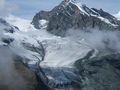
At the Mattmark Stausee there is a very nice little peak nearby where you'll get a tremendous view over the Allalin glacier. From the lake itself you'll only see a very small glimpse of the glacier so it's sure worth a visit!
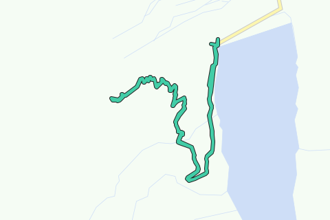
Hike starts at the lake where you follow the right side of the lake and take the first path to the right where you follow a small road up to a small cabine. From there it's a small and sometimes steep path to the summit of the Schwarsbergchopf. Alpinists can go along this route to the Brittanniahütte, the path is well indicated too but requires more equipment.
The return is along the same path.
Vous avez remarqué quelque chose sur cet itinéraire ?Ajouter rapport
Parcourir l'itinéraire dans...
![]() Application RouteYou Ouvrez
Application RouteYou Ouvrez
Vous ne voulez plus voir cette publicité ?
→ Actualiser maintenant
![]()
Veuillez patienter, la navigation est en cours de préparation.
Vous pouvez maintenant naviguer. Bonne route !
Le traitement de la demande a échoué. Veuillez réessayer.
Vous ne voulez plus voir cette publicité ?
→ Actualiser maintenant
![]()
Veuillez patienter, votre téléchargement est en cours de préparation.
Votre téléchargement est prêt. Bonne route !
Le traitement de la demande a échoué. Veuillez réessayer.
Vous ne voulez plus voir cette publicité ?
→ Actualiser maintenant
![]()
Veuillez patienter, votre impression est en cours de préparation.
Votre impression est prête à être téléchargée. Bonne route !
Le traitement de la demande a échoué. Veuillez réessayer.
<iframe src="https://plugin.routeyou.com/routeviewer/free/?language=fr&params.route.id=2259721&params.language=en" width="100%" height="600" frameborder="0" allowfullscreen></iframe>
<p><a class="routeYou_embed" href="https://app.routeyou.com/en-ch/route/view/2259721?utm_source=embed&utm_medium=article&utm_campaign=routeshare&navigation=external" title="To the Schwarzbergchopf (2871m) - RouteYou" target="_blank"><img src="https://image.routeyou.com/embed/route/960x670/2259721-en@2x.png" style="width: 100%; height: auto;" alt="To the Schwarzbergchopf (2871m)"></a></p>
Commentaires supplémentaires :
Cette fonctionnalité est exclusivement disponible pour les abonnés RouteYou PREMIUM.
Essayez 1 mois gratuit maintenant et découvrez la différence ! Nous n'exigeons aucune donnée de paiement et le service s'arrête automatiquement après votre période d'essai d'un mois.
© 2006-2025 RouteYou - www.routeyou.com