6758 vues | Public | allemand • français • néerlandais
 Azure
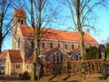
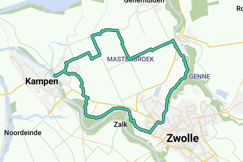
AzureThe Mastenbroek polder consists largely of grassland (Mastenbroek means low and soggy land). This polder Mastenbroek east of Kampen is one of the oldest polders in the Netherlands. In 1364 the area was one of the first polders to be drained. At the end of the Middle Ages, these extractions started by reclamating the peatlands. After the reclamation, waterings were dug. The original linear mining structure of the polder is still clearly visible in the tight pattern of rectilinear ditches, roads and weterings. The large open spaces and the agricultural buildings in between are also characteristic of this polder. The inhabitants settled on the long, narrow roads along the wetering. Because of the risk of flooding that lurked behind the Kamperzeedijk, many farms were built on house mounds. The Mastenbroek polder is enclosed between the IJssel, Zwolle, Kampen, Hasselt and Genemuiden. The adjacent met Kampen, Zwartewaterland and Zwolle want to expand in the direction of the polder, increasing the pressure on the area. In order to preserve the identity and quality of the area, the Mastenbroek polder is included in the Belvédère Memorandum, published by the Ministry of Education, Culture and Science in 1999. The central government wants to preserve the characteristic, valuable landscape of the medieval polder Mastenbroek, but is open to development.
Vous avez remarqué quelque chose sur cet itinéraire ?Ajouter rapport
Parcourir l'itinéraire dans...
![]() Application RouteYou Ouvrez
Application RouteYou Ouvrez
Vous ne voulez plus voir cette publicité ?
→ Actualiser maintenant
![]()
Veuillez patienter, la navigation est en cours de préparation.
Vous pouvez maintenant naviguer. Bonne route !
Le traitement de la demande a échoué. Veuillez réessayer.
Vous ne voulez plus voir cette publicité ?
→ Actualiser maintenant
![]()
Veuillez patienter, votre téléchargement est en cours de préparation.
Votre téléchargement est prêt. Bonne route !
Le traitement de la demande a échoué. Veuillez réessayer.
Vous ne voulez plus voir cette publicité ?
→ Actualiser maintenant
![]()
Veuillez patienter, votre impression est en cours de préparation.
Votre impression est prête à être téléchargée. Bonne route !
Le traitement de la demande a échoué. Veuillez réessayer.
<iframe src="https://plugin.routeyou.com/routeviewer/free/?language=fr&params.route.id=40325&params.language=en" width="100%" height="600" frameborder="0" allowfullscreen></iframe>
<p><a class="routeYou_embed" href="https://app.routeyou.com/en-nl/route/view/40325?utm_source=embed&utm_medium=article&utm_campaign=routeshare&navigation=external" title="Mastenbroek route - RouteYou" target="_blank"><img src="https://image.routeyou.com/embed/route/960x670/40325-en@2x.png" style="width: 100%; height: auto;" alt="Mastenbroek route"></a></p>
Commentaires supplémentaires :
Cette fonctionnalité est exclusivement disponible pour les abonnés RouteYou PREMIUM.
Essayez 1 mois gratuit maintenant et découvrez la différence ! Nous n'exigeons aucune donnée de paiement et le service s'arrête automatiquement après votre période d'essai d'un mois.
© 2006-2026 RouteYou - www.routeyou.com