246 vues | Public | allemand • français • néerlandais
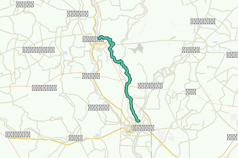
This 36.5 Km long kayak tour brings you from Bang Kaeo in Ang Thong to the mouth of the Lopburi River in Ayutthaya over the Bang Kaeo Canal. The Bang Kaeo Canal is a part of the former Bang Kaeo River, a defunct river which river bed at present still can be traced back along different irrigation canals. In the Ayutthayan era, the river had its source at the split of the Chao Phraya River in Bang Kaeo in the same way the Lopburi River had its origin at Bang Phutsa.
The river ran in the present Bang Kaeo Canal for 13.5 kilometers and turned southwest at Wat Han Sang. In 1813 there was an attempt to make use of the Bang Kaeo river to deviate the Chao Phraya to Ayutthaya. The Chao Phraya was blocked off near Ang Thong and pushed into the Bang Kaeo Canal. Near Ban Mai (Maha Rat) the waterway was deviated into the Lopburi River via a 1.5 Km long channel. It resurfaced in the Bang Kaeo River bed near Ban Mai (Ayutthaya), 5 Km south of Wat Chula Mani, but the attempt to give the Chao Phraya a new river bed failed and the project was abandoned.
The Bang Kaeo canal at present runs from its split off from the Chao Phraya at Bang Kaeo until Hua Phai in Maha Rat district. At Hua Phai it flows into the Lopburi River near Wat Pak Khlong. On the Bang Kaeo Canal are two water regulators, one at the source of the canal in Bang Kaeo and the second at Hua Phai near its mouth and confluence with the Lopburi River.
The tour will take 7-8 hours according to your level of physical fitness, the conditions of the water current, and your personal kayaking experience. Travel time will expand if you stop to visit every highlight listed on this tour itinerary. Nevertheless, we have listed a few extra sites for the sake of smoother navigation and to alert kayakers to possible locations for obtaining water and other supplies. Individual kayakers can choose where to stop according to their own tastes and time constraints.
Tips and Warnings
General - Stock up supplies of water (500 ml/hr), electrolyte beverages (3-4 bottles) and dry food (take a snack every 2 hours) as there is hardly opportunity to find a meal on this itinerary. Keep up mobile communications with somebody for emergency cases and do know where you are exactly at all times. Protect your equipment with waterproof bags and tie everything to the boat.
Water currents - The most important variable for making kayaking plans is water current. Rainy season will result in flooding and/or rapidly moving water. In this case not every kayak is suitable. Use caution when the current is fast and wear a life jacket.
Clothing - Wear a good hat and loose-fitting clothing that dries quickly. Long pants and shirts with long sleeves may be useful and appropriate to protect you from the sun. The refracted sunlight from the water makes sunburn commonplace, so put on plenty of sun block on not covered parts of your body and wear sunglasses.
Who are we?
Ayutthaya Kayaking Experience [AKE] is a sportive subsidiary from Ayutthaya Historical Research [AHR]. AKE’s objective is to promote kayaking tourism in Ayutthaya, by basically showing kayak presence on canals and rivers. Kayaking is the perfect outdoor recreation to explore the city island contours and its surroundings. We are local expatriates who have been living in Ayutthaya for many years and would like to share our kayak knowledge with other sportsmen. More information on AKE can be found at: http://www.aykaex.yolasite.com/
Disclaimer
AHR will not be held liable for any loss or damage whatsoever for any suggestions made in relation to the site’s promotion of ecotourism. It is the responsibility of the user of the site to take the necessary precautions to avoid any physical injury, traffic incident, animal attack, theft, and damage to equipment. Any reliance on the site’s information is therefore strictly at your own risk. Read our full disclaimer at website www.ayutthaya-history.com
©2010-2014 Ayutthaya Kayaking Experience
All rights reserved.
Vous avez remarqué quelque chose sur cet itinéraire ?Ajouter rapport
Parcourir l'itinéraire dans...
![]() Application RouteYou Ouvrez
Application RouteYou Ouvrez
Vous ne voulez plus voir cette publicité ?
→ Actualiser maintenant
![]()
Veuillez patienter, la navigation est en cours de préparation.
Vous pouvez maintenant naviguer. Bonne route !
Le traitement de la demande a échoué. Veuillez réessayer.
Vous ne voulez plus voir cette publicité ?
→ Actualiser maintenant
![]()
Veuillez patienter, votre téléchargement est en cours de préparation.
Votre téléchargement est prêt. Bonne route !
Le traitement de la demande a échoué. Veuillez réessayer.
Vous ne voulez plus voir cette publicité ?
→ Actualiser maintenant
![]()
Veuillez patienter, votre impression est en cours de préparation.
Votre impression est prête à être téléchargée. Bonne route !
Le traitement de la demande a échoué. Veuillez réessayer.
<iframe src="https://plugin.routeyou.com/routeviewer/free/?language=fr&params.route.id=292915&params.language=en" width="100%" height="600" frameborder="0" allowfullscreen></iframe>
<p><a class="routeYou_embed" href="https://app.routeyou.com/en-th/route/view/292915?utm_source=embed&utm_medium=article&utm_campaign=routeshare&navigation=external" title="Ang Thong - Ayutthaya Kayak Track - RouteYou" target="_blank"><img src="https://image.routeyou.com/embed/route/960x670/292915-en@2x.png" style="width: 100%; height: auto;" alt="Ang Thong - Ayutthaya Kayak Track"></a></p>
Commentaires supplémentaires :
Cette fonctionnalité est exclusivement disponible pour les abonnés RouteYou PREMIUM.
Essayez 1 mois gratuit maintenant et découvrez la différence ! Nous n'exigeons aucune donnée de paiement et le service s'arrête automatiquement après votre période d'essai d'un mois.
© 2006-2026 RouteYou - www.routeyou.com