195 vues | Public | allemand • français • néerlandais
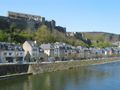
The river meander known as 'Le Tombeau du Géant' has inspired many landscape painters and photographers. It provides the backdrop for this beautiful walk along the banks of the Semois. At the viewpoint of Botassart, the clear blue sky allows for the observation of the stunning meander of the Semois, along with the band of green that surrounds it. From here, the path winds along withered shrubs down to the banks of the Semois. Here, just like elsewhere in the region, you will discover an authentic river. The path along the Semois is magnificent. The clear water clearly shows the strands of green algae. In the sunlight, the shades of the river range from blue to phosphorescent green. It’s like an impressionist painting. At the Moulin de l’Epine, the path spirals up to the hilltops above Bouillon. Upon leaving the forest, the panoramic tower appears, offering a beautiful perspective of the ancient city. The descent takes place along a protruding path that can compete with the most beautiful mountain routes. On the return, you follow the Grand Ruisseau, a tributary of the Semois, concluding this lovely walk. Walks from the brochure "20 unforgettable hikes" can be consulted and downloaded here: walloniebelgietoerisme.be/nl/3/doen/sportactiviteiten/wandelen/wandelbrochures
Vous avez remarqué quelque chose sur cet itinéraire ?Ajouter rapport
Parcourir l'itinéraire dans...
![]() Application RouteYou Ouvrez
Application RouteYou Ouvrez
Vous ne voulez plus voir cette publicité ?
→ Actualiser maintenant
![]()
Veuillez patienter, la navigation est en cours de préparation.
Vous pouvez maintenant naviguer. Bonne route !
Le traitement de la demande a échoué. Veuillez réessayer.
Vous ne voulez plus voir cette publicité ?
→ Actualiser maintenant
![]()
Veuillez patienter, votre téléchargement est en cours de préparation.
Votre téléchargement est prêt. Bonne route !
Le traitement de la demande a échoué. Veuillez réessayer.
Vous ne voulez plus voir cette publicité ?
→ Actualiser maintenant
![]()
Veuillez patienter, votre impression est en cours de préparation.
Votre impression est prête à être téléchargée. Bonne route !
Le traitement de la demande a échoué. Veuillez réessayer.
<iframe src="https://plugin.routeyou.com/routeviewer/free/?language=fr&params.route.id=12011531&params.language=en" width="100%" height="600" frameborder="0" allowfullscreen></iframe>
<p><a class="routeYou_embed" href="https://app.routeyou.com/en-be/route/view/12011531?utm_source=embed&utm_medium=article&utm_campaign=routeshare&navigation=external" title="Botassart: Where a river flows… - RouteYou" target="_blank"><img src="https://image.routeyou.com/embed/route/960x670/12011531-en@2x.png" style="width: 100%; height: auto;" alt="Botassart: Where a river flows…"></a></p>
Commentaires supplémentaires :
Cette fonctionnalité est exclusivement disponible pour les abonnés RouteYou PREMIUM.
Essayez 1 mois gratuit maintenant et découvrez la différence ! Nous n'exigeons aucune donnée de paiement et le service s'arrête automatiquement après votre période d'essai d'un mois.
© 2006-2026 RouteYou - www.routeyou.com