Grâce à notre partenaire haroldslegers, vous pouvez accéder gratuitement à cet itinéraire - et découvrir RouteYou PLUS.
Découvrez tous les avantages2281 vues | Public | allemand • français • néerlandais
 Azure
AzureLast updated on June 21, 2019: the built-up area of Neupré is avoided as much as possible.
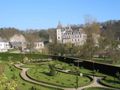
Condroz is a region west of the Ardennes, where agriculture is mainly practiced. The ridges of this region have a southwest-northeast orientation. In the valleys are small forests, estates and castles. The roads in this area are generally of reasonable to good quality, with a few exceptions (especially the road between Saint-Séverin and Yernée is bad). In August 2017, roads were mainly built around Neupré and between Poulseur and Anthisnes. Although routeyou states that about 1250 altimeters need to be overcome, with a Garmin Edge 800, I recorded about 1600 altimeters.
Beautiful starting point is Place Esneux, where there is a large car park along the Ourthe. You follow the track counterclockwise.
The main road out of Esneux was soon abandoned to climb the steep coast of Strivay. Then you climb the Col de Bonsgnée. Then it goes up and down to the Meuse valley.
The main road from Yernée to the foot of the Côte de la France is very busy, but once you turn around to start the ascent of the Côte de la France, you are back in peace and nature. Then, it crosses small villages typical of Condruzian (and climbs, like the Thier de Scry), towards Modave.
From Modave to Clavier, follow the paved cycle path on the old Ciney - Marchin line, see http://www.bahntrassenradeln.de/bahneur_bel.htm#be126 for more information (in German). The railway tunnel under Modave has been preserved and the cycle path now runs through it, but this track ends up on the cycle path just after the railway tunnel. At Clavier, you leave the cycle path and head to the beautiful hamlet of Vervoz, where there is a farm, chapel and lakeside castle.
Then you will go to Borlon, where you will climb to the highest point of the track. Just after the top of the Côte de Borlon, you have a magnificent view of the Ardennes. If you come from the other side, the climb is called Côte de Petite-Somme. Via the Petite Somme, where there is a beautiful castle, you descend steeply towards Petit Han. The last part concerns the busy main road. However, you quickly leave this main road to climb the Beech Field: a beautiful road, quiet, through a very beautiful nature and an excellent road surface.
Then you descend to the smallest (and very touristy) town in Belgium: Durbuy, in the Ourthe Valley. Via the Côte de Warre you quickly leave the Ourthe valley. Via Tohogne and Hermanne, you enter the Neblon Valley, which you follow upstream for a longer period. Then leave the Neblon Valley and climb to Ouffet.
By a steeply hilly road to Ellemelle, and a descent via the Mont, you arrive near Poulseur. You climb through the village of Le Sart and get a wonderful view of the Ourthe valley and the rocks around Poulseur. A steep descent takes you to Poulseur, then you follow the concrete cycle path along the Ourthe to finally find yourself in Esneux.
More photos of this route can be found at: https://goo.gl/photos/FD8HBz2eAi7uCRpu6
Vous avez remarqué quelque chose sur cet itinéraire ?Ajouter rapport
Parcourir l'itinéraire dans...
![]() Application RouteYou Ouvrez
Application RouteYou Ouvrez
![]()
Veuillez patienter, votre impression est en cours de préparation.
Votre impression est prête à être téléchargée. Bonne route !
Le traitement de la demande a échoué. Veuillez réessayer.
<iframe src="https://plugin.routeyou.com/routeviewer/free/?language=fr&params.route.id=4749769&params.language=en" width="100%" height="600" frameborder="0" allowfullscreen></iframe>
<p><a class="routeYou_embed" href="https://app.routeyou.com/en-be/route/view/4749769?utm_source=embed&utm_medium=article&utm_campaign=routeshare&navigation=external" title="Ronde du Condroz - RouteYou" target="_blank"><img src="https://image.routeyou.com/embed/route/960x670/4749769-en@2x.png" style="width: 100%; height: auto;" alt="Ronde du Condroz"></a></p>
Commentaires supplémentaires :
Cette fonctionnalité est exclusivement disponible pour les abonnés RouteYou PREMIUM.
Essayez 1 mois gratuit maintenant et découvrez la différence ! Nous n'exigeons aucune donnée de paiement et le service s'arrête automatiquement après votre période d'essai d'un mois.
© 2006-2026 RouteYou - www.routeyou.com