Grâce à notre partenaire Pasar vzw, vous pouvez accéder gratuitement à cet itinéraire - et découvrir RouteYou PLUS.
Découvrez tous les avantages2280 vues | Public | allemand • français • néerlandais
 Azure
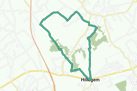
AzureAppointment at the Sint Bartolomeuskerk (V), the village church of Hillegem, borough of Herzele. The Hillegemplein is located near the N46, the provincial road between Aalst and Oudenaarde, and there is ample parking space. You can also get there with the Lijnbus no. 91 Aalst – Zottegem. Walk to the right into Ledebergstraat and immediately before and next to the school entrance to the left on a narrow tiled path. After 100 m, cross the asphalt road and go straight ahead, next to house number 14, still on a narrow tiled road. After 250 m, at a crossroads of field roads, walk straight on the gravel road next to house number 36A and then on the slightly raised grass verge in the extension of the gravel road. A narrow path takes you straight across the fields to a crossroads of wider field roads at the opposite corner of the field. This path is regularly plowed and strewn, but it is a church road (sometimes completely invisible!). So even if you get there just after plough or egge: walk straight north and after 250 m you are on a wider field road at a small information board. The view is miles wide.
.
Walk straight down on a wide earth road in the extension of the church road and still directly north. The earth road becomes asphalt. You come here to the hamlet of Cotthem, a beautiful rural corner of Sint-Lievens-Esse. On the right is soon De Boomgaard¹, a tavern-restaurant, annex Bed & Breakfast. 50 m further, at a large Lourdes cave between the ivy, turn right (sign Cotthem hiking trail). On the left you can taste regional dishes and dozens of regional beers in Kaffee De Pikardijn². The road curves to the left and descends further. After 400 m, just past the Kottembeek, turn right into a narrow road (sign Cotthemwandelroute). Walk along the edge of the forest until the T-junction and turn left on the concrete road. Always straight ahead. Cross the main road (N462) and turn right. Walk past and right next to the building of Garage Cammaert to the left on the asphalt and after 50 m straight on a tiled path. Follow right, cross the cobblestone crossroads and walk straight ahead into Hoeksken. After 75 m, next to house number 60, turn right into the asphalt road. Turn left and walk straight on the tiled path after 100 m. Turn left on the wide concrete road and continue straight on the asphalt road after 50 m. Walk 500 m further right into Blareveld. At the T-junction turn left (sign Rodelandroute 2) and then straight ahead at the intersection.
The landscape is still wide and the peace is only sporadically disturbed by a passing agricultural tractor. At the end of the concrete road, walk to the right on the gravel road and after 20 m to the left on a narrow road between meadow and field. After 250 m you will be back on the concrete road. Turn left and continue for 600 m at the T-junction (sign Leegbracht) to the right and after 20 m to the left on a wide field road. The field road descends a bit further and becomes a deep, muddy hollow road. Boots are not a luxury here in winter.
Ignore a field road on the left and turn slightly to the right and immediately, after a small O.-L.-V. chapel³ on the right, turn left again. Once out of the forest, the field road becomes an asphalt road, which takes you into the housing and into a concrete road. Turn left and after 50 m to the right and immediately to the right again along the busy N462. Cross after 20 m and walk into the Cotthemstraat. Ignore left and right exits and walk straight ahead and up on a narrow path, first along the edge of the forest and then between fence and field until you reach a wide field road.
The village is Oombergen and in front of you is the stone hull of a former windmill4now converted into a house. Walk to the left and after 250 m at two rest benches with a devotional chapel5 to the right in a hollow road. From here straight ahead and after 600 m you are again at the village church of Hillegem.
Vous avez remarqué quelque chose sur cet itinéraire ?Ajouter rapport
Parcourir l'itinéraire dans...
![]() Application RouteYou Ouvrez
Application RouteYou Ouvrez
![]()
Veuillez patienter, votre impression est en cours de préparation.
Votre impression est prête à être téléchargée. Bonne route !
Le traitement de la demande a échoué. Veuillez réessayer.
<iframe src="https://plugin.routeyou.com/routeviewer/free/?language=fr&params.route.id=5295222&params.language=en" width="100%" height="600" frameborder="0" allowfullscreen></iframe>
<p><a class="routeYou_embed" href="https://app.routeyou.com/en-be/route/view/5295222?utm_source=embed&utm_medium=article&utm_campaign=routeshare&navigation=external" title="Kouter walk in Hillegem - RouteYou" target="_blank"><img src="https://image.routeyou.com/embed/route/960x670/5295222-en@2x.png" style="width: 100%; height: auto;" alt="Kouter walk in Hillegem"></a></p>
Commentaires supplémentaires :
Cette fonctionnalité est exclusivement disponible pour les abonnés RouteYou PREMIUM.
Essayez 1 mois gratuit maintenant et découvrez la différence ! Nous n'exigeons aucune donnée de paiement et le service s'arrête automatiquement après votre période d'essai d'un mois.
© 2006-2026 RouteYou - www.routeyou.com