

Grâce à notre partenaire Pasar vzw, vous pouvez accéder gratuitement à cet itinéraire - et découvrir RouteYou PLUS.
Découvrez tous les avantages
 Azure
AzureGo to the church square of Melkwezer (V), district of Linter in the south of Hageland. Turning your back to the Sint-Pancratiuskerk, you enter the Dorpstraat on the left and exit the village basin, direction Wommersom. At the last houses, cross the intersection with the Lindestraat and diagonally to the left into the Negenbunderweg. Immediately, the fertile Hageland unfolds. Ignore the secondary roads, also the Bosweg on the left. But 60 m after this road, at the T-intersection with bank, turn right into the country road, towards the antenna mast. This road crosses the nature reserve of Walsbergen, voted most beautiful place in Linter by Pasar in 2009. In the 90s, this precious piece of nature, on the ridge between the Kleine and Grote Gete valleys, was saved from the planned clearing. It consists of ancient groves of oak and beech and wet meadows, including species of orchids, rattlesnakes, blue knots, etc. All kinds of amphibians also survive here, such as the alpine water salamander and the endangered crested salamander, which is on the "red list". Through wooden doors and an information panel 1, you always walk straight, until you reach the traffic road. Here is a second information panel with the Pasar label of the "most beautiful place" next door. On the other side is the ancient Walsbergerhoeve, where in the 13th century there was a monastery that was later taken over by the Order of Malta's Templars. Follow the Dorpstraat on the right for 320 m. At the bus stop, turn left into the concrete road, soon with a vast view of the Grote Gete valley and in the foreground Wommersom Castle (1880). At the castle you have to turn left. This spacious building, flanked by the castle farm, is beautifully framed by a circular canal. Follow the equally beautiful entrance of the young lime trees, the Melkwezerstraat, which slowly turns to the right. You will arrive at the 't Serclaeskapel (1835), dedicated to Our Lady. Immaculate Conception, and a picturesque and shady picnic area 2 on the banks of a stream. On the right, take the path next to the creek, as well as the Great Gete hiking trail. A little further on, you turn left and then collide with the Hertogengracht, flanked by a row of silver birches; there on the left. This canal was built in the 13th century by the Brabant Duke Henry I to drain the lower fields. After all, the Grote Gete itself was dammed and pushed up at the time to serve a series of mills. Where the Hertogengracht begins, near the Grote Gete, you walk on Getedijk 3 on the right. You now follow the slightly winding river for a long time, which is already quite wide here. Through a beautiful river landscape: canals and ditches, hedges and rows of trees, ducks and sometimes a heron or buzzard. In the old nest of hollow Pollard willows, owls, kestrels, woodpeckers, bats: the "cave brothers". On the northern horizon, the silhouette of Neerlinter appears. Ignore the bridge on the road to Neerlinter. From there, you advance 500 m further on the, until the exit on the right; the Doysbroeckweg. There you leave the path of the bank. To your left and right, between Grote Gete and 's Hertogengracht, is the nature reserve Doysbroek 4 (17 ha), also nominated for the election of the "most beautiful place" in Linter. This paradise for frogs, salamanders and other amphibians is freely accessible on the trails. In the groves of trousers thrive alder, Gelderland rose, elderberry, honeysuckle, etc. Cross the Hertogengracht and follow the Doysbroekweg for 250 m. Then turn left onto the Field Road, just like the Grote Getepad. You can continue to follow this to the terminus. Turn right once more on the concrete, the Hazenbergweg through the fields, and cross the Hazenbergstraat to the first houses. The left-diagonal Begijnhofstraat takes you back to the centre of Melkwezer
Vous avez remarqué quelque chose sur cet itinéraire ?Ajouter rapport
Parcourir l'itinéraire dans...
 Application RouteYou Ouvrez

Veuillez patienter, votre impression est en cours de préparation.
Votre impression est prête à être téléchargée. Bonne route !
Le traitement de la demande a échoué. Veuillez réessayer.
<iframe src="https://plugin.routeyou.com/routeviewer/free/?language=fr&params.route.id=5343477&params.language=en" width="100%" height="600" frameborder="0" allowfullscreen></iframe>
<p><a class="routeYou_embed" href="https://app.routeyou.com/en-be/route/view/5343477?utm_source=embed&utm_medium=article&utm_campaign=routeshare&navigation=external" title="Along the most beautiful natural sites of Linter - RouteYou" target="_blank"><img src="https://image.routeyou.com/embed/route/960x670/5343477-en@2x.png" style="width: 100%; height: auto;" alt="Along the most beautiful natural sites of Linter"></a></p>
Commentaires supplémentaires :
Cette fonctionnalité est exclusivement disponible pour les abonnés RouteYou PREMIUM.
Essayez 1 mois gratuit maintenant et découvrez la différence ! Nous n'exigeons aucune donnée de paiement et le service s'arrête automatiquement après votre période d'essai d'un mois.
© 2006-2026 RouteYou - www.routeyou.com



 Pasar vzw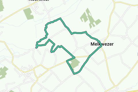






 Télécharger


