11394 vues | Publique | Néerlandais
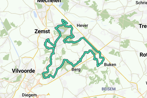
The Witloofroute is a signposted route that is mainly located in the triangle Haachtsesteenweg - Leuvensevaart - E19.
This itinerary takes two issues into account:
1. Due to the recent reconstruction of the Tervuursesteenweg, this black point in the Witloofroute has finally been solved for cyclists. Now this part can be cycled safely in Elewijt. This GPX takes this into account.
2. Once past Kampenhout (the center of this route) the official route runs past the castles Ten opstal and ter Loost, and passes the chicory museum in Kampenhout-Sas. All 3 of these are located under the busy Haachtsesteenweg: The first crossing is done via traffic lights, the second crossing (back way) along the bicycle loop under the Haachtsesteenweg - Leuvensesteenweg junction at Kampenhout-Sas (where the Leuvensevaart takes two sharp turns). This GPX remains on the left side of the Leuvensesteenweg and crosses the Haachtsesteenweg in the opposite direction of cycling. That way you are quickly at the Leuvensevaart for your trip north along the canal towards Boortmeerbeek.
However, you can also stay north of the Haachtsesteenweg and avoid these points of attention. Once past Kampenhout and you drive south to the Haachtsesteenweg, turn left to the Sint-Jozefshoeve (waterhoeve). Keep this farm to your right as well as the Weisetterbos along this farm. You then drive 150m on an unpaved country road further and further from the forest, and arrive at the towpath on the left bank of the Leuvensevaart. This is a shortening of about 7.5 km, making the loop a total of 42 km long.
Official information about this loop can be found on the site of the Province of Flemish Brabant (pdf of the route - without the adjustments below - and a text description on http://www.toerismevlaamsbrabant.be/fietsen/fietsproducten/witloofroute/index.jsp ).
The starting point of this GPX is at the parking of the Bloso swimming pool in Hofstade, opposite the Hofstade train station.
This GPX runs in a counterclockwise direction along the centers of Elewijt, Weerde, Boekt, Melsbroek, Peutie, Kampenhout and Kampenhout-Sas, and via Schiplaken and Hofstade back to the starting point. Plenty of stops for a nap and a drink!
You can of course start this loop anywhere.
This zone explores the northern zone of the chicory region, and it regularly comes close to some castles. The most visible are the Rubens Castle, Huyenhoven Castle and the adjacent Ravaart Castle, Ribeaucourt Castle in the distance, Ten Opstal Castle and adjacent Ter Loonst Castle, and Schiplaken Castle.
There are other old castles and buildings where cycling is close by (see the POIs for a possible detour). You will also notice the Weerdemolen, Laathof farm and Hof Ten As. However, you will not be able to notice several other Farms and Castles from the public road.
You can also cycle through the Floordambos in Melsbroek, on the north side of the Hellebos in Kampenhout and through the Schiplakenbos.
In the center of Kampenhout you can admire the statue of the chicory farmer, and visit the chicory museum at the bicycle loop in Kampenhout-Sas (see http://www.kampenhout.be/toerisme/witloofmuseum/index.php).
Some short sections are not paved but still sufficiently paved.
A varied and above all flat course for everyone, also perfect to do with children, including various locations through village centers for a drink and a drink.
Parcourir l'itinéraire dans...
![]() Application RouteYou Ouvrez
Application RouteYou Ouvrez
Plus voir cette annonce?
→ Améliorez maintenant
![]()
Veuillez patienter, la navigation est en cours de préparation.
Vous pouvez maintenant naviguer. Amusez-vous en route!
Le traitement de votre requête a échoué. S'il vous plaît réessayez.
Plus voir cette annonce?
→ Améliorez maintenant
![]()
Veuillez patienter, votre téléchargement est en cours de préparation.
Votre téléchargement est prêt. Amusez-vous en route!
Le traitement de votre requête a échoué. S'il vous plaît réessayez.
Plus voir cette annonce?
→ Améliorez maintenant
![]()
Veuillez patienter, votre impression est en cours de préparation.
Votre impression est prête à être téléchargée. Amusez-vous en route!
Le traitement de votre requête a échoué. S'il vous plaît réessayez.
Plus voir cette annonce?
→ Améliorez maintenant
![]()
Veuillez patienter, votre téléchargement est en cours de préparation.
Votre téléchargement est prêt. Amusez-vous en route!
Le traitement de votre requête a échoué. S'il vous plaît réessayez.
<iframe src="https://plugin.routeyou.com/routeviewer/free/?language=fr&params.route.id=1053101&params.language=en" width="100%" height="600" frameborder="0" allowfullscreen></iframe>
<a href="https://www.routeyou.com/en-be/route/view/1053101/recreational-cycle-route/chicory-route-49-5km-or-42km?utm_source=embed&utm_medium=article&utm_campaign=routeshare" title="Chicory route (49,5km or 42km) - RouteYou" target="_blank"><img src="https://image.routeyou.com/embed/route/960x670/1053101-en@2x.png" width="960" height="670" alt="Chicory route (49,5km or 42km)"></a>
Commentaires supplémentaires:
Essayez cette fonctionnalité gratuitement avec un abonnement d'essai RouteYou Plus.
Si vous avez déjà un tel compte, connectez-vous maintenant.
Essayez cette fonctionnalité gratuitement avec un abonnement d'essai RouteYou Premium.
© 2006-2024 RouteYou - www.routeyou.com