Grazie al nostro partner Tourist Board South Limburg (Visit Zuid-Limburg), puoi accedere gratuitamente a questo itinerario e conoscere RouteYou PLUS.
Scopri tutti i vantaggi Azure
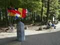
AzureWelcome to the beautiful city of South Limburg and especially to the municipality of Vaals. This route crosses borders and takes you from the Netherlands, to the Drielandenpunt, to Belgium and back.
This area is worth more than a visit. You have a beautiful view of the hills of southern Limburg. The labyrinth or one of the two observation towers are located on the course. In the center of Vaals or on the Drielandenpunt there are many catering establishments for a good cup of coffee.
Note: This route is not marked, but can also be downloaded via a special PDF (see under 'Download' under 'PDF printing'). Here you will find a pdf with a written description of the route.
It is possible to park in one of the many car parks in the centre of Vaals (kerkstraat / tentstraat), Kasteel Vaalsbroek or the Drielandenpunt.
If you have any comments on the route, you can report them via routepunt@visitzuidlimburg.nl.
A complete hiking map with several dozen other hiking trails in this area is easy to order via www.visitzuidlimburg.nl/webshop.
Hai notato qualcosa su questo itinerario?Aggiungere un problema
Naviga nel percorso in...
![]() App RouteYou Aprire
App RouteYou Aprire
![]()
Attendi, la tua stampa è in preparazione.
La tua stampa è pronta per il download. Buon divertimento in viaggio!
Elaborazione della richiesta non è riuscita. Si prega di riprovare.
<iframe src="https://plugin.routeyou.com/routeviewer/free/?language=it&params.route.id=4219993&params.language=en" width="100%" height="600" frameborder="0" allowfullscreen></iframe>
<p><a class="routeYou_embed" href="https://app.routeyou.com/en-be/route/view/4219993?utm_source=embed&utm_medium=article&utm_campaign=routeshare&navigation=external" title="Hiking trail - Vaals - From Vaals to Moresnet - RouteYou" target="_blank"><img src="https://image.routeyou.com/embed/route/960x670/4219993-en@2x.png" style="width: 100%; height: auto;" alt="Hiking trail - Vaals - From Vaals to Moresnet"></a></p>
Altri commenti:
Questa funzionalità è disponibile esclusivamente per gli abbonati a RouteYou PREMIUM.
Prova 1 mese gratis e scopri la differenza! Non prendiamo alcun dettaglio di pagamento e la tua prova termina automaticamente dopo un mese.
© 2006-2026 RouteYou - www.routeyou.com