Grazie al nostro partner Pasar vzw, puoi accedere gratuitamente a questo itinerario e conoscere RouteYou PLUS.
Scopri tutti i vantaggi Azure
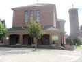
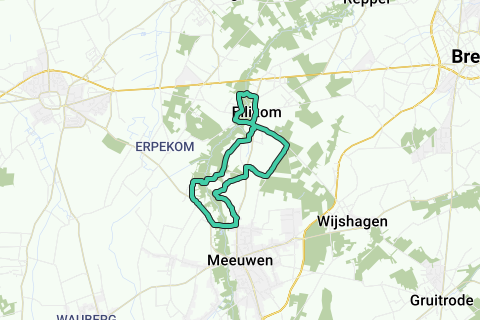
AzureStarting place is the square in front of the village church of Ellikom, part of Meeuwen-Gruitrode. The modern church of the HH. Harlindis and Relindis dates from 1958-1960. Ignore the Brogelerweg on the left side of the church and walk diagonally left into the Betonweg (here street name). Ignore a first street on the left and after 300 m turn left into the Neermolenweg. The asphalt road becomes gravel road and brings you to the Abeek. On the right is the Neermolen, probably the oldest water grain mill (1448) of Ellikom, but now hardly recognizable as a mill without a wheel. Cross the Abeek and after a few meters also a canal and continue walking on a wide forest road. At the T-junction you turn left on a beautiful field road between meadow and forest. On the asphalt road you go straight ahead and 50 m further at the T-junction to the right. After 150 m to the left on Brogelerweg 3 t16 and another 150 m further you walk to the left on a gravel road into the forest. Left and right, the wet undergrowth is overgrown by giant balsam. The forest road brings you back to the Abeek and here the Hoogmolen. The Hoogmolen or Peerdermolen is an underlay mill, dates from before 1500 and was restored in 2007. Right in front of the mill is a beautiful 2 1 V long-gabled farm. Mill and farm are protected as a village view. After the mill you walk on asphalt again and on the main road you turn right. 100 m further and immediately after the bend you turn right into the Hellestraat. Turn right and continue straight at the fork (sign Natuurleerpad). After 100 m you walk to the left (sign Natuurleerpad).
The asphalt road becomes earth road and takes you first along and then into a forest with mainly Scots pine. After more than a kilometer, at a crossroads with rest bench and asphalt road, turn right on a forest road (sign Vallei van de Abeek). 200 m further you walk to the left. The winding dirt road takes you again to the Abeek and now to the old Berenheidermolen. The original mill dated from 1717 and was an oil mill. It was renovated into a home in the 1990s and is somewhat hidden from view by a hedge and lush vegetation.
Leave the beautiful surroundings of the mill behind you and at the T-junction, at the end of the dirt road, walk to the left and then straight on the asphalt until you reach the main road. Here to the left and for 650 m along the busy stone road between Peer and Meeuwen. Straight across house number 35 you walk to the left on an asphalt road and at the T-junction you turn left again. Soon you reach the Dorpermolen and the associated tension. The Dorpermolen dates from before 1470 and used to be a grain and ban mill. It has now been renovated into a tavern and, like the Peerdermolen, was protected as a monument and together with the surroundings as a village view. 300 m past the mill you come to the stone road. Walk to the left and 200 m further left again into Luythegge. The asphalt road bends to the left after 500 m and a little later sharply to the right. In the next bend, ignore the field road straight ahead and stay left on the asphalt. 100 m further you choose the wide paved field road on the right. This will soon become asphalt again and will take you back to the main road. Turn left again and after 250 m, straight across the Hellestraat, turn right into a wide field road. The landscape immediately becomes wide and quiet again. At the end of the field road you walk to the left on a single-lane concrete road. Concrete again becomes wide paved earth road and then asphalt. After about a kilometer turn left along a wider asphalt road. This will take you to the Road to Ellikom after about a kilometer. Walk right back to the starting point.
Hai notato qualcosa su questo itinerario?Aggiungere un problema
Naviga nel percorso in...
![]() App RouteYou Aprire
App RouteYou Aprire
![]()
Attendi, la tua stampa è in preparazione.
La tua stampa è pronta per il download. Buon divertimento in viaggio!
Elaborazione della richiesta non è riuscita. Si prega di riprovare.
<iframe src="https://plugin.routeyou.com/routeviewer/free/?language=it&params.route.id=5367071&params.language=en" width="100%" height="600" frameborder="0" allowfullscreen></iframe>
<p><a class="routeYou_embed" href="https://app.routeyou.com/en-be/route/view/5367071?utm_source=embed&utm_medium=article&utm_campaign=routeshare&navigation=external" title="Along the mills in the Abeek valley - RouteYou" target="_blank"><img src="https://image.routeyou.com/embed/route/960x670/5367071-en@2x.png" style="width: 100%; height: auto;" alt="Along the mills in the Abeek valley"></a></p>
Altri commenti:
Questa funzionalità è disponibile esclusivamente per gli abbonati a RouteYou PREMIUM.
Prova 1 mese gratis e scopri la differenza! Non prendiamo alcun dettaglio di pagamento e la tua prova termina automaticamente dopo un mese.
© 2006-2025 RouteYou - www.routeyou.com