Grazie al nostro partner Pasar vzw, puoi accedere gratuitamente a questo itinerario e conoscere RouteYou PLUS.
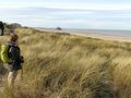
Scopri tutti i vantaggi100 meters away from the sea lies the nature reserve De Fonteintjes, a long and tranquil dune area. This hike takes you there and then along the pier of Blankenberge. A perfect recipe for a sunny day.
-------------------------------------------
Text and photo Mark Dedapper
-------------------------------------------
Between Zeebrugge and Blankenberge lie two beautiful, little-known nature reserves. You start the hike just outside the harbor area of Zeebrugge and soon arrive at De Fonteintjes, a narrow but beautiful dune area. On a nice hiking path, you walk past ponds and can enjoy a diverse plant world, including some rare wild orchids. The turning point of the hike is the pier of Blankenberge, 350 meters long and built in 1933. After a detour over the beach, we head to the Zeebos, which was planted as a green buffer zone between Blankenberge and the harbor of Zeebrugge. At the entrance of the forest, there is a field used by some youth organizations.
------------------------
The Route
-------------------------
Start at the tram stop Zeebrugge Strandwijk. You can park your car in Sint-Christianastraat. Follow Sint-Christianastraat briefly and turn left shortly before the Stella Maris church (2) and immediately right onto the sidewalk along the church entrance. At the T-junction, turn right and immediately left into Adriaan de Gerlachestraat until the Zeedijk - turn left. 400 meters further, turn left into Londenstraat. After 100 m, across from house number 7, turn right into a dune path. You will enter the nature reserve De Fonteintjes (3). Go through a gate and follow the narrow path. Pass another gate on the right along the head of the first pond. At the T-junction of the dune paths, turn left. First path left around a wetland and go past a gate on the right. After a few steps, you go through another gate. You arrive at a broader path, which you follow to the right. After about 400 m, where the main path makes a 90° turn, take the narrower path diagonally right. At the T-junction, turn left. Follow the Zeedijk right to the pier of Blankenberge (4). Turn right up onto the pier until you reach the Dijk again - left back to the dunes. At the end of the Dijk, turn left onto the beach. Turn right around the beach bar and walk across the beach with a view of the cranes of the port of Zeebrugge (2).
After 1 km, turn right over the clear beach crossing. At the information board, turn right and immediately left. At the T-junction, turn left to cross the Kustlaan a few meters further on the right (at the tram stop Duinse Polders). Follow the fairly wide gravel path (also a cycle path) on the right, parallel to the Kustlaan. After 500 m, turn right into the crossroad. You will enter the Zeebos (5). Before the buildings of the youth organizations, turn left. Continue following this path. You walk through a bird observation hut. 50 m later, where the main path turns right, take the narrower path straight ahead. Continue along the edge of the forest with a small canal on your left. About thirty meters before a road, turn right. At the T-junction, take the cycle path right. At the site of the youth organizations, turn right and continue left around the site.
You reach the cycle path (gravel path) again – right. Momentarily left on the asphalt and immediately right parallel to the Kustlaan. At the tram stop Zeebrugge Strandwijk, carefully cross the Kustlaan (no pedestrian crossing) and continue to Sint-Christianastraat for cars.
Hai notato qualcosa su questo itinerario?Aggiungere un problema
Naviga nel percorso in...
![]() App RouteYou Aprire
App RouteYou Aprire
![]()
Attendi, la tua stampa è in preparazione.
La tua stampa è pronta per il download. Buon divertimento in viaggio!
Elaborazione della richiesta non è riuscita. Si prega di riprovare.
<iframe src="https://plugin.routeyou.com/routeviewer/free/?language=it&params.route.id=5908043&params.language=en" width="100%" height="600" frameborder="0" allowfullscreen></iframe>
<p><a class="routeYou_embed" href="https://app.routeyou.com/en-be/route/view/5908043?utm_source=embed&utm_medium=article&utm_campaign=routeshare&navigation=external" title="Nature between Zeebrugge and Blankenberge - RouteYou" target="_blank"><img src="https://image.routeyou.com/embed/route/960x670/5908043-en@2x.png" style="width: 100%; height: auto;" alt="Nature between Zeebrugge and Blankenberge"></a></p>
Altri commenti:
Questa funzionalità è disponibile esclusivamente per gli abbonati a RouteYou PREMIUM.
Prova 1 mese gratis e scopri la differenza! Non prendiamo alcun dettaglio di pagamento e la tua prova termina automaticamente dopo un mese.
© 2006-2026 RouteYou - www.routeyou.com