Azure
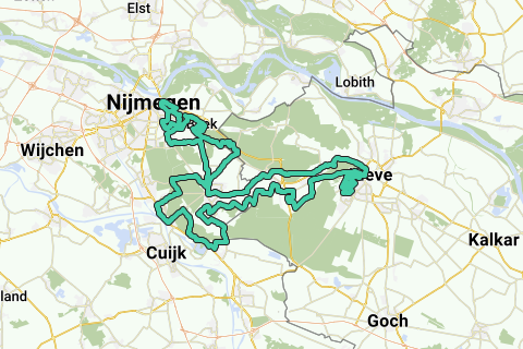
AzureBattle on the Okerheide, about fifty large and smaller climbs in the Kingdom of Nijmegen and the Klever Land. This climbing route has almost 1300 meters of altitude through the wooded hill zone between the two border towns. Already designed in 2011 as Okerkoning and despite the loss of the asphalt on the Brandenberg and Geldenberg in the Reichswald, more than Zwitsalp-neutral further developed. Sledgehammer king, like its newer counterpart Dievelsalt, requires some navigation skills.
-Start at the Tourist Office Berg en Dal
-Dorpsplein 1a, 6562 AH Groesbeek
Hai notato qualcosa su questo itinerario?Aggiungere un problema
Naviga nel percorso in...
![]() App RouteYou Aprire
App RouteYou Aprire
Vuoi smettere di vedere questo annuncio?
→ Upgrade ora
![]()
Attendi, la navigazione è in preparazione.
Ora puoi navigare. Buon divertimento in viaggio!
Elaborazione della richiesta non è riuscita. Si prega di riprovare.
Vuoi smettere di vedere questo annuncio?
→ Upgrade ora
![]()
Attendi, il tuo download è in preparazione.
Il tuo download è pronto. Buon divertimento in viaggio!
Elaborazione della richiesta non è riuscita. Si prega di riprovare.
Vuoi smettere di vedere questo annuncio?
→ Upgrade ora
![]()
Attendi, la tua stampa è in preparazione.
La tua stampa è pronta per il download. Buon divertimento in viaggio!
Elaborazione della richiesta non è riuscita. Si prega di riprovare.
<iframe src="https://plugin.routeyou.com/routeviewer/free/?language=it&params.route.id=286143&params.language=en" width="100%" height="600" frameborder="0" allowfullscreen></iframe>
<p><a class="routeYou_embed" href="https://app.routeyou.com/en-nl/route/view/286143?utm_source=embed&utm_medium=article&utm_campaign=routeshare&navigation=external" title="Climb at Nijmegen Mokerkoning 2011-2018 - RouteYou" target="_blank"><img src="https://image.routeyou.com/embed/route/960x670/286143-en@2x.png" style="width: 100%; height: auto;" alt="Climb at Nijmegen Mokerkoning 2011-2018"></a></p>
Altri commenti:
Questa funzionalità è disponibile esclusivamente per gli abbonati a RouteYou PREMIUM.
Prova 1 mese gratis e scopri la differenza! Non prendiamo alcun dettaglio di pagamento e la tua prova termina automaticamente dopo un mese.
© 2006-2026 RouteYou - www.routeyou.com