176 vues | Publique
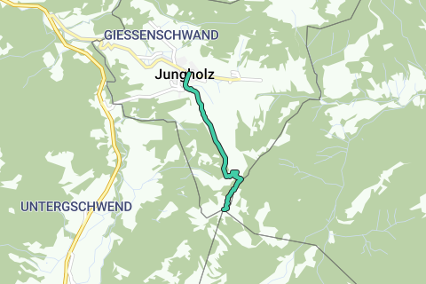
This hike takes you to a unique geographical point in Europe: The summit of the mountain Sorgschrofen (1636 m). The area north of it, called Jungholz, forms an exclave of Austria that is connected to the rest of Austria by a single point, which is the summit of the mountain Sorgschrofen (1636 m). As well as housing border post number 110 on the normal international border between Tyrol and Bavaria, a second border starts and, having gone round Jungholz, ends there. There are thus borders extending in four directions from the summit, called a quadripoint. Two Austrian (Tyrolian, Reutte) and two German (Bavarian, Oberallgäu) municipalities meet at that point.
Parcourir l'itinéraire dans...
![]() Application RouteYou Ouvrez
Application RouteYou Ouvrez
![]()
Veuillez patienter, votre impression est en cours de préparation.
Votre impression est prête à être téléchargée. Amusez-vous en route!
Le traitement de votre requête a échoué. S'il vous plaît réessayez.
![]()
Veuillez patienter, votre téléchargement est en cours de préparation.
Votre téléchargement est prêt. Amusez-vous en route!
Le traitement de votre requête a échoué. S'il vous plaît réessayez.
<iframe src="https://plugin.routeyou.com/routeviewer/free/?language=fr&params.route.id=4325108&params.language=en" width="100%" height="600" frameborder="0" allowfullscreen></iframe>
<a href="https://www.routeyou.com/en-at/route/view/4325108/hiking-route/sorgschrofen-hike-towards-a-quadripoint?utm_source=embed&utm_medium=article&utm_campaign=routeshare" title="Sorgschrofen hike: towards a quadripoint - RouteYou" target="_blank"><img src="https://image.routeyou.com/embed/route/960x670/4325108-en@2x.png" width="960" height="670" alt="Sorgschrofen hike: towards a quadripoint"></a>
Commentaires supplémentaires:
Essayez cette fonctionnalité gratuitement avec un abonnement d'essai RouteYou Plus.
Si vous avez déjà un tel compte, connectez-vous maintenant.
Essayez cette fonctionnalité gratuitement avec un abonnement d'essai RouteYou Premium.
© 2006-2024 RouteYou - www.routeyou.com