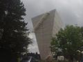
Park in the parking lot near the water tower in front of the forest on sanatoriumlaan. Enter the forest just opposite and immediately follow the path to the right. After about 50 meters, turn left and follow the path that descends to the edge of the forest and turn right. Walk straight out of the forest and take the Dikkemeerweg on the left via about 20m of meadow path.
At the first triple jump, keep left and continue onto J.B. Deneyerstraat on the left.
At the end of this street you have two options: the first road on the right or the second (at the end) the first will be a little smoother and more difficult to walk in rainy but more beautiful weather, the second more accessible in rainy weather and offers a view of the paper mill 'Herisemmolen'.
When you arrive at the Duivelsborren/Steenput T-junction, turn right and then turn left onto the Steenputbeek bridge.
You will climb to the top of the Alsembergsesteenweg! Please note that you are directly on the bike path where you ride in two directions!!
Use the pedestrian crossing provided to cross and walk along the Panoramastraat on the right into the Destelheidestraat.
At the corner of the second street there is a chapel, turn left here. Follow the Zevenbronstraat to the bridge over the Zevenbronbeek (you won't miss this cool green bridge).
Follow the Deuveressenweg (Deuveressen means "devils") to where it connects to the Rilroheide you follow and turn left at the Mariakapel. Keep left and follow Kampendaal to the forest where it turns into Forty Bunderdreef. The Forty Bunderdreef takes you through the Hallebos to Braine-le Château, where the name will change to 'rue Landuydt'. After leaving the forest for about 600m, you arrive at a Y-junction where the left of the house painted white (do not turn left) follow Landuydt Street until you enter the street with the strange name: Blangugue Street on the right.
Take a clockwise walk in the (private) pond through the forest. It is strangely enough the rue des Quarante Bonniers (see Fortybunderbos') which is not connected to this Dutch-speaking variant.
At the end on the left. It is first a street and then a bad road that ends up turning into a very dug path and strewn with thick rocks ... until you enter Flanders again. You arrive at the Vlasmarktdreef, you leave the motorway on the right and go to the left. Here you are exactly halfway down the road, a good time to take a break and have lunch at the kiosk. After your lunch, you continue along the Beukendreef: you can see a blue pole between the grass at the street sign of the Vlasmarktdreef, there is the Beukendreef. you follow the path laterally on the tto motorway at Pijpaenshoek. Do not take the motorway underneath, but keep left and continue your way via Houtveld at the next intersection on the right after the farm driveway. You will continue to the Kasteelstraat which crosses the Warande. Turn right at this intersection.
Cross the E19 and at the next junction turn right into Hallerbosstraat where all other road users are immediately alerted to the presence of walkers.
At the next intersection there is a Maria chapel (it looks like an omegang) on the left in the Kleinheide, then from left to right on the Plattesteen and further along the Kroonlaan which leads us with a winding road to the Winkelaaar. Here you will come across the Steenputbeek Valley Nature Reserve, where Natuurpunt has set up a clarification information panel. A solid sofa beautifully engraved. Here on the hiking trail you eclipse by the trees as long as the fields and fields lead to the lively Alsembergsesteenweg. cross the Steenweg and turn left between the Sint-Barbara chapel and the Gravenhof tavern on the Lotsesteenweg.
After the Gravenhoflaan, at Sint-Rochuskapel, turn left (Hanebosweg) until you return to the Lotsesteenweg. Now cross and follow the road through the field, through the Begijnbos to the Begijnbosstraat here on the right and left and cross the crossroads after the farm straight line (between the two meadows). The small Hertweg offers a beautiful view of the northern part of the Senne valley. It is a difficult road very poorly maintained (especially after a few days of rain). On the Donderveldweg we turn left and after 200 m right, the 'Perreweg' in Here you walk along a stream through the Kesterbeek Marsh Nature Reserve. At the top of the Hoveweg, at the corner of the Klutsstraat is the Natuurpunt information panel. After all this useful information, follow the Klutsstraat eastwards (if you haven't lost your kluts in the meantime...)
After the 'Garden of Disturbances' turn left onto Meigemheidestraat and at the end right follow Sanatoriumstraat where you arrived at the water tower and car park after a 17th century chapel, the Red Cross asylum centre and about 1200m. There is also a bench from where you have a beautiful panoramic view of Brussels.
Naviga nel percorso in...
![]() App RouteYou Aprire
App RouteYou Aprire
Vuoi smettere di vedere questo annuncio?
→ Upgrade ora
![]()
Attendi, la navigazione è in preparazione.
Ora puoi navigare. Buon divertimento in viaggio!
Elaborazione della richiesta non è riuscita. Si prega di riprovare.
Vuoi smettere di vedere questo annuncio?
→ Upgrade ora
![]()
Attendi, il tuo download è in preparazione.
Il tuo download è pronto. Buon divertimento in viaggio!
Elaborazione della richiesta non è riuscita. Si prega di riprovare.
Vuoi smettere di vedere questo annuncio?
→ Upgrade ora
![]()
Attendi, la tua stampa è in preparazione.
La tua stampa è pronta per il download. Buon divertimento in viaggio!
Elaborazione della richiesta non è riuscita. Si prega di riprovare.
Vuoi smettere di vedere questo annuncio?
→ Upgrade ora
![]()
Attendi, il tuo download è in preparazione.
Il tuo download è pronto. Buon divertimento in viaggio!
Elaborazione della richiesta non è riuscita. Si prega di riprovare.
<iframe src="https://plugin.routeyou.com/routeviewer/free/?language=it&params.route.id=2484451&params.language=en" width="100%" height="600" frameborder="0" allowfullscreen></iframe>
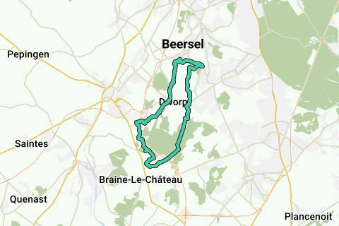
<a href="https://www.routeyou.com/en-be/route/view/2484451/nordic-walking-route/alsemberg-water-tower-loop-of-braine-le-dworp?utm_source=embed&utm_medium=article&utm_campaign=routeshare" title="Alsemberg water tower - loop of Braine-le-Dworp - RouteYou" target="_blank"><img src="https://image.routeyou.com/embed/route/960x670/2484451-en@2x.png" width="960" height="670" alt="Alsemberg water tower - loop of Braine-le-Dworp"></a>
Altri commenti:
Prova questa funzionalità gratuitamente con un abbonamento di prova RouteYou Plus.
Se hai già un tale account, accedi ora.
Prova questa funzionalità gratuitamente con un abbonamento di prova RouteYou Premium.
© 2006-2024 RouteYou - www.routeyou.com