715 visite | Pubblica
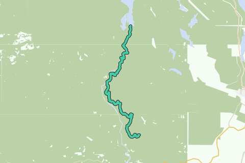
The Sooke Flowline is an abandoned 44-kilometre (27 mi) concrete aqueduct that snakes through the Sooke Hills from Sooke Lake to the Humpback Reservoir near Mt. Wells Regional Park. From this reservoir, a buried, riveted steel pressure main transported water to Victoria. In between 1994 and 2007, this main was replaced since it was long past its useful life. The flowline was vital to the continued growth of the City of Victoria as it provided a reliable water supply.
Inspired by OSM.
Naviga nel percorso in...
![]() App RouteYou Aprire
App RouteYou Aprire
Vuoi smettere di vedere questo annuncio?
→ Upgrade ora
![]()
Attendi, la navigazione è in preparazione.
Ora puoi navigare. Buon divertimento in viaggio!
Elaborazione della richiesta non è riuscita. Si prega di riprovare.
Vuoi smettere di vedere questo annuncio?
→ Upgrade ora
![]()
Attendi, il tuo download è in preparazione.
Il tuo download è pronto. Buon divertimento in viaggio!
Elaborazione della richiesta non è riuscita. Si prega di riprovare.
Vuoi smettere di vedere questo annuncio?
→ Upgrade ora
![]()
Attendi, la tua stampa è in preparazione.
La tua stampa è pronta per il download. Buon divertimento in viaggio!
Elaborazione della richiesta non è riuscita. Si prega di riprovare.
Vuoi smettere di vedere questo annuncio?
→ Upgrade ora
![]()
Attendi, il tuo download è in preparazione.
Il tuo download è pronto. Buon divertimento in viaggio!
Elaborazione della richiesta non è riuscita. Si prega di riprovare.
<iframe src="https://plugin.routeyou.com/routeviewer/free/?language=it&params.route.id=2056690&params.language=en" width="100%" height="600" frameborder="0" allowfullscreen></iframe>
<a href="https://www.routeyou.com/en-ca/route/view/2056690/hiking-route/sooke-flowline?utm_source=embed&utm_medium=article&utm_campaign=routeshare" title="Sooke Flowline - RouteYou" target="_blank"><img src="https://image.routeyou.com/embed/route/960x670/2056690-en@2x.png" width="960" height="670" alt="Sooke Flowline"></a>
Altri commenti:
Prova questa funzionalità gratuitamente con un abbonamento di prova RouteYou Plus.
Se hai già un tale account, accedi ora.
Prova questa funzionalità gratuitamente con un abbonamento di prova RouteYou Premium.
© 2006-2024 RouteYou - www.routeyou.com