Overview:
When arriving in Chandolin you can park your car above the tourist office. This is also the starting point of this hike. The parking spots are not free so don't forget to fill the meter.
At the tourist office you'll find a bunch of yellow signs, we start with following the path to Lac Noir. this path leads us immediately on a ski slope. When crossing the big path we turn right along this path and after 50m turn left, it is marked with a backpacker sign. This small path leads to the first alp or 'Le Premiére Alpage de Chandolin'. Here they make local cheese and for the kids it's also a mini farm in the summer.
But we are here to hike, so we take the backpackers path above the alpage to 'La Grande Remointse', the second alp of Chandolin. We go through the farm as we arrive, following the backpackers path and the white-red-white markings. This path will lead us to Lac Noir and when you arrive early here you can see some wildlife too.
We do not go to the lake itself but it is optional, it is a good resting point but ideally its better to rest at the summit of Arêtes des Ombrintses. So at the crossing point with Lac Noir we follow the big road to the right and keep following it until we reach the end of it. You'll notice that the path gets rougher with more loos rocks.
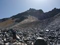
And that's the moment where the path changes abruptly to a big debris field with no more path visible. The key here is to look good on the GPS device and look for big red sticks that stand in the rocks. Those are the key to a good crossing. But be careful, not every stone is steady as a rock! When climbing over all these rocks, do look behind you while you'll get an amazing view on the Illhorn mountain.
Once the debris field has been crossed we have a path again. Still rocky but better than the debris field. The summit is not far away anymore. Once reached you'll get a view on the other side of Arêtes des Ombrintses with view on the Rothorn and Bella Tolla as the nearest mountains, the Toûno mountain chain a bit further and of course the 5 +4000m mountains Cervin, Ober Gabelhorn, Dent Blanche, Grand Cornier, Zinal Rothorn.
From the summit we walk down the ski slope in the direction of Cabane de la Bella Tolla, this is a neat cabane with a very nice view over the Val d'Anniviers. Definitely worth a stop before heading back to Chandolin.
At the Cabane we head to Par. di Modxes, a crossing point between Tignousa, the Cabane and the path to Chandolin. In local terms the path from Par. di Modxes is called "Chemin dificile" or difficult path. Not that it is difficult but it's not an average path. After that, we can see the Chandolin village where we started.
Tips: Hike classification: T3 – Challenging Mountain Hikes
Vertical ascent: 838m
Vertical descent: 828m
Story:
During this hike we wanted to know for sure if it was possible to go to the Arête des Ombrintses, the charts show a bit of path but disappears in a debris field. If it wasn't possible, we wouldn't go further so with that in mind we left Chandolin and headed for the shortest route to the lake Lac Noir.
Lac Noir is reachable when following the path to La Grande Remointse with first passing point at "le premiere alpage de Chandolin". From this farm we take the backpackers route to La grande Remointse followed by Lac Noir.
Once on the big route we followed it for a bit so we reached the red ski slope, in summer it is in fact a hinge debris field from where you'll have to search for the path. Because in the winter it is a ski slope you can find your way with the red sticks in the rocks. Easier said than done but we made it ;-) From this path you'll get some splendid views over the region.
Around noon we reached the summit where we had dinner before heading back to Cabane de la Bella Tolla and further on Par. di Modxes.
Really nice hike with an adventurous piece.
Tips:
- Hike classification: T3 – Challenging Mountain Hikes
- Steady shoes required and good orientation skill.
Parcourir l'itinéraire dans...
![]() Application RouteYou Ouvrez
Application RouteYou Ouvrez
Plus voir cette annonce?
→ Améliorez maintenant
![]()
Veuillez patienter, la navigation est en cours de préparation.
Vous pouvez maintenant naviguer. Amusez-vous en route!
Le traitement de votre requête a échoué. S'il vous plaît réessayez.
Plus voir cette annonce?
→ Améliorez maintenant
![]()
Veuillez patienter, votre téléchargement est en cours de préparation.
Votre téléchargement est prêt. Amusez-vous en route!
Le traitement de votre requête a échoué. S'il vous plaît réessayez.
Plus voir cette annonce?
→ Améliorez maintenant
![]()
Veuillez patienter, votre impression est en cours de préparation.
Votre impression est prête à être téléchargée. Amusez-vous en route!
Le traitement de votre requête a échoué. S'il vous plaît réessayez.
Plus voir cette annonce?
→ Améliorez maintenant
![]()
Veuillez patienter, votre téléchargement est en cours de préparation.
Votre téléchargement est prêt. Amusez-vous en route!
Le traitement de votre requête a échoué. S'il vous plaît réessayez.
<iframe src="https://plugin.routeyou.com/routeviewer/free/?language=fr&params.route.id=2260298&params.language=en" width="100%" height="600" frameborder="0" allowfullscreen></iframe>
<a href="https://www.routeyou.com/en-ch/route/view/2260298/hiking-route/to-the-arete-des-ombrintses-under-the-rothorn?utm_source=embed&utm_medium=article&utm_campaign=routeshare" title="To the Arête des Ombrintses under the Rothorn - RouteYou" target="_blank"><img src="https://image.routeyou.com/embed/route/960x670/2260298-en@2x.png" width="960" height="670" alt="To the Arête des Ombrintses under the Rothorn"></a>
Commentaires supplémentaires:
Essayez cette fonctionnalité gratuitement avec un abonnement d'essai RouteYou Plus.
Si vous avez déjà un tel compte, connectez-vous maintenant.
Essayez cette fonctionnalité gratuitement avec un abonnement d'essai RouteYou Premium.
© 2006-2024 RouteYou - www.routeyou.com