6401 Aufrufe | Öffentlich | Niederländisch
This route is part of the 7 Summits, the seven steepest mountainpeaks in South Limburg. It is a circular walk of 8.5 km with a maximum height of 209 meters. The Sint Brigida pine near the church is a good landmark, because Noorbeek is well hidden in a valley. In 1634, the inhabitants promised Saint Brigida to place a pine in front of her chapel every year, if the cattle disease that plagued Noorbeek and its surroundings disappeared. The cattle disease disappeared and the cattle were spared - and since then people have kept true to this promise.
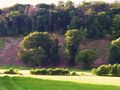
Noorbeek was for a long time part of the County of Dalhem with the capital 's Gravenvoeren on the other side of the mountain. The river Noor that rises here flows via Altembrouck Castle to Belgium where it flows into the Voer. But the direct route to 's Gravenvoeren runs over the Kattenroth, a mountain ridge that forms the border here. Climb this summit from the church in Noorbeek and descend on the south side. You immediately feel like you're abroad.
In winter, low-hanging patches of fog can envelop the summit in mists, but in good weather you can overlook the entire Voer region.
Please note that this route is not signposted.
If you have any comments about the route, you can report them via routepunt@visitzuidlimburg.nl.
A booklet of the 7 Summits or a complete hiking map with many dozens of other hiking trails in this region can easily be ordered via www.visitzuidlimburg.nl/webshop .
Route navigieren in...
![]() RouteYou-App Öffnen
RouteYou-App Öffnen
Diese Werbung nicht mehr anzeigen?
→ Jetzt upgraden
![]()
Bitte warten Sie, die Navigation wird vorbereitet.
Sie können jetzt navigieren. Viel Routen-Spaß!
Bearbeitung Ihrer Anfrage ist fehlgeschlagen. Bitte versuchen Sie es erneut.
Diese Werbung nicht mehr anzeigen?
→ Jetzt upgraden
![]()
Bitte warten Sie, Ihr Download wird vorbereitet.
Ihr Download ist fertig. Viel Routen-Spaß!
Bearbeitung Ihrer Anfrage ist fehlgeschlagen. Bitte versuchen Sie es erneut.
Diese Werbung nicht mehr anzeigen?
→ Jetzt upgraden
![]()
Bitte warten Sie, Ihr Ausdruck wird vorbereitet.
Ihr Ausdruck ist bereit für den Download. Viel Routen-Spaß!
Bearbeitung Ihrer Anfrage ist fehlgeschlagen. Bitte versuchen Sie es erneut.
Diese Werbung nicht mehr anzeigen?
→ Jetzt upgraden
![]()
Bitte warten Sie, Ihr Download wird vorbereitet.
Ihr Download ist fertig. Viel Routen-Spaß!
Bearbeitung Ihrer Anfrage ist fehlgeschlagen. Bitte versuchen Sie es erneut.
<iframe src="https://plugin.routeyou.com/routeviewer/free/?language=de&params.route.id=8174145&params.language=en" width="100%" height="600" frameborder="0" allowfullscreen></iframe>
<a href="https://www.routeyou.com/en-nl/route/view/8174145/recreational-walking-route/7-summits-kattenroth-hiking-trail?utm_source=embed&utm_medium=article&utm_campaign=routeshare" title="7 Summits Kattenroth Hiking Trail - RouteYou" target="_blank"><img src="https://image.routeyou.com/embed/route/960x670/8174145-en@2x.png" width="960" height="670" alt="7 Summits Kattenroth Hiking Trail"></a>
Zusätzliches Feedback:
Probieren Sie diese Funktionalität kostenlos mit einem RouteYou Plus-Probeabonnement.
Wenn Sie bereits ein solches Konto haben, melden Sie sich jetzt an.
Probieren Sie diese Funktionalität kostenlos mit einem RouteYou Premium-Probeabonnement.
Wenn Sie bereits ein solches Konto haben, melden Sie sich jetzt an.
© 2006-2024 RouteYou - www.routeyou.com