743 Aufrufe | Öffentlich
This kayak tour has been designed to introduce you to the riverside life of one of the very last canals on the main land of the City of Ayutthaya, which is still in good condition and although silted, not yet filled up as such was the fate of most of the canals on the city island.
Khlong Hantra or like Cushman would translate it, the "Canal of the Division of the Seal" flows through the sub-district of the same name (Tambon Han Tra), formerly referred to as the Hantra Plains. This canal was once a stretch of the Pa Sak River, meandering around the former Ban Ma (Horse village), east of Ayutthaya. When the latter was deviated towards the Front city moat at some stage, the old riverbed, was divided up in different canals being: Khlong Hantra (from Wat Pa Kho till Wat Krasang), Khlong Kramang (from Wat Krasang till the entry of Khlong Dusit), Khlong Dusit (called after Wat Dusitaram on its west bank) and Khlong Khao San (with its mouth at the present Pa Sak River, being the southern end of the former Front city moat).
Khlong Hantra is one of the most important former canals, east of Ayutthaya, bordering the ancient Ayodhya area. Ayodhya covered parts of the present Phai Ling, Hantra and Khlong Suan Phlu sub-districts. The area was probably already populated during the Dvaravati era (6th to the 11th centuries). Sources suggest that the Khmers occupied the area as early as 850-1000 AD and established an outpost here, naming it Ayodhya after the ancient and one of the holiest Hindu cities of India (the old capital of Awadh in the Faizabad district of Uttar Pradesh). The area was later invaded by Anawrahta, the King of Pagan (r.1044-1077) and controlled by the "Burmese"; for about a hundred years. After the Burmese influence waned, it was conquered once again by the Khmer and held until the mid 13th century. The Tai seized political power shortly afterward by combining the Lavo and Suphannaphum Kingdoms.
There is evidence that a community settled in this area much earlier than 1351 - the official date of establishment of the city of Ayutthaya. Chinese merchants set up an important commercial center in this area for conducting trade with the Sukhothai kingdom. This area was originally connected to the city island, since the Pa Sak River had yet to be deviated for defensive and navigational purposes. However, the boundaries of the ancient city are still subject of debate. When King U-Thong arrived at Wiang Lek in 1347, as thus a number of architectural structures already existed.
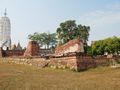
Khlong Hantra houses three active Buddhist monasteries: Wat Pa Kho at its mouth on the southern canal bank, Wat Hantra on its eastern bank and Wat Krasang at its confluence with Khlong Kramang Phai Ling. The Hantra Field played also a role in Ayutthaya's defenses, as it was one of the areas where a large wooden fort - the Thong Na Hantra Fort - was built. In 1581 the Hantra plains were used to constitute a Siamese army of 100.000 soldiers, 800 elephants and 1500 horses to prepare an attack on the Cambodian capital of Lawaek. The campaign was not successful as the City of Lawaek did not surrender and the Siamese army had to give up its siege, due to insufficient food supplies. It was also in this area that Phraya Tak, the later King Taksin, with his followers broke through the Burmese encirclement of Ayutthaya at Hantra Village in 1766.
The tour will take 3-4 hours according to your level of physical fitness, the conditions of the water current, and your personal kayaking experience. Highlights are listed to give you a number of reference points on this tour itinerary. Travel time will expand if you stop to visit every highlight listed on this tour itinerary. Nevertheless, we have listed a few extra sites for the sake of smoother navigation and to alert kayakers to possible locations for obtaining water and other supplies. Individual kayakers can choose where to stop according to their own tastes and time constraints.
If you are interested in viewing photographs of the temples in advance or would like additional historic information about these monasteries, visit our website at www.ayutthaya-history.com.
Tips and Warnings
The only location in Ayutthaya, which offers kayaks for rent is “The Seven Seas Riverside Ayutthaya”, located along U-Thong Road (Soi 19) and near Khlong Chakrai Yai and the Somdet Phra Sri Nakharin Park. The small hotel has kayaks available for renting to tourists. As thus, the starting point of this kayak tour begins at “The Seven Seas Riverside Ayutthaya”.
Be aware that from time to time Khlong Hantra could be clogged up by water hyacinth, making paddling difficult or even impossible. It is not possible to predict such a blockage, as it depends mainly on the swift action of the local authorities in regular maintaining the waterway and keeping it open for navigation. Water hyacinths are a reoccurring problem on virtually every river and canal in Thailand.
Ayutthaya, although located far away from the Gulf of Thailand, is still under tidal influence. The Pa Sak River at Ayutthaya is thus a tidal river, causing the river to shift direction once a day. The tidal action is predictable. A tidal table of Bangkok can be found at http://www.mobilegeographics.com:81/locations/362.html (add 7 hours to the Bangkok local time). It may be useful to adjust your itinerary in function of these shifting currents and do some of the kayaking routes in reverse if missing stamina.
Be aware for whirlpools and heavy current at the confluence of the Pa Sak and Chao Phraya River in front of Phet Fortress and between Ko Loi - Ayutthaya Boat Building School and the eastern Pa Sak River bank, especially during the second part of the rainy season (September – November). In normal months, stick close to eastern Pa Sak river bank; From September to November stick to the western Pa Sak River bank. Stick south close to Wat Phanan Choeng when crossing the Chao Phraya River confluence with the Pa Sak River. Wear a life jacket and hook up your equipment!
Protect you from sunshine. Wear a hat, sun-glasses and loose-fitting clothing that covers arms and legs. Use sun blocker on exposed parts of the body. It is important to bring a large bottle of water aboard.
On the water, exercise caution!
Who are we?
Ayutthaya Historical Research [AHR] consists of a small group of researchers/writers with the aim to promote Ayutthaya’s cultural heritage. We are local expatriates who have been living in Ayutthaya for many years and would like to share our knowledge with future visitors. Therefore, we have personally tested each of these suggested routes by cycling and/or walking. More information on the authors can be found at: http://www.ayutthaya-history.com/Authors.html
In case of emergency or accident
Contact the Ayutthaya Tourist Police Station: (035) 241-446, (035) 242-352 or 1155.
Disclaimer
AHR will not be held liable for any loss or damage whatsoever for any suggestions made in relation to the site’s promotion of ecotourism. It is the responsibility of the user of the site to take the necessary precautions to avoid any physical injury, traffic incident, animal attack, theft, and damage to equipment. Any reliance on the site’s information is therefore strictly at your own risk. Read our full disclaimer at website www.ayutthaya-history.com
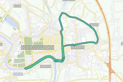
The route
Historical signboard in situ is marked as (*)
Entry fee required is marked as ($)
Boat dock present marked as (+)
©2010-2020 Ayutthaya Kayaking Experience
All rights reserved.
Datenquelle: Ayutthaya Kayaking Experience
Route navigieren in...
![]() RouteYou-App Öffnen
RouteYou-App Öffnen
Diese Werbung nicht mehr anzeigen?
→ Jetzt upgraden
![]()
Bitte warten Sie, die Navigation wird vorbereitet.
Sie können jetzt navigieren. Viel Routen-Spaß!
Bearbeitung Ihrer Anfrage ist fehlgeschlagen. Bitte versuchen Sie es erneut.
Diese Werbung nicht mehr anzeigen?
→ Jetzt upgraden
![]()
Bitte warten Sie, Ihr Download wird vorbereitet.
Ihr Download ist fertig. Viel Routen-Spaß!
Bearbeitung Ihrer Anfrage ist fehlgeschlagen. Bitte versuchen Sie es erneut.
Diese Werbung nicht mehr anzeigen?
→ Jetzt upgraden
![]()
Bitte warten Sie, Ihr Ausdruck wird vorbereitet.
Ihr Ausdruck ist bereit für den Download. Viel Routen-Spaß!
Bearbeitung Ihrer Anfrage ist fehlgeschlagen. Bitte versuchen Sie es erneut.
Diese Werbung nicht mehr anzeigen?
→ Jetzt upgraden
![]()
Bitte warten Sie, Ihr Download wird vorbereitet.
Ihr Download ist fertig. Viel Routen-Spaß!
Bearbeitung Ihrer Anfrage ist fehlgeschlagen. Bitte versuchen Sie es erneut.
<iframe src="https://plugin.routeyou.com/routeviewer/free/?language=de&params.route.id=189962&params.language=en" width="100%" height="600" frameborder="0" allowfullscreen></iframe>
<a href="https://www.routeyou.com/en-th/route/view/189962/canoe-kayak-route/ayutthaya-khlong-hantra-kayak-track?utm_source=embed&utm_medium=article&utm_campaign=routeshare" title="Ayutthaya - Khlong Hantra Kayak Track - RouteYou" target="_blank"><img src="https://image.routeyou.com/embed/route/960x670/189962-en@2x.png" width="960" height="670" alt="Ayutthaya - Khlong Hantra Kayak Track"></a>
Zusätzliches Feedback:
Probieren Sie diese Funktionalität kostenlos mit einem RouteYou Plus-Probeabonnement.
Wenn Sie bereits ein solches Konto haben, melden Sie sich jetzt an.
Probieren Sie diese Funktionalität kostenlos mit einem RouteYou Premium-Probeabonnement.
Wenn Sie bereits ein solches Konto haben, melden Sie sich jetzt an.
© 2006-2024 RouteYou - www.routeyou.com