276 vues | Publique
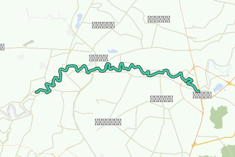
This kayak track is the third track of the Lower Pa Sak River and is part of the Pa Sak River Project set up by Ayutthaya kayaking Experience [AKE] aiming to make the necessary pre-arrangements in order to execute a 15-day long kayak trip from the source of the Pa Sak River high in the Phetchabun Mountain Range in Loei Province until its confluence with the Lopburi River, northeast of Ayutthaya and before it runs into the Chao Phraya River in the southeast of the city near Wat Phanang Choeng (Thailand).
The Pa Sak River, translated the "Teak Forest River", a major tributary of the Chao Phraya River, draining borderlands on the eastside of the Central Plain, finds its source in the highlands of Phetchabun Province and flows for hundreds of kilometers through the central plains of the Lopburi and Saraburi provinces, to join the Chao Phraya River at Ayutthaya.
The river descends from the mountainous north in Dan Sai District of Loei Province (1,746 m) to the south reaching its lowest point (3 m) in Uthai District of Ayutthaya Province. Short tributaries from the east and the west, join the river on its course to the Chao Phraya. Tributaries of the Pa Sak include: Lam Muak Lek (Muak Lek) , Huai Nam Phung (Ban Hin Hao), Huai Pa Daeng (Ban Pa Daeng), Lam Kong (Ban Wang Tha Di), Lam Sonthi (Ban Tha Yiam & Ban Na Som), Huai Wang Chomphu (Ban Wang Chomphu), Huai Na (Ban Huai Na), Huai Nam Chun (Ban Fai Wang Bon), Huai Nam Duk (Ban Pak Chong), Huai Khon Kaen (Ban Wang Khon Du), Huai Yai (Ban Sakae Ngam), Huai Saduang Yai (Ban Thai Bun), Khlong Ban Bong (Ban Chaliang Lap), Huai Yai (Ban Huai Yai Nua), Huai Tarang (Ban Huai Yai Nua), Huai Yai (Ban Hin Dat), Huai Lam Narai (Ban Lam Narai), Lam Kot Thong (Ban Lam Kot Thong) and Lam Phaya Klang (Ban Pang Hu Sua). Main cities along the Pa Sak River are Phetchabun, Saraburi and Ayutthaya.
The Pasak River includes both the central alluvial plain and North-east plateau and is divided into nine sub-basins. The river basin contains both urban and agricultural areas with the water resource being utilized mainly for paddy irrigation.
This tour takes you from the city of Saraburi to a locality called Wang Daeng. It is a very long kayak trip estimated at 9 hours of paddling including some short breaks. The track is littered with Buddhist monasteries on the east and west banks of the river. The river current will be either very slow or none (with an exception in the rainy season), due to the water regulation from the Rama VI Barrage at Tha Luang. The dam is a point of interest as it was the first large water gate constructed in Siam, in order to improve irrigation in the Lower Chao Phraya basin.
Fish farming starts near Wat Tanod in Dao Rueang sub-district. Reaching Tha Luang, we arrive at the Rama VI barrage and as thus a kayak obstacle. The kayak needs to be taken out of the water and transported to the other side of the dam; an operation which takes about half an hour. Once passed the Rama VI Dam, we encounter the first large barges, left and right at their mooring sites near the factories along the waterway. We start to enter a more industrialized area, but are also close to the end of this track.
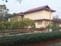
Tha Rua was known as a stopover for the Ayutthayan Kings on their visit to the Phra Phutthabat. From here they changed their barges for elephants, in order to continue by land to the Satchaphantkakiri Hill, where the Footstep of the Buddha was discovered.
Tips and Warnings
General - Stock up supplies of water (500 ml/hr), electrolyte beverages (3-4 bottles) and dry food (take a snack every 2 hours) as there is not much opportunity to find a meal on this itinerary. Keep up mobile communications with somebody for emergency cases and do know where you are exactly at all times. Protect your equipment with waterproof bags and tie everything to the boat.
Water currents - The most important variable for making kayaking plans is water current. Rainy season will result in flooding and/or rapidly moving water. Use caution when the current is fast and wear a life jacket.
Clothing - Wear a good hat and loose-fitting clothing that dries quickly. Long pants and shirts with long sleeves may be useful and appropriate to protect you from the sun. The refracted sunlight from the water makes sunburn commonplace, so put on plenty of sun block on not covered parts of your body and wear sunglasses.
Who are we?
Ayutthaya Kayaking Experience [AKE] is a sportive subsidiary from Ayutthaya Historical Research. AKE’s objective is to promote kayaking tourism in Ayutthaya, by basically showing kayak presence on canals and rivers. Kayaking is the perfect outdoor recreation to explore the city island contours and its surroundings. We are local expatriates who have been living in Ayutthaya for many years and would like to share our kayak knowledge with other sportsmen. More information on AKE can be found at: http://aykaex.yolasite.com/
Disclaimer
Ayutthaya Historical Research and Ayutthaya Kayaking Experience will not be held liable for any loss or damage whatsoever for any suggestions made in relation to the site’s promotion of ecotourism. It is the responsibility of the user of the site to take the necessary precautions to avoid any physical injury, traffic incident, animal attack, theft, and damage to equipment. Any reliance on the site’s information is therefore strictly at your own risk. Read our full disclaimer at website www.ayutthaya-history.com.
©2009-2016 Ayutthaya Kayaking Experience
All rights reserved.
Parcourir l'itinéraire dans...
![]() Application RouteYou Ouvrez
Application RouteYou Ouvrez
Plus voir cette annonce?
→ Améliorez maintenant
![]()
Veuillez patienter, la navigation est en cours de préparation.
Vous pouvez maintenant naviguer. Amusez-vous en route!
Le traitement de votre requête a échoué. S'il vous plaît réessayez.
Plus voir cette annonce?
→ Améliorez maintenant
![]()
Veuillez patienter, votre téléchargement est en cours de préparation.
Votre téléchargement est prêt. Amusez-vous en route!
Le traitement de votre requête a échoué. S'il vous plaît réessayez.
Plus voir cette annonce?
→ Améliorez maintenant
![]()
Veuillez patienter, votre impression est en cours de préparation.
Votre impression est prête à être téléchargée. Amusez-vous en route!
Le traitement de votre requête a échoué. S'il vous plaît réessayez.
Plus voir cette annonce?
→ Améliorez maintenant
![]()
Veuillez patienter, votre téléchargement est en cours de préparation.
Votre téléchargement est prêt. Amusez-vous en route!
Le traitement de votre requête a échoué. S'il vous plaît réessayez.
<iframe src="https://plugin.routeyou.com/routeviewer/free/?language=fr&params.route.id=293090&params.language=en" width="100%" height="600" frameborder="0" allowfullscreen></iframe>
<a href="https://www.routeyou.com/en-th/route/view/293090/canoe-kayak-route/saraburi-wang-daeng-kayak-track?utm_source=embed&utm_medium=article&utm_campaign=routeshare" title="Saraburi - Wang Daeng Kayak Track - RouteYou" target="_blank"><img src="https://image.routeyou.com/embed/route/960x670/293090-en@2x.png" width="960" height="670" alt="Saraburi - Wang Daeng Kayak Track"></a>
Commentaires supplémentaires:
Essayez cette fonctionnalité gratuitement avec un abonnement d'essai RouteYou Plus.
Si vous avez déjà un tel compte, connectez-vous maintenant.
Essayez cette fonctionnalité gratuitement avec un abonnement d'essai RouteYou Premium.
© 2006-2024 RouteYou - www.routeyou.com