18 visites | Pública | Alemany • Francès • Neerlandès
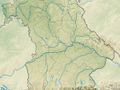
From the train station in Huglfing, the route initially follows a flat path along the railroad tracks in a north-westerly direction. However, the steep ascent through the Oberhausen district of Berg soon begins and only ends at St. Michael's Church, which towers high above the surrounding countryside. Here you can enjoy a magnificent view of the Hoher Peißenberg. Between Berg and Huglfing, a first-class panoramic route awaits walkers. The path leads directly towards the Bavarian Alps, always slightly downhill - past the pilgrimage church of St. Johann - into the village. Barely used asphalt roads now lead hikers along idyllic meadows and moorland to the west before making a small loop across open fields back to Oberhausen.
Further information and links: Signposting: No. 61, red
Pfaffenwinkel hiking map, scale 1:40,000, HW-Verlag, nominal fee EUR 1, available from the Pfaffenwinkel tourist office, www.pfaffen-winkel.de
Has vist alguna cosa en aquesta ruta?Afegir un problema
Navega per la ruta a...
![]() Aplicació RouteYou Obriu
Aplicació RouteYou Obriu
Deixar de veure aquest anunci?
→ Millorar ara
![]()
Espereu, s'està preparant la navegació.
Ara pots navegar. Diverteix-te a la carretera!
Processament de la sol·licitud ha fracassat. Si us plau, torneu a intentar.
Deixar de veure aquest anunci?
→ Millorar ara
![]()
Espereu, s'està preparant la teva descàrrega.
La teva descàrrega està llesta. Diverteix-te a la carretera!
Processament de la sol·licitud ha fracassat. Si us plau, torneu a intentar.
Deixar de veure aquest anunci?
→ Millorar ara
![]()
Espereu, s'està preparant la teva impressió.
La teva impressió està llesta per descarregar. Diverteix-te a la carretera!
Processament de la sol·licitud ha fracassat. Si us plau, torneu a intentar.
<iframe src="https://plugin.routeyou.com/routeviewer/free/?language=ca&params.route.id=14130921&params.language=en" width="100%" height="600" frameborder="0" allowfullscreen></iframe>
<p><a class="routeYou_embed" href="https://app.routeyou.com/en-de/route/view/14130921?utm_source=embed&utm_medium=article&utm_campaign=routeshare&navigation=external" title="Durch Berg und Tal - RouteYou" target="_blank"><img src="https://image.routeyou.com/embed/route/960x670/14130921-en@2x.png" style="width: 100%; height: auto;" alt="Durch Berg und Tal"></a></p>
Feedback adicional:
Aquesta funció està disponible únicament per als subscriptors de RouteYou PREMIUM.
Prova-ho gratuïtament durant 1 mes i descobreix la diferència. No demanem dades de pagament i es desactiva automàticament després del període de prova d'un mes.
© 2006-2026 RouteYou - www.routeyou.com