972 visite | Pubblica
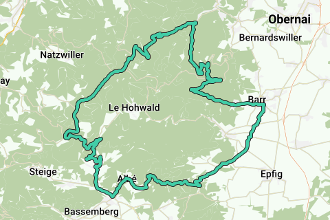
Très beau tour, non seulement pour ses 2 dernières ascensions mais aussi pour ses descentes rapides mais peu dangereuses.
La première ascension se fait sur une route forestière en mauvais état. Après 1/3 de la descente qui suit, la route est en bon état.
--------------------------------------
Montée vers Le Champ du Feu :
Dénivelé : 1099 - 286 = 813 m
Distance : 31,8 - 19,7 = 12,1 km
Pourcentage : 6,7 %
-------------------------------------
Dénivelé total :
1572 m d'après l'onglet "Statistiques"
1695 m d'après mon GPS
-------------------------------------
Parking : 48.405027, 7.455957
-------------------------------------
En cas d'épuisement, retour par la D130 qui est plus plate.
Hai notato qualcosa su questo itinerario?Aggiungere un problema
Naviga nel percorso in...
![]() App RouteYou Aprire
App RouteYou Aprire
Vuoi smettere di vedere questo annuncio?
→ Upgrade ora
![]()
Attendi, la navigazione è in preparazione.
Ora puoi navigare. Buon divertimento in viaggio!
Elaborazione della richiesta non è riuscita. Si prega di riprovare.
Vuoi smettere di vedere questo annuncio?
→ Upgrade ora
![]()
Attendi, il tuo download è in preparazione.
Il tuo download è pronto. Buon divertimento in viaggio!
Elaborazione della richiesta non è riuscita. Si prega di riprovare.
Vuoi smettere di vedere questo annuncio?
→ Upgrade ora
![]()
Attendi, la tua stampa è in preparazione.
La tua stampa è pronta per il download. Buon divertimento in viaggio!
Elaborazione della richiesta non è riuscita. Si prega di riprovare.
<iframe src="https://plugin.routeyou.com/routeviewer/free/?language=it&params.route.id=2439456&params.language=fr" width="100%" height="600" frameborder="0" allowfullscreen></iframe>
<p><a class="routeYou_embed" href="https://app.routeyou.com/fr-fr/route/view/2439456?utm_source=embed&utm_medium=article&utm_campaign=routeshare&navigation=external" title="Autour du Hohwald - RouteYou" target="_blank"><img src="https://image.routeyou.com/embed/route/960x670/2439456-fr@2x.png" style="width: 100%; height: auto;" alt="Autour du Hohwald"></a></p>
Altri commenti:
Questa funzionalità è disponibile esclusivamente per gli abbonati a RouteYou PREMIUM.
Prova 1 mese gratis e scopri la differenza! Non prendiamo alcun dettaglio di pagamento e la tua prova termina automaticamente dopo un mese.
© 2006-2026 RouteYou - www.routeyou.com