Dank unseres Partners Pasar vzw erhältst Du kostenlosen Zugang zu dieser Route - UND Du lernst RouteYou PLUS kennen.
Entdecke alle Vorteile4853 Aufrufe | Öffentlich | Englisch • Französisch • Niederländisch
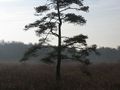
Termin an het Besucherzentrum von Landschaft De Liereman in Oud-Turnhout (V). Natuurpunt hat 6 beschilderte Wanderwege ausgewählt, die in einem kleinen Führer (2 EUR) zusammengefasst wurden. Während dieser Wanderung kombinierst du 5 dieser Wanderungen und gehst ausschließlich über unbefestigte Wege. Bei Regenwetter sind Gummistiefel empfehlenswert. Du startest mit dem Rücken zum Besucherzentrum und folgst eine Weile dem roten Quadrat des Echelkuilpades und dem grünen Rautenmuster des Lieremanpades. Lass die deutsche Straße rechts liegen und biege an der Gabelung mit der Ruhebank von Natuurpunt nach links ab. Entlang des Waldes und an einer Wiese rechts durch ein Sasje. Überquere einen Bach und gehe in den Wald hinein. Du wanderst kurz neben der Aa. An der Stelle, wo sie einen rechten Winkel nach links macht, gehst du geradeaus. Links ein Acker, rechts ein Naturschutzgebiet. Du gehst wieder in den Wald und bleibst an einer Allee, wo die Wanderer des Lieremanpades nach links abbiegen müssen, und gehst geradeaus auf dem schmalen Weg. Ein Stück weiter gehst du durch eine Wiese. Rechts, zwischen den Bäumen, siehst du das Haus der Familie Misonne, früher Eigentümer dieses 20 ha großen Naturschutzgebiets. Du gehst entlang des Ufers des Echelkuil und ziehst dann (ein Stück vor dem Ende des Teichs!) wieder in den Wald hinein. Dies ist ein feuchtes Gebiet. Du wanderst über einen Knüppelpadt, überquerst die Hertenkuilloop und gehst unter anderem zwischen dem wilden Gagel, der im Gageleer, dem Bier von Natuurpunt, verarbeitet wird. An der T-Kreuzung mit dem quer verlaufenden Knüppelpadt biege nach rechts ab. Das Lieremanpad vereinigt sich wieder mit dem Echelkuilpad. Du gehst weiter über einen breiten Streifen mit Bäumen und Sträuchern, der das Naturschutzgebiet von den landwirtschaftlichen Flächen abschirmt. An einer Erdgasleitung (Nummer 116A) gehst du rechts durch ein Sasje und wanderst über einen Weg mit rechts Besenheide und Glockenheide. Danach gehst du zwischen dem Schilfrohr über einen Knüppelpadt und überquerst die Lieremanloop. Der Damm auf der linken Seite ist wichtig für die Wasserwirtschaft im Naturschutzgebiet. Geh weiter bis zu einem breiten Sandweg, dem Lieremanweg. Unsere Wanderung geht hier links ab, aber es lohnt sich, zuerst 200 m nach rechts zu gehen, um dort den Aussichtsturm 1 zu besteigen für einen wunderbaren Blick über das Naturschutzgebiet. Folge danach dem Lieremanweg in entgegengesetzter Richtung des Duinenpades, vorbei an der Kempense Stal 2 und in den Wald. Ignoriere rechts die Hoge Mierdse Heide und folge den orangen Dreieckchen des Korhaanpades. Lass die Arendonkse Liniedijk links liegen und gehe weiter bis zur T-Kreuzung. 100 m links liegt die Vogelbeobachtungsplattform 3 des Naturschutzgebiets De Braekeleer. Unsere Wanderung geht rechts ab. Du wanderst durch ein Wiesen-Vogelgebiet an der Grenze von Arendonk und Oud-Turnhout. Überquere die Brakeleerloop und drehe an der Waldrand links ab. Folge dem breiten Waldweg, bis du rechts in den Wald einbiegen kannst. Wenn du herauskommst, stehst du vor einem abgeholzten Stück Wald, wo Wiederherstellung von Heide betrieben wird. Du gehst sozusagen wörtlich um dieses Gebiet zurück zu dem breiten Sandweg, den du gerade verlassen hast. Folge diesem nach links, bis du rechts an einem Stück vorbeikommst, wo ebenfalls an Heidewiederherstellung gearbeitet wird, bis zu einem breiten Sandweg gehen kannst. Überquere diesen und gehe in einen Waldweg. An einer Ruhebank nimmst du den ersten Weg links. Das Korhaanpad geht hier geradeaus. Jetzt folgst du wieder dem Duinenpad in entgegengesetzter Richtung. An der T folgst du dem Drahtzaun des Naturschutzgebiets nach links. Der Weg folgt dem Zaun nach rechts und du kommst auf einen breiten Sandweg mit Radweg: die Oude Bergweg. Folge diesem geradeaus, in Richtung Besucherzentrum. Achte dann gut auf. Neben dem Radweg siehst du einen Pfosten mit auf der Rückseite dem braunen Kreuz des Vennenpades. Nimm dann den ersten Waldweg links und folge dem Vennenpad in entgegengesetzter Richtung, bis zum Endpunkt, noch etwa 300 bis 400 m. Halte dabei die Pfosten im Auge und gehe weiter bis zum Besucherzentrum. Abgeschlossen werden kann mit einem Gageleer.
Ist Ihnen auf dieser Route etwas aufgefallen?Problem hinzufügen
Route navigieren in...
![]() RouteYou-App Öffnen
RouteYou-App Öffnen
![]()
Bitte warten Sie, Ihr Ausdruck wird vorbereitet.
Ihr Ausdruck ist bereit für den Download. Viel Routen-Spaß!
Bearbeitung Ihrer Anfrage ist fehlgeschlagen. Bitte versuchen Sie es erneut.
<iframe src="https://plugin.routeyou.com/routeviewer/free/?language=de&params.route.id=5367060" width="100%" height="600" frameborder="0" allowfullscreen></iframe>
<p><a class="routeYou_embed" href="https://app.routeyou.com/de-be/route/view/5367060?utm_source=embed&utm_medium=article&utm_campaign=routeshare&navigation=external" title="In der Liereman - RouteYou" target="_blank"><img src="https://image.routeyou.com/embed/route/960x670/5367060-de@2x.png" style="width: 100%; height: auto;" alt="In der Liereman"></a></p>
Zusätzliches Feedback:
Diese Funktion ist ausschließlich für RouteYou PREMIUM-Abonnenten verfügbar.
Testen Sie 1 Monat kostenlos und entdecken Sie den Unterschied! Wir erfassen keine Zahlungsdaten und Ihre Testversion endet automatisch nach einem Monat.
© 2006-2025 RouteYou - www.routeyou.com