Gràcies al nostre soci Pasar vzw, pots accedir gratuïtament de franc a aquesta ruta I familiaritzar-te amb RouteYou PLUS.
Descobreix-ne tots els avantatges1893 visites | Pública | Alemany • Francès • Neerlandès
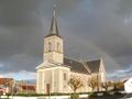
 Azure
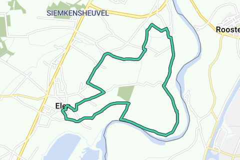
AzureElen is located on the N78 between Maaseik and Dilsen-Stokkem, of which it is a borough. On the church square (V) you can park and get started. Between the church and café In de Gouden Ster you walk west into the Bergerkampstraat. Then you choose the first left, the Laakstraat, and at the T again on the left, the Zonnestraat. Crossroads with the Langstraat and past a large farm you walk into the flat fields. At a fruit plantation you reach the new winter dike. There is a slow road for cyclists and walkers that you follow to the left. Ignore the fork further on the left and stay on the dike until km-marker no. 0.0 1 with the rest benches. There you descend on the right the earth road to the Maas. Southwards you can see the youngest gravel pits in the making. The Meuse bend of Elen is widened here to prevent flooding. The Meuse is a restless rain river that has moved its bed countless times in recent centuries. She once supplied masses of gravel from the Ardennes. She deposited that here, where the flow slows down, in meter-thick layers. Afterwards, she cut deep windings through these gravel banks, which were mined everywhere. A fascinating landscape of floodplains with old river arms, old dikes, embankments, stream channels and loam and clay deposits. On the banks of the Meuse you get beautiful views to both sides and you swing to the left. A gravel road of course, since you walk over gravel banks. First you walk past a lonely house on the Pastoorsdijk. This older winter dike was built in the middle of the 18th century. A few kilometers further you come to a second house, Den Damiaan 2. That used to be a fence for skippers and for the horses that towed the boats upstream. An ingenious dike system protects - and insulates - the house in the event of flooding. A measuring pole indicates the level and years of the latest high water levels. With the one from 1993, you even go head-to-head in this place. Today, the Meuse is unnavigable from Maastricht. For shipping, the Juliana Canal was dug on Dutch territory in 1932. At Bed and Breakfast De Klaproos you come back to the winter dike, which you follow to the right. He takes you to the flagged pilgrimage village of Heppeneert 3, dedicated to Our Lady of Tranquility. With shop, candle gallery, prayer garden, toilets and two inns. On your right, behind the retaining wall, the most beautiful floodplains of the region ripple, speckled with grazing cattle. You continue until past the last house (no. 1) and then turn left into a road, which immediately turns right into the meadows bend. In that bend you can see remains of an old retaining wall, with slots for a bulkhead beam. In the north peaks the green church spire of Maaseik. At the field intersection, take the grass road on the left and at the T with oak again turn left. At the end of the grass road you come to a T on asphalt. Here you make a zigzag left / right and you are at the Zanderbeek, embedded in the green. So follow the field road to the right along the green strip. At the first exit on the left is Duivelsbrugske 4. The corresponding legend of Riddart, the Card Knight, is told on a board. You also came across the story at the village fountain of Heppeneert. Continue straight ahead and follow the Zanderbeek until you reach the asphalt of the Zandstraat. Turn left there. First ignore the Diepbeekweg and then the Keizerskamp. This is followed by the beautifully restored de Hoop 5 scaffolding mill from 1870. A rare type in the Low Countries due to its octagonal substructure, which used to be both house and storage space. Not much remains of the old pan factory that was next door. Via the first left (the Zengersweg) you end up at the farmers of Elen. At the T-junction you take the Daalweg to the right, which takes you in tow to the village church.
Has vist alguna cosa en aquesta ruta?Afegir un problema
Navega per la ruta a...
![]() Aplicació RouteYou Obriu
Aplicació RouteYou Obriu
![]()
Espereu, s'està preparant la teva impressió.
La teva impressió està llesta per descarregar. Diverteix-te a la carretera!
Processament de la sol·licitud ha fracassat. Si us plau, torneu a intentar.
<iframe src="https://plugin.routeyou.com/routeviewer/free/?language=ca&params.route.id=5367083&params.language=en" width="100%" height="600" frameborder="0" allowfullscreen></iframe>
<p><a class="routeYou_embed" href="https://app.routeyou.com/en-be/route/view/5367083?utm_source=embed&utm_medium=article&utm_campaign=routeshare&navigation=external" title="The Meuse floodplains in Elen - RouteYou" target="_blank"><img src="https://image.routeyou.com/embed/route/960x670/5367083-en@2x.png" style="width: 100%; height: auto;" alt="The Meuse floodplains in Elen"></a></p>
Feedback adicional:
Aquesta funció està disponible únicament per als subscriptors de RouteYou PREMIUM.
Prova-ho gratuïtament durant 1 mes i descobreix la diferència. No demanem dades de pagament i es desactiva automàticament després del període de prova d'un mes.
© 2006-2026 RouteYou - www.routeyou.com