7380 visites | Pública | Alemany • Francès • Neerlandès
This is the large version of "The19DemarcationsStones". This version also ensures a return route to Nieuwpoort that is chosen to allow for swift travel to cover the total distance in one day.
This route connects the 19 remaining demarcation stones in Belgium. Since these stones form the main theme of the route, which is already quite long, I decided not to take any additional detours to visit other (sometimes very interesting) sights.
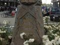
These demarcation stones are memorial stones that approximately indicate the extent of the German Western Front during World War I. They are 1.25 meters high, pink granite block stones. At the top, a soldier's helmet is displayed resting on a laurel wreath, on which the name of the front sector is inscribed. On the four corners, there is an image of a grenade, on the left side a canteen, and on the right side a gas mask.
In Belgium, there are three variants. The Belgian type has a Belgian Adrian helmet with a lion's head, the French type has a French Adrian helmet with the inscription RF, and the British type has a British Brodie helmet.
If the inscriptions have been preserved, one can read the following text (in 3 languages):
"Here the conqueror was brought to a standstill - Ici fut arrêté l'envahisseur - Here the invader was brought to a standstill".
The route starts in Nieuwpoort and ends in Loker, very close to the French border. Thus, you travel approximately along the front of World War I.
Has vist alguna cosa en aquesta ruta?Afegir un problema
Navega per la ruta a...
![]() Aplicació RouteYou Obriu
Aplicació RouteYou Obriu
Deixar de veure aquest anunci?
→ Millorar ara
![]()
Espereu, s'està preparant la navegació.
Ara pots navegar. Diverteix-te a la carretera!
Processament de la sol·licitud ha fracassat. Si us plau, torneu a intentar.
Deixar de veure aquest anunci?
→ Millorar ara
![]()
Espereu, s'està preparant la teva descàrrega.
La teva descàrrega està llesta. Diverteix-te a la carretera!
Processament de la sol·licitud ha fracassat. Si us plau, torneu a intentar.
Deixar de veure aquest anunci?
→ Millorar ara
![]()
Espereu, s'està preparant la teva impressió.
La teva impressió està llesta per descarregar. Diverteix-te a la carretera!
Processament de la sol·licitud ha fracassat. Si us plau, torneu a intentar.
<iframe src="https://plugin.routeyou.com/routeviewer/free/?language=ca&params.route.id=1022241&params.language=en" width="100%" height="600" frameborder="0" allowfullscreen></iframe>
<p><a class="routeYou_embed" href="https://app.routeyou.com/en-be/route/view/1022241?utm_source=embed&utm_medium=article&utm_campaign=routeshare&navigation=external" title="The19BoundaryMarkersLarge - RouteYou" target="_blank"><img src="https://image.routeyou.com/embed/route/960x670/1022241-en@2x.png" style="width: 100%; height: auto;" alt="The19BoundaryMarkersLarge"></a></p>
Feedback adicional:
Aquesta funció està disponible únicament per als subscriptors de RouteYou PREMIUM.
Prova-ho gratuïtament durant 1 mes i descobreix la diferència. No demanem dades de pagament i es desactiva automàticament després del període de prova d'un mes.
© 2006-2025 RouteYou - www.routeyou.com