1842 visites | Pública | Alemany • Francès • Italià • Neerlandès
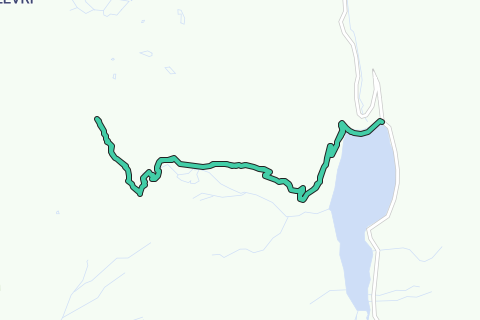
Route:
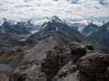
Today's summit: Le Sasseneire. With a height of 3253m one of the higher climbable mountains for the average hiker. Most trails end up on 3000m so this makes it a littlest more special.
The start of the route lies at the dam of Moiry with the artificial Lake "Lac de Moiry". You'll be amazed by the very bright blue color of the lake making it one of the nicest lakes in Switzerland.
To get to the summit you'll have to follow the directions to "Col de Torrent" above "Lac des Autannes". The col is situated at the border of Val d'Hérens. The paths start easy until you get to the farm and then a narrow path rises up with a good climb to the col. The view at the col is really amazing but is nothing compared to the view from the summit of le Sasseneire.
From Col de Torrent it's still pretty far to the summit of the Sasseneire, also called the Black Rock. Although in distance it may not be that far but due to the altitude and unmarked territory it makes it a bit more challenging.
From the col, no markings are visible, you'll have to search your way up to the summit along almost invisible 'paths' with loos rocks and sometimes a steep climb. When climbing the steeper part you'll quickly notice that there is less oxygen on this altitude.
The summit itself, where the cross stands, is the toughest part with a rock passage of 3m (Escalade facile I). If you don't want to cross that section, it's no problem because the summit is close and the view is as spectacular as it is there on the summit itself.
The view from the summit is truly amazing with views on the high +4000m mountains (Cervin, Ober Gabelhorn, Weishorn, ...) and the Mont Blanc mountain chain, the two valleys Val d'Hérens and Val d'Anniviers. You can sit here and look for hours around enjoying this spectacular view.
The return to the Moiry dam is the same path, back to the Col de Torrent and Lac de Moiry.
Tips:
- Only do this one with good weather conditions and no snow on or above 3000m. The danger of falling would be too high.
- At the summit, tougher part, be careful!
Has vist alguna cosa en aquesta ruta?Afegir un problema
Navega per la ruta a...
![]() Aplicació RouteYou Obriu
Aplicació RouteYou Obriu
Deixar de veure aquest anunci?
→ Millorar ara
![]()
Espereu, s'està preparant la navegació.
Ara pots navegar. Diverteix-te a la carretera!
Processament de la sol·licitud ha fracassat. Si us plau, torneu a intentar.
Deixar de veure aquest anunci?
→ Millorar ara
![]()
Espereu, s'està preparant la teva descàrrega.
La teva descàrrega està llesta. Diverteix-te a la carretera!
Processament de la sol·licitud ha fracassat. Si us plau, torneu a intentar.
Deixar de veure aquest anunci?
→ Millorar ara
![]()
Espereu, s'està preparant la teva impressió.
La teva impressió està llesta per descarregar. Diverteix-te a la carretera!
Processament de la sol·licitud ha fracassat. Si us plau, torneu a intentar.
<iframe src="https://plugin.routeyou.com/routeviewer/free/?language=ca&params.route.id=2259909&params.language=en" width="100%" height="600" frameborder="0" allowfullscreen></iframe>
<p><a class="routeYou_embed" href="https://app.routeyou.com/en-ch/route/view/2259909?utm_source=embed&utm_medium=article&utm_campaign=routeshare&navigation=external" title="To the summit of Le Sasseneire (3253m) - RouteYou" target="_blank"><img src="https://image.routeyou.com/embed/route/960x670/2259909-en@2x.png" style="width: 100%; height: auto;" alt="To the summit of Le Sasseneire (3253m)"></a></p>
Feedback adicional:
Aquesta funció està disponible únicament per als subscriptors de RouteYou PREMIUM.
Prova-ho gratuïtament durant 1 mes i descobreix la diferència. No demanem dades de pagament i es desactiva automàticament després del període de prova d'un mes.
© 2006-2025 RouteYou - www.routeyou.com