
 Azure
AzureSenne-Sennegat-Senne.
Departure and arrival of this 26km long flat bike/looplus along all straightened parts of the Senne is at the parking Voetbalplein Weerde (Galgenberg).
Most of the route is paved, only around the fish pit in Weerde and below hombeek it is a dolomite towpath.
This loop starts in Weerde from where the Senne has been straightened over the centuries up to the Znegat. You will therefore no longer see any natural meandering (for that you have to take this loop: ). However, it remains fun to follow this long winding river on the east and west sides due to the remoteness of the natural environment.
Easy to do by bike (also with children) or on foot.
In the Zennegat there is a drinking place in the summer and on weekends, as well as on the first fish vjver you will encounter when you take the Zenneat over the new bicycle bridge on the left bank. OOk in the intermediate municipalities of Heffen, Leest and Hombeek (each time on the liner bank - there is always a bridge that you can cross - there is a drinking facility. Once you have café de Rut between the tracks at the Weerde station where you can relax for a while.
At 1 place it is important to pay attention: Until halfway the Eglegegem pond (lying on the left bank, you have to leave the Senne on the right bank and take a bypass on the passing E19 (2x under crossing: keep on!). If you leave the Senne, the course is a 100m rather muddy, and can contain large puddles in heavy weather (where you can still cycle.)
At the Zennegat we first turn right at the bicycle bridge to pass the lock complex of the Zenne-Mechelen-Leuven canal on the left side. This gives you the opportunity to admire the Zennegar at the end (mouth Zenne in Dijle, with the Leuvensevaart in between.
Very easy and easy trip.
Har du lagt mærke til noget på denne rute?Tilføj et problem
Naviger ruten med...
 RouteYou app Åbn
Vil du ikke se denne annonce mere?
→ Opgrader nu

Et øjeblik, navigationen forberedes.
Du kan nu navigere. God fornøjelse på vejen!
Behandlingen af anmodningen mislykkedes. Prøv venligst igen.
Vil du ikke se denne annonce mere?
→ Opgrader nu
Et øjeblik, din download forberedes.
Din download er klar. God fornøjelse på farten!
Behandlingen af anmodningen mislykkedes. Prøv venligst igen.
Vil du ikke se denne annonce mere?
→ Opgrader nu
Et øjeblik, din udskrift forberedes.
Din udskrift er klar til download. God fornøjelse på farten!
Behandlingen af anmodningen mislykkedes. Prøv venligst igen.
<iframe src="https://plugin.routeyou.com/routeviewer/free/?language=da&params.route.id=2762569&params.language=en" width="100%" height="600" frameborder="0" allowfullscreen></iframe>
<p><a class="routeYou_embed" href="https://app.routeyou.com/en-be/route/view/2762569?utm_source=embed&utm_medium=article&utm_campaign=routeshare&navigation=external" title="Senne-Sennegat-Senne (26km) - RouteYou" target="_blank"><img src="https://image.routeyou.com/embed/route/960x670/2762569-en@2x.png" style="width: 100%; height: auto;" alt="Senne-Sennegat-Senne (26km)"></a></p>
Yderligere feedback:
Du skal mindst have en RouteYou PREMIUM-konto for at kunne bruge denne funktion.
Prøv nu 1 måned gratis og oplev forskellen! Vi beder ikke om betalingsoplysninger, og det stopper automatisk efter din prøveperiode på en måned.
© 2006-2026 RouteYou - www.routeyou.com



 wy
wy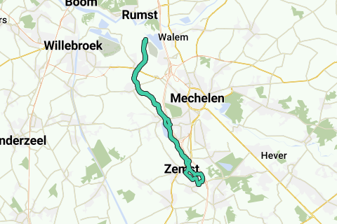





 Start
Start Download
 Download

