Takket være vores partner haroldslegers får du gratis adgang til denne rute – OG du kan lære RouteYou PLUS at kende.
Opdag alle fordelene9041 gange set | Offentlig | Fransk • Nederlandsk • Tysk
 Azure
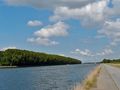
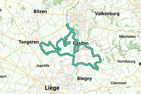
AzureStarting place is the church of Mariadorp. Via Eijsden you cycle to Belgium and follow the concrete cycle path / quay along the Albert Canal for miles.
You leave the Meuse valley via the ascent of the Montagne St.Pierre. The descent takes you into the valley of the Jeker, but first you cycle to Kanne to climb the Muizenberg and return to the valley of the Jeker via a paved towpath along the beautiful deepened Albert Canal.
Along the valley of the Jeker (in French this river is called Geer), there are beautiful slopes. The language border is crossed several times. Characteristic of the region north of the Jeker (Haspengouw) are the many good concrete roads leading through fields (for the benefit of farmers). The wind has free rein here. The busier roads in the Jekerdal are avoided by following free-lying cycle paths (including a paved cycle path over a former railway line), and by following roads where only agricultural traffic is allowed.
Around the Jekerdal you get the following climbs:
- Plattenberg (also known as Tiendeberg or Zusserdel), beautiful climb over ever-winding road through the orchards.
- Côte de Wonck.
- Sur Les Coteaux (average 4%, maximum 6% and 1.8 kilometers long).
- Thier Saint Laurent
- Chavée Arecht / Arechtberg (max. 15%).
Then you descend the western side of the Hallembaye on a narrow asphalted back road, but be careful: there is a fence at the bottom of the descent. Via the cycle path along the western side of the Albert Canal you arrive in Hermalle-sous-Argenteau and cross the Meuse. You climb out of the Meuse valley via Rue de Richelle. The descent that follows takes you to Dalhem and the Voer region where the river Berwijn (in French Berwinne) has carved out a considerable relief. The two climbs in the Voer region (Clos du Grand Sart and the climb to Neufchateau) also have the largest height difference on this track. Also enjoy the beautiful views after passing the village of Neufchateau! A long descent takes you to Warsage and then soon back to the Dutch-speaking area.
Har du lagt mærke til noget på denne rute?Tilføj et problem
Naviger ruten med...
![]() RouteYou app Åbn
RouteYou app Åbn
![]()
Et øjeblik, din udskrift forberedes.
Din udskrift er klar til download. God fornøjelse på farten!
Behandlingen af anmodningen mislykkedes. Prøv venligst igen.
<iframe src="https://plugin.routeyou.com/routeviewer/free/?language=da&params.route.id=4571909&params.language=en" width="100%" height="600" frameborder="0" allowfullscreen></iframe>
<p><a class="routeYou_embed" href="https://app.routeyou.com/en-nl/route/view/4571909?utm_source=embed&utm_medium=article&utm_campaign=routeshare&navigation=external" title="Variant slopes along the Jekerdal, Maasdal and Berwijndal - RouteYou" target="_blank"><img src="https://image.routeyou.com/embed/route/960x670/4571909-en@2x.png" style="width: 100%; height: auto;" alt="Variant slopes along the Jekerdal, Maasdal and Berwijndal"></a></p>
Yderligere feedback:
Du skal mindst have en RouteYou PREMIUM-konto for at kunne bruge denne funktion.
Prøv nu 1 måned gratis og oplev forskellen! Vi beder ikke om betalingsoplysninger, og det stopper automatisk efter din prøveperiode på en måned.
© 2006-2025 RouteYou - www.routeyou.com