Dank unseres Partners Pasar vzw erhältst Du kostenlosen Zugang zu dieser Route - UND Du lernst RouteYou PLUS kennen.
Entdecke alle Vorteile2998 Aufrufe | Öffentlich | Deutsch • Französisch • Niederländisch
1. Appointment at the Market (V) of Sint-Katelijne-Waver. Between the new Sint-Catharinakirk (built in 1994) and the old town hall with its massive central tower, there are plenty of parking spaces available. Go from the market into Wilsonstraat, towards Hondsbossen, and after 200 m turn right into Bosbeekweg. After 200 m at the T-junction, take the gravel path on the left (orange-red square sign). The gravel path becomes a field path and bends slightly to the right. Continue 50 m to the left at the fork. A bit further on, cross the paved path and continue along the ditch (orange-red square sign).
2. You will soon find yourself at an information board for Hondsbossen? The Hondsbossen are a remnant of the early medieval Waver forest that stretched between Nete and Dijle and is managed by Natuurpunt. The unpaved hiking trails can be very muddy in winter or after a few days of rain. Good boots are then not a luxury. Stay along the Kammaarbeeks and at the edge of the forest. In spring, many large walls and very fragrant lily of the valleys bloom here. Where the forest path bends at right angles to the right, after a few meters you turn left onto a path at the edge of the meadow. Go left on the wide country road. Along and at the stream, you will find wild ducks and moorhens. After 250 m, you reach an asphalt road. Go right. After just over a kilometer, the asphalt path narrows to a bike path and later bends at right angles to the left and then to the right. There is a bench on the left, and the asphalt path widens again. Continue 100 m to the left onto a wide gravel path and at house number 19 turn right. The gravel path bends left and leads you back to an asphalt road. Go left and after 250 m turn right (sign Tuindersroute) along one of the many large greenhouses here in the landscape. At the T-junction, turn left onto a single-lane concrete path and after 300 m turn right into Donderheide number 13 (also signs with green and red arrows). The concrete path becomes a forest path. Go straight ahead. Where the forest path bends to the right (pay close attention, as you will quickly pass it!), you go diagonally left onto a wide field path between the open fields. At the end of the field path, go straight ahead down a steep narrow path. After a few meters, you will stand by a wide unpaved road next to the water around the Fort of Koningshooikt?
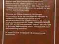
3. Go right and enjoy the beautiful view of the water, the greenery, and the many fishing spots. Over most of the fishing spots, a hut or garden house or (even furnished) holiday home has been built. Unfortunately, there are also some very dilapidated ones among them. Continue around the water, and after two curves, you will walk along a concrete path and reach the entrance of the fort. The Fort of Koningshooikt dates back to 1859 and is part of the Antwerp position. At the beginning of World War I, there was indeed fighting around it, but during World War II, it served as a storage facility for the German army during the occupation. Today, among other things, it serves as a wintering reserve for, according to the latest counts, eight species of bats. Now continue along the concrete path and after about 600 m at the T-junction, turn right. The concrete path bends at right angles to the left and then to the right. After another 2 curves, you find yourself in Waterstraat. Turn left and after 800 m further, at Muilshoek, turn right. Carefully cross the country road and go straight on a wide gravel path for another half kilometer through a particularly quiet and green environment.
Turn left on the asphalt road and again turn left on the big road. The fairly busy road forms a stark contrast, but after barely a kilometer you find yourself back at the market of Sint-Katelijne-Waver and can enjoy a fresh beer at one of the terraces.
Ist Ihnen auf dieser Route etwas aufgefallen?Problem hinzufügen
Route navigieren in...
![]() RouteYou-App Öffnen
RouteYou-App Öffnen
![]()
Bitte warten Sie, Ihr Ausdruck wird vorbereitet.
Ihr Ausdruck ist bereit für den Download. Viel Routen-Spaß!
Bearbeitung Ihrer Anfrage ist fehlgeschlagen. Bitte versuchen Sie es erneut.
<iframe src="https://plugin.routeyou.com/routeviewer/free/?language=de&params.route.id=5295245&params.language=en" width="100%" height="600" frameborder="0" allowfullscreen></iframe>
<p><a class="routeYou_embed" href="https://app.routeyou.com/en-be/route/view/5295245?utm_source=embed&utm_medium=article&utm_campaign=routeshare&navigation=external" title="Hondsbossen and a fortress - RouteYou" target="_blank"><img src="https://image.routeyou.com/embed/route/960x670/5295245-en@2x.png" style="width: 100%; height: auto;" alt="Hondsbossen and a fortress"></a></p>
Zusätzliches Feedback:
Diese Funktion ist ausschließlich für RouteYou PREMIUM-Abonnenten verfügbar.
Testen Sie 1 Monat kostenlos und entdecken Sie den Unterschied! Wir erfassen keine Zahlungsdaten und Ihre Testversion endet automatisch nach einem Monat.
© 2006-2026 RouteYou - www.routeyou.com