Esta caminata de montaña de dificultad ligera a moderada comienza en Galtür y conduce a una fascinante región de alta montaña. A lo largo del camino por el romántico Jamtal, se abren maravillosas vistas de las cumbres de Silvretta, especialmente del glaciar Jamtal con las cimas Jamtalspitzen (3.156 y 3.178 metros) y la cumbre de los Tres Países (3.197 metros). El objetivo de la excursión es el refugio Jamtal, gestionado, a 2.165 metros de altura. Después de una pausa, se regresa por el mismo camino.
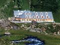
Desde la parada de autobús junto a la iglesia de Galtür (1.584 metros), se dirige hacia el sur, adentrándose en el Jamtal y siguiendo el río Jambach con una pendiente moderada en dirección valle arriba. Se sigue el "sendero hacia el refugio Jamtal". La primera parada intermedia es la Schnapfenalpe (1.735 metros), que se alcanza tras aproximadamente una hora de caminata. Aquí pastan vacas de Göfis, en Vorarlberg, y del valle de Innsbruck en Tirol. Desde el otro lado, se saluda la Scheibenalpe. Ahora el terreno cambia, los pastizales son reemplazados por un desagüe rocoso. Pasarelas de madera ayudan a cruzar dos ríos, el sendero se serpentea hasta la base del glaciar Jamtal y al refugio Jamtal (2.165 metros). Aquí vale la pena hacer un recorrido detrás de la casa para disfrutar de la vista del final del valle con las cimas del macizo Augstenberg y los cercanos campos glaciares. Los montañeros utilizan el refugio como base para excursiones extensas. Decenas de cumbres pueden ser alcanzadas desde aquí.
See something wrong on this route?Add an issue
Navigate route in...
![]() RouteYou app Open
RouteYou app Open
Don't want to see this ad anymore?
→ Upgrade now
![]()
Please wait, the navigation is being prepared.
You can now navigate. Have fun on the road!
Processing your request has failed. Please try again.
Don't want to see this ad anymore?
→ Upgrade now
![]()
Please wait, your download is being prepared.
Your download is ready. Have fun on the road!
Processing your request has failed. Please try again.
Don't want to see this ad anymore?
→ Upgrade now
![]()
Please wait, your print is being prepared.
Your print is ready to download. Have fun on the road!
Processing your request has failed. Please try again.
<iframe src="https://plugin.routeyou.com/routeviewer/free/?language=en&params.route.id=15259288&params.language=es" width="100%" height="600" frameborder="0" allowfullscreen></iframe>
<p><a class="routeYou_embed" href="https://app.routeyou.com/es-at/route/view/15259288?utm_source=embed&utm_medium=article&utm_campaign=routeshare&navigation=external" title="Jamtalhütte - RouteYou" target="_blank"><img src="https://image.routeyou.com/embed/route/960x670/15259288-es@2x.png" style="width: 100%; height: auto;" alt="Jamtalhütte"></a></p>
Additional feedback:
This feature is only available to RouteYou PREMIUM subscribers.
Try 1 month for free and discover the difference! We don't take any payment details, and your trial ends automatically after one month.
© 2006-2026 RouteYou - www.routeyou.com