Grâce à notre partenaire haroldslegers, vous pouvez accéder gratuitement à cet itinéraire - et découvrir RouteYou PLUS.
Découvrez tous les avantages5006 vues | Public | allemand • français • néerlandais
 Azure
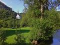
AzureThe Ahreifel is beautiful: climbs up to 6 km in length, many with hairpin bends, good and often quiet roads, mostly views on the crests (and no dense forest). The busy main road in the Ahr valley is bypassed in this valley by the well-paved exposed cycle path.
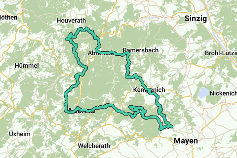
The route starts in Kreuzberg (some possibilities: hiking car park just before the bridge over the Ahr, or the car park on Bahnhofstraße). The route follows in a clockwise direction. First it goes a few kilometers on the bike path along the Ahr. Then it goes from the Ahr valley (at an altitude of 180 meters) to an altitude of about 600 meters. Then it goes over 2 climbs (which are steeper than on the rest of the route, up to 14%) to the beautiful Bürresheimer Castle. Then the path climbs from the village of Nitztal to Waldesch: this is a really nice climb over a narrow lonely road. Then it sets course for Langenfeld, then descends and, after 4 hairpin bends, turns left directly back up to the summit of the Raßberg: This area is known for its juniper bushes and the road is partially closed to car traffic. The route passes the highest point of the Eifel (the Hohe Acht) and leads down to Adenau. Adenau is a bustling village on the Nürburgring. Then it goes uphill again to Reifferscheid and over a quiet road hidden between the trees, in the direction of the Ahr valley. What remains are two beautiful climbs and equally beautiful descents (with many hairpin bends) around the valley of the Sahrbach.
Vous avez remarqué quelque chose sur cet itinéraire ?Ajouter rapport
Parcourir l'itinéraire dans...
![]() Application RouteYou Ouvrez
Application RouteYou Ouvrez
![]()
Veuillez patienter, votre impression est en cours de préparation.
Votre impression est prête à être téléchargée. Bonne route !
Le traitement de la demande a échoué. Veuillez réessayer.
<iframe src="https://plugin.routeyou.com/routeviewer/free/?language=fr&params.route.id=4419564&params.language=en" width="100%" height="600" frameborder="0" allowfullscreen></iframe>
<p><a class="routeYou_embed" href="https://app.routeyou.com/en-de/route/view/4419564?utm_source=embed&utm_medium=article&utm_campaign=routeshare&navigation=external" title="Hohe Eifel & Ahreifel - RouteYou" target="_blank"><img src="https://image.routeyou.com/embed/route/960x670/4419564-en@2x.png" style="width: 100%; height: auto;" alt="Hohe Eifel & Ahreifel"></a></p>
Commentaires supplémentaires :
Cette fonctionnalité est exclusivement disponible pour les abonnés RouteYou PREMIUM.
Essayez 1 mois gratuit maintenant et découvrez la différence ! Nous n'exigeons aucune donnée de paiement et le service s'arrête automatiquement après votre période d'essai d'un mois.
© 2006-2026 RouteYou - www.routeyou.com