277 vues | Public | Italien • allemand • français • néerlandais
Overview:
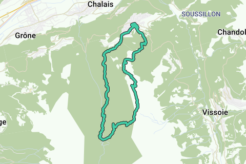
The starting point of the hike is at the ski station of Vercorin, this is a free parking area. From here you get two options, you can take the lift to Crêt du Midi or you'll hike to it. In this guide we'll do it on foot.
From the path to Crêt du Midi you'll get some nice views over Vercorin and the rest of the valley of Val d'Anniviers. The paths are big and once you'll get a bit higher it will get steeper on the ski slopes. But after a few hours of climbing you'll finally see the Crêt du Midi.
The Crêt du midi lies at a height of 2300m and on the border of Val d'Anniviers with Val de Réchy. You can already catch a glimpse of this valley from here. We do not enter the valley yet, first we have a mountain to conquer.
We set foot to La Brinta and Col de La Brinta, yet another 360m of climbing ahead. Along the path we cross Mont Major, a smaller mountain, before climbing on the hillside of La Brinta. The summit of La Brinta can not be climbed, unless with some extra materials, so the path lies just beneath it. From here it gets a bit more dangerous so be careful at this point. As you can see in the guide pictures some steep paths with chains and some smaller paths along the ridge awaits you. This part can be relatively easily crossed. Hereafter we finally reach Col de la Brinta, our gate to the Val de Réchy.
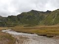
From the col you'll get an amazing view over the untamed valley and it's surrounding mountains. From the col we enter the valley in the direction of Le Pichioc. During this descent you'll keep getting an amazing view. Once you reached Le Pichioc, where also the small river La Réche tumbles down the valley, the view on L'Ar du Tsan is amazing.
Time to descent further down the valley along the waterfall of La Réche. The path is narrow and a bit steeper but do look back to the waterfall. It's really amazing.
Once you crossed La Réche it's time to dive into the forest before we reach a little cabane at the start of Chemin des Bisses. This last piece of the hike runs along the Bisse de Vercorin, a small irrigation way that provided water to Vercorin and to run the watermills. The irrigation way has been restored and is still functional. You'll keep following the bisse until you are back in Vercorin where the hike started.
Hiking classification: T3 – Challenging Mountain Hikes (between La Brinta and Col de la Brinta), all other paths T2 - Mountain hikes.
Vertical ascent: 1380m
Vertical descent: 1370m
Story:
This time we would do a visit to the pure valley of Val de Réchy, starting point was Vercorin. As always we don't take chairlifts and skilifts so we go on foot to the Crêt du Midi.
At first, the path to Crêt du Midi was along the ski slopes but once a bit higher on the mountain we get on some smaller paths and "Chemin des Marmottes", a path for the younger ones with some games. So this piece of trail is good to do with your family but the second part isn't.
Once the Crêt du Midi is reached at 2300m we'll go on an exciting route to La Brinta before we enter the valley of Val de Réchy. First piece of path to La Brinta is relatively easy. The first climb is to Mont Major, the second La Brinta. Just beneath La Brinta there was a part with chains and some steeper climbs and narrow paths along the ridge. I loved this path really ;-).
Now we conquered the Brinta it was time to explore the pure valley of Val de Réchy. From Col de la Brinta the view was already great, once down at Le Piehioc the sight was also really beautiful. The waterfall of La Réche is really neat, from the path down you'll get some better views on it too.
The last part of the hike is along the Bisse de Vercorin, a small irrigation way that leads to Vercorin and was restored so it works like it was used too in the 1800-1900.
Great hike with great views.
Vous avez remarqué quelque chose sur cet itinéraire ?Ajouter rapport
Parcourir l'itinéraire dans...
![]() Application RouteYou Ouvrez
Application RouteYou Ouvrez
Vous ne voulez plus voir cette publicité ?
→ Actualiser maintenant
![]()
Veuillez patienter, la navigation est en cours de préparation.
Vous pouvez maintenant naviguer. Bonne route !
Le traitement de la demande a échoué. Veuillez réessayer.
Vous ne voulez plus voir cette publicité ?
→ Actualiser maintenant
![]()
Veuillez patienter, votre téléchargement est en cours de préparation.
Votre téléchargement est prêt. Bonne route !
Le traitement de la demande a échoué. Veuillez réessayer.
Vous ne voulez plus voir cette publicité ?
→ Actualiser maintenant
![]()
Veuillez patienter, votre impression est en cours de préparation.
Votre impression est prête à être téléchargée. Bonne route !
Le traitement de la demande a échoué. Veuillez réessayer.
<iframe src="https://plugin.routeyou.com/routeviewer/free/?language=fr&params.route.id=2260114&params.language=en" width="100%" height="600" frameborder="0" allowfullscreen></iframe>
<p><a class="routeYou_embed" href="https://app.routeyou.com/en-ch/route/view/2260114?utm_source=embed&utm_medium=article&utm_campaign=routeshare&navigation=external" title="Exploring Val de Réchy from Vercorin - RouteYou" target="_blank"><img src="https://image.routeyou.com/embed/route/960x670/2260114-en@2x.png" style="width: 100%; height: auto;" alt="Exploring Val de Réchy from Vercorin"></a></p>
Commentaires supplémentaires :
Cette fonctionnalité est exclusivement disponible pour les abonnés RouteYou PREMIUM.
Essayez 1 mois gratuit maintenant et découvrez la différence ! Nous n'exigeons aucune donnée de paiement et le service s'arrête automatiquement après votre période d'essai d'un mois.
© 2006-2025 RouteYou - www.routeyou.com