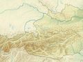
This mountain hike of intermediate difficulty takes in the 2,560m Hochzeiger peak. It begins with a walk into the Riegetal Valley, a side valley branching off the larger Pitztal Valley. This quiet and secluded region in the west of Tirol is a protected nature reserve and home to a rich variety of flora and fauna. Highlights include marmots, mountain salamanders, chamoix and sheep as well as many alpine flowers in bloom. The hike also passes the Groaßsee lake, one of the most beautiful mountain lakes in the Pitztal Valley, where the craggy peaks of the Wildgrat mountains are reflected on the water's surface.
This circular hike into the Riegetal Valley, a protected nature reserve, begins at the mid-way station of the Hochzeiger cable car. From there, hikers follow trail no. 12 towards Zollberg. From Zollberg the route continues along a narrow path, the "Goaßsteig", with several sections secured with ropes, down into the Riegetal Valley. Then the trail becomes easier and leads through the idyllic valley to the Großsee lake. After a rest next to the lake, the route leads back along the same route before branching off right onto a steeper trail leading towards the Hochzeiger mountain. At the peak of the Hochzeiger at 2,560 metres above sea level there is time to admire the view and write your name into the log book stored at the mighty cross atop the summit before descending along the easily visible trail leading down to the mid-way station of the Hochzeiger cable car.
Risorsa: Visit Tirol
Hai notato qualcosa su questo itinerario?Aggiungere un problema
Naviga nel percorso in...
![]() App RouteYou Aprire
App RouteYou Aprire
Vuoi smettere di vedere questo annuncio?
→ Upgrade ora
![]()
Attendi, la navigazione è in preparazione.
Ora puoi navigare. Buon divertimento in viaggio!
Elaborazione della richiesta non è riuscita. Si prega di riprovare.
Vuoi smettere di vedere questo annuncio?
→ Upgrade ora
![]()
Attendi, il tuo download è in preparazione.
Il tuo download è pronto. Buon divertimento in viaggio!
Elaborazione della richiesta non è riuscita. Si prega di riprovare.
Vuoi smettere di vedere questo annuncio?
→ Upgrade ora
![]()
Attendi, la tua stampa è in preparazione.
La tua stampa è pronta per il download. Buon divertimento in viaggio!
Elaborazione della richiesta non è riuscita. Si prega di riprovare.
<iframe src="https://plugin.routeyou.com/routeviewer/free/?language=it&params.route.id=15262295&params.language=en" width="100%" height="600" frameborder="0" allowfullscreen></iframe>
<p><a class="routeYou_embed" href="https://app.routeyou.com/en-at/route/view/15262295?utm_source=embed&utm_medium=article&utm_campaign=routeshare&navigation=external" title="Riegetal – Großsee – Hochzeiger - RouteYou" target="_blank"><img src="https://image.routeyou.com/embed/route/960x670/15262295-en@2x.png" style="width: 100%; height: auto;" alt="Riegetal – Großsee – Hochzeiger"></a></p>
Altri commenti:
Questa funzionalità è disponibile esclusivamente per gli abbonati a RouteYou PREMIUM.
Prova 1 mese gratis e scopri la differenza! Non prendiamo alcun dettaglio di pagamento e la tua prova termina automaticamente dopo un mese.
© 2006-2026 RouteYou - www.routeyou.com