This route takes you into one of the largest forests in East Flanders, south of Maldegem. The tour starts at the edge of Drongengoed and Maldegemveld and then proceeds through the most beautiful parts of Maldegemveld and Drongengoed.
The starting point is a parking lot along the Krakeelweg, where there is always plenty of space available. You can also always park your vehicle at Jagershof.
For this route, an effort has been made to use as little asphalt or concrete roads as possible, which is not always easy, but this route runs over more than 80% on paved paths, alleys, and forest trails. Most paths are clearly visible, while the section to return to Drongengoed via Schapersbosstraat is initially a clear path that turns into a semi-overgrown trail after the left turn, where navigation requires a bit more attention. Once we are back on the road, we also take a small passage through the forest that is less visible.
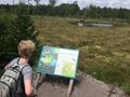
Along the route, you will learn more about Maldegemveld at various points, the heathland rewilding undertaken by Natuurpunt, as well as water management to mitigate flooding. In addition to the educational aspect of the tour, you can enjoy the beauty of the forest as well as the meadows and alleys that characterize the area.
There is also an official bivouac site in Kleit along the route, which includes a barbecue area and is an ideal resting place.
Hai notato qualcosa su questo itinerario?Aggiungere un problema
Naviga nel percorso in...
![]() App RouteYou Aprire
App RouteYou Aprire
Vuoi smettere di vedere questo annuncio?
→ Upgrade ora
![]()
Attendi, la navigazione è in preparazione.
Ora puoi navigare. Buon divertimento in viaggio!
Elaborazione della richiesta non è riuscita. Si prega di riprovare.
Vuoi smettere di vedere questo annuncio?
→ Upgrade ora
![]()
Attendi, il tuo download è in preparazione.
Il tuo download è pronto. Buon divertimento in viaggio!
Elaborazione della richiesta non è riuscita. Si prega di riprovare.
Vuoi smettere di vedere questo annuncio?
→ Upgrade ora
![]()
Attendi, la tua stampa è in preparazione.
La tua stampa è pronta per il download. Buon divertimento in viaggio!
Elaborazione della richiesta non è riuscita. Si prega di riprovare.
<iframe src="https://plugin.routeyou.com/routeviewer/free/?language=it&params.route.id=3716816&params.language=en" width="100%" height="600" frameborder="0" allowfullscreen></iframe>
<p><a class="routeYou_embed" href="https://app.routeyou.com/en-be/route/view/3716816?utm_source=embed&utm_medium=article&utm_campaign=routeshare&navigation=external" title="Through the forest and heath of the Maldegem field and Drongengoed - RouteYou" target="_blank"><img src="https://image.routeyou.com/embed/route/960x670/3716816-en@2x.png" style="width: 100%; height: auto;" alt="Through the forest and heath of the Maldegem field and Drongengoed"></a></p>
Altri commenti:
Questa funzionalità è disponibile esclusivamente per gli abbonati a RouteYou PREMIUM.
Prova 1 mese gratis e scopri la differenza! Non prendiamo alcun dettaglio di pagamento e la tua prova termina automaticamente dopo un mese.
© 2006-2025 RouteYou - www.routeyou.com