Link copiato. Incolli il link su Instagram per condividere l'itinerario.

 Azure
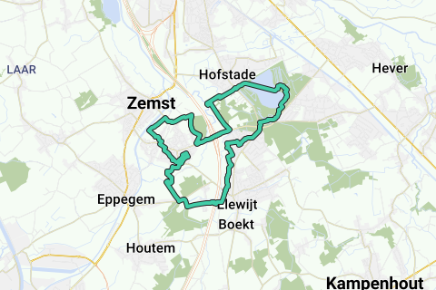
Round the weather along historic sites and roads over a loop length of 10Miles (16.09km).
This green loop departs from Ons Huis (HQ KWB Weerde on the Kostervoetweg, 100m from the Church of Weerde and café 't Schoonzicht (ample parking space at the church) which takes you in a counter-hour direction along Elewijt and the Blosodomein Hofstade. Of course you can start at any other point on the loop.
The loop is drawn along mainly historical roads and sights (enlarge the map and click on the POIs in the map for additional explanation): including the remains of Weerdemolen on the best preserved Zennemeanders above Brussels (watermill destroyed in WWI, only the toll house remains); the Rubens Castle and the Steenmolen along the Barebeekmeander (closed by the E19); Diependael Castle (currently a privately owned restaurant); the Bloso domain with the boat restaurant, the war memorial and the listed bathhouse; the last remaining pedestrian bridge that served as a slow road over the Senne between Hofstade and Weerde; the large Hofstade and Weerde ponds that were created by sand extraction for the Weerde-Muizen-Mechelen rail connection and the E19.
In Elewijt, the part between the Barebeek and the Tervuursesteenweg is cut (Waversebaan and Heirbaan), where almost 2000 years ago the Roman stone road ran between Tienen and Asse (on the Tongeren-Bonen connection, see http://www.dezemstenaar.com/ARCHIEF/zemstenaar%2052%20-%20april.pdf page 7, http://nl.wikipedia.org/wiki/Heirbaan_Tongeren-Bonen, http://nl.wikipedia.org/wiki/Via_Belgica, http://www.megalitica.be/halvestn/banen.htm), and where there are several remains of a Gallo-Roman settlement were found. In the period when the Senne regularly flooded the entire area of Weerde (a 'weerde' is a sandy elevation in swamp or flood area along a watercourse), there was already a Gallo-Roman activity in this part of Elewijt on this right bank of the Barebeek (just east of the Senne basin).
Also read the group information 'Weerde' for additional references and facts.
This loop is seasoned with various rural panoramas, field areas, trousers (Vriezenbroek between Blosodomein and E19, swamp zone along the Bossenhoek south of the Senne diversion), and several footpaths in Weerdse and in Elewijt.
In summary: A historically interesting, varied and quietly walkable 16.1km loop for hikers (including various options for a drink and a snack, see the POIs); a well-walkable and quiet 10miles loop for runners; A flat effe-to-rest-recreational rural cycling loop with or without the family.
The only weak point is the crossing from east to west on the E19 when returning: watch out for car traffic entering or leaving the E19!
Info to the people outside Zemst: In hot summer weather, the passage through the classified bathhouse in the Bloso domain (see POIs) is paid (safety considerations after hoopla with Brussels youngsters). If you start this loop in hot summer weather and want to skip this paying part, do not take the pedestrian bridge on the left over the large canal in the Bloso domain, but continue to follow this canal on your left until the end. You can then connect back behind the Sportimonium with the mapped loop.
Hai notato qualcosa su questo itinerario?Aggiungere un problema
Naviga nel percorso in...
 App RouteYou Aprire
Vuoi smettere di vedere questo annuncio?
→ Upgrade ora

Attendi, la navigazione è in preparazione.
Ora puoi navigare. Buon divertimento in viaggio!
Elaborazione della richiesta non è riuscita. Si prega di riprovare.
Vuoi smettere di vedere questo annuncio?
→ Upgrade ora
Attendi, il tuo download è in preparazione.
Il tuo download è pronto. Buon divertimento in viaggio!
Elaborazione della richiesta non è riuscita. Si prega di riprovare.
Vuoi smettere di vedere questo annuncio?
→ Upgrade ora
Attendi, la tua stampa è in preparazione.
La tua stampa è pronta per il download. Buon divertimento in viaggio!
Elaborazione della richiesta non è riuscita. Si prega di riprovare.
Altri commenti:
Questa funzionalità è disponibile esclusivamente per gli abbonati a RouteYou PREMIUM.
Prova 1 mese gratis e scopri la differenza! Non prendiamo alcun dettaglio di pagamento e la tua prova termina automaticamente dopo un mese.
© 2006-2026 RouteYou - www.routeyou.com



 wy



 Comincia
 Scarica
 Scarica


