Azure
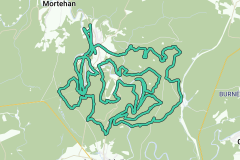
AzureLe Tombeau du Chevalier trail (58.76 km; D+ 2100m); southern version Herbeumont.
Based on http://www.festival-trail-semois.be/index.php's latest trail 'under construction' data, NGI topographic maps, own knowledge of the area and GPX records of the most important parts of the trail. The current trail eventually became not this one, but the north trail.
Following the Semois between Les Mauleûx and La Roche du Chat, I deviated from the path under construction and followed the forest path along the Semois to the south, after which the ascent begins north to Rue des Épioux along a forest road.
The flat distance is therefore 57km, the actual distance that takes into account the elevations to be covered is 58.76km; The altimeters to overcome are 2100m. See the first POI of this loop (Topographic Data The Knight's Tomb) for a detailed map and figures.
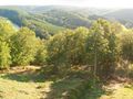
This trail is highly recommended for athletes who like to stay in the forest and who like an altitude difference of more than 2000m over more than 55km.
Hai notato qualcosa su questo itinerario?Aggiungere un problema
Naviga nel percorso in...
![]() App RouteYou Aprire
App RouteYou Aprire
Vuoi smettere di vedere questo annuncio?
→ Upgrade ora
![]()
Attendi, la navigazione è in preparazione.
Ora puoi navigare. Buon divertimento in viaggio!
Elaborazione della richiesta non è riuscita. Si prega di riprovare.
Vuoi smettere di vedere questo annuncio?
→ Upgrade ora
![]()
Attendi, il tuo download è in preparazione.
Il tuo download è pronto. Buon divertimento in viaggio!
Elaborazione della richiesta non è riuscita. Si prega di riprovare.
Vuoi smettere di vedere questo annuncio?
→ Upgrade ora
![]()
Attendi, la tua stampa è in preparazione.
La tua stampa è pronta per il download. Buon divertimento in viaggio!
Elaborazione della richiesta non è riuscita. Si prega di riprovare.
<iframe src="https://plugin.routeyou.com/routeviewer/free/?language=it&params.route.id=709108&params.language=en" width="100%" height="600" frameborder="0" allowfullscreen></iframe>
<p><a class="routeYou_embed" href="https://app.routeyou.com/en-be/route/view/709108?utm_source=embed&utm_medium=article&utm_campaign=routeshare&navigation=external" title="Trail Le Tombeau du Chevalier (58.8km), South version Herbeumont - RouteYou" target="_blank"><img src="https://image.routeyou.com/embed/route/960x670/709108-en@2x.png" style="width: 100%; height: auto;" alt="Trail Le Tombeau du Chevalier (58.8km), South version Herbeumont"></a></p>
Altri commenti:
Questa funzionalità è disponibile esclusivamente per gli abbonati a RouteYou PREMIUM.
Prova 1 mese gratis e scopri la differenza! Non prendiamo alcun dettaglio di pagamento e la tua prova termina automaticamente dopo un mese.
© 2006-2025 RouteYou - www.routeyou.com