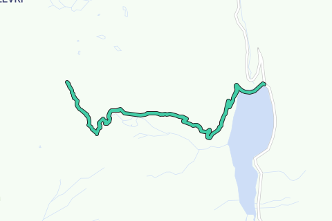
Route:
Today's summit: Le Sasseneire. With a height of 3253m one of the higher climbable mountains for the average hiker. Most trails end up on 3000m so this makes it a littlest more special.
The start of the route lies at the dam of Moiry with the artificial Lake "Lac de Moiry". You'll be amazed by the very bright blue color of the lake making it one of the nicest lakes in Switzerland.
To get to the summit you'll have to follow the directions to "Col de Torrent" above "Lac des Autannes". The col is situated at the border of Val d'Hérens. The paths start easy until you get to the farm and then a narrow path rises up with a good climb to the col. The view at the col is really amazing but is nothing compared to the view from the summit of le Sasseneire.
From Col de Torrent it's still pretty far to the summit of the Sasseneire, also called the Black Rock. Although in distance it may not be that far but due to the altitude and unmarked territory it makes it a bit more challenging.
From the col, no markings are visible, you'll have to search your way up to the summit along almost invisible 'paths' with loos rocks and sometimes a steep climb. When climbing the steeper part you'll quickly notice that there is less oxygen on this altitude.
The summit itself, where the cross stands, is the toughest part with a rock passage of 3m (Escalade facile I). If you don't want to cross that section, it's no problem because the summit is close and the view is as spectacular as it is there on the summit itself.
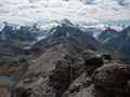
The view from the summit is truly amazing with views on the high +4000m mountains (Cervin, Ober Gabelhorn, Weishorn, ...) and the Mont Blanc mountain chain, the two valleys Val d'Hérens and Val d'Anniviers. You can sit here and look for hours around enjoying this spectacular view.
The return to the Moiry dam is the same path, back to the Col de Torrent and Lac de Moiry.
Tips:
- Only do this one with good weather conditions and no snow on or above 3000m. The danger of falling would be too high.
- At the summit, tougher part, be careful!
Hai notato qualcosa su questo itinerario?Aggiungere un problema
Naviga nel percorso in...
![]() App RouteYou Aprire
App RouteYou Aprire
Vuoi smettere di vedere questo annuncio?
→ Upgrade ora
![]()
Attendi, la navigazione è in preparazione.
Ora puoi navigare. Buon divertimento in viaggio!
Elaborazione della richiesta non è riuscita. Si prega di riprovare.
Vuoi smettere di vedere questo annuncio?
→ Upgrade ora
![]()
Attendi, il tuo download è in preparazione.
Il tuo download è pronto. Buon divertimento in viaggio!
Elaborazione della richiesta non è riuscita. Si prega di riprovare.
Vuoi smettere di vedere questo annuncio?
→ Upgrade ora
![]()
Attendi, la tua stampa è in preparazione.
La tua stampa è pronta per il download. Buon divertimento in viaggio!
Elaborazione della richiesta non è riuscita. Si prega di riprovare.
<iframe src="https://plugin.routeyou.com/routeviewer/free/?language=it&params.route.id=2259909&params.language=en" width="100%" height="600" frameborder="0" allowfullscreen></iframe>
<p><a class="routeYou_embed" href="https://app.routeyou.com/en-ch/route/view/2259909?utm_source=embed&utm_medium=article&utm_campaign=routeshare&navigation=external" title="To the summit of Le Sasseneire (3253m) - RouteYou" target="_blank"><img src="https://image.routeyou.com/embed/route/960x670/2259909-en@2x.png" style="width: 100%; height: auto;" alt="To the summit of Le Sasseneire (3253m)"></a></p>
Altri commenti:
Questa funzionalità è disponibile esclusivamente per gli abbonati a RouteYou PREMIUM.
Prova 1 mese gratis e scopri la differenza! Non prendiamo alcun dettaglio di pagamento e la tua prova termina automaticamente dopo un mese.
© 2006-2025 RouteYou - www.routeyou.com