Link copiato. Incolli il link su Instagram per condividere l'itinerario.

 Azure
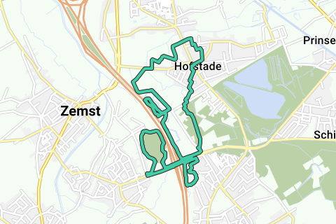
Walking/walking on paths in and between Weerde and Hofstade. Very varied walking loop for children (some scrambling, between (and over fallen) trees and along water); and with several pit stop options halfway in Hofstade.
Departure and arrival of the GPX is at Ground Zero Weerde (Weerdse Bierfeesten and Zomefeesten). You can of course start the loop at any other point, such as at the Church in Hofstade.
It is conceived as a trail in which the berm of the Schumanlaan is climbed and climbed (at the bicycle crossing under the Schumanlaan). You can avoid this by taking the 'easy' way a little further.
In order of the GPX, the following 'nature reserves' are completed:
-Schumanlaan roadside at bicycle crossing;
-loop Geuzenhoek on Barebeek left bank;
-(bicycle crossing Schumanlaan);
-Vriezenbroek on the Barebeek left bank;
-Barebeek crossing on footpath 27B under railway line 27B;
-(Central low-traffic passage through Hofstade center);
-old Gasthuishofstraat, Gasthuishofbos, Oude Zemstsesteenweg with Barebeek crossing, old Broekstraat between Zemst and Elewijt;
-Senne crossing to left bank on the old footpath 27B on the railway line 27B;
-The old Hayenhof (tree nursery) between the E19 and the left bank Senne (north of the railway line 27B);
-Zennebos left bank Senne south of the railway line 27B;
-Senne crossing to right bank with climb on the Schumanlaan roadside;
-Hidden Zennepad (hole of Willem, just over the Zennecrossing Schumanlaan) to Weerdse visput;
-Weerdse fish pit counterclockwise, via bird observation post, to the departure point.
Certain parts are currently not really easy due to fallen trees, denser low vegetation, thorns.
However, she is highly recommended:
-->the many beautiful observation points and panoramas over the Barebeek and Zennemeanders,
-->several centennial paths (Broekstraat, Oude Zemstsesteenweg, Gasthuishofweg; see the POI with Ferraris map overlay of this loop: https://www.routeyou.com/nl-be/location/view/47906933/12k-trail-weerde-hofstade-rode-lus-actuele-kaartinfo-wegen-in-wit-en-geel-water-in-blauw-in-overlay-op-ferrariskaart-anno-1777.nl?toptext=1414599 ),
-->some relatively unknown green spots along the E19 (Vredesbos, Hayenhof), on top of the known green spots (Weerdse visput, Bos Gasthuishof, Vriezenbroek).
In the summer, the vegetation can make the passage and visibility a bit more difficult. In autumn, winter and spring, before the growth spurt, the passage is easier and the visibility much better.
Hai notato qualcosa su questo itinerario?Aggiungere un problema
Naviga nel percorso in...
 App RouteYou Aprire
Vuoi smettere di vedere questo annuncio?
→ Upgrade ora

Attendi, la navigazione è in preparazione.
Ora puoi navigare. Buon divertimento in viaggio!
Elaborazione della richiesta non è riuscita. Si prega di riprovare.
Vuoi smettere di vedere questo annuncio?
→ Upgrade ora
Attendi, il tuo download è in preparazione.
Il tuo download è pronto. Buon divertimento in viaggio!
Elaborazione della richiesta non è riuscita. Si prega di riprovare.
Vuoi smettere di vedere questo annuncio?
→ Upgrade ora
Attendi, la tua stampa è in preparazione.
La tua stampa è pronta per il download. Buon divertimento in viaggio!
Elaborazione della richiesta non è riuscita. Si prega di riprovare.
Altri commenti:
Questa funzionalità è disponibile esclusivamente per gli abbonati a RouteYou PREMIUM.
Prova 1 mese gratis e scopri la differenza! Non prendiamo alcun dettaglio di pagamento e la tua prova termina automaticamente dopo un mese.
© 2006-2026 RouteYou - www.routeyou.com


 wy



 Comincia
 Scarica
 Scarica


