Azure
AzureThis route combines some of the most beautiful and adventurous trails in Belgium. In addition to the famous ladder walk, the rock formation above Frahan is also climbed. In addition to these two well-known places, you will also visit Poupehan with beautiful views, the village of Frahan on the Semois with the pedestrian bridge and a beautiful path along the banks of the Semois just before the big climb to Rochehaut.
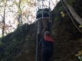
Careful! This route contains a few ladders and is therefore not suitable for people who are afraid of heights.
Itinerary:
The route starts in the village of Rochehaut, a car park is located at the panoramic viewpoint on the outskirts of the village.
The first part of the visit follows the main trail (GR14) and the hiking marker number 84. Once arrived at the Semois, we leave the main path and continue to follow the 84 which takes you to the ladders. Once you have survived the ladders, you will find yourself on a larger path that you follow on the left towards Poupehan, you can skip the side paths here until you reach above Poupehan and you descend on the left towards the center and the bridge over the Semois. Above the bridge is a cafeteria where you can recharge your batteries as the tour continues along a short but powerful climb to the slightly higher cross. The path passes over the crest of the hill and takes you to the hairpin bend of the N893. You cross this and follow the other paved road until you see a path on the left. You take this path and take the next one on the right (so not above the stream). The Frahan Crests are already marked here with wooden signs and the path also ends on the main path that you follow to Arahan. After crossing the center of the village, we head towards the Semois where we can enjoy a terrace before starting the climb to Rochehaut. We then cross the pedestrian bridge and turn left on the lowest path, in short we do not take the wide path to Rochehaut but go up a narrow path along the banks of the Semois. This less traveled path takes you along a very beautiful piece of nature and makes it even more difficult than a wide path. A little further in a bat cave where a slate quarry was still sheltered, we climb the hill on the right for a short but steep climb to Rochehaut from where we started.
Hai notato qualcosa su questo itinerario?Aggiungere un problema
Naviga nel percorso in...
![]() App RouteYou Aprire
App RouteYou Aprire
Vuoi smettere di vedere questo annuncio?
→ Upgrade ora
![]()
Attendi, la navigazione è in preparazione.
Ora puoi navigare. Buon divertimento in viaggio!
Elaborazione della richiesta non è riuscita. Si prega di riprovare.
Vuoi smettere di vedere questo annuncio?
→ Upgrade ora
![]()
Attendi, il tuo download è in preparazione.
Il tuo download è pronto. Buon divertimento in viaggio!
Elaborazione della richiesta non è riuscita. Si prega di riprovare.
Vuoi smettere di vedere questo annuncio?
→ Upgrade ora
![]()
Attendi, la tua stampa è in preparazione.
La tua stampa è pronta per il download. Buon divertimento in viaggio!
Elaborazione della richiesta non è riuscita. Si prega di riprovare.
<iframe src="https://plugin.routeyou.com/routeviewer/free/?language=it&params.route.id=2331420&params.language=en" width="100%" height="600" frameborder="0" allowfullscreen></iframe>
<p><a class="routeYou_embed" href="https://app.routeyou.com/en-be/route/view/2331420?utm_source=embed&utm_medium=article&utm_campaign=routeshare&navigation=external" title="The scales and ridges of Frahan - RouteYou" target="_blank"><img src="https://image.routeyou.com/embed/route/960x670/2331420-en@2x.png" style="width: 100%; height: auto;" alt="The scales and ridges of Frahan"></a></p>
Altri commenti:
Questa funzionalità è disponibile esclusivamente per gli abbonati a RouteYou PREMIUM.
Prova 1 mese gratis e scopri la differenza! Non prendiamo alcun dettaglio di pagamento e la tua prova termina automaticamente dopo un mese.
© 2006-2025 RouteYou - www.routeyou.com