Azure
AzureCourse of Flanders 2013-04-28: http://sport.be.msn.com/loopvanvlaanderen/2013/nl/
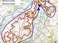
The starting and ending point is located on the Oudenaarde Market at an altitude of 11m.
This GPS routing was created based on the exact GPX recording with my GPS and some minor tweaks on the latest NGI digital topographic maps showing trails and terrain trails. The trail is not 50 km (officially) long but 51 km. And the altimeters to overcome are 930 meters for the whole loop.
Taking into account the added differences in NGI topographic height (about 930 meters), the walking distance (actual on slopes) is 51.18 km. See also the first POI at the start (Markt Oudenaarde) for these values and an image of the concrete height profile according to the loop to be travelled.
The trail consists largely of paved/paved/paved roads/paved strips, with also many forest trails and fields. The sloping rooms in the last part are mostly unpaved. The 51 km loop is therefore located in the heart of the Flemish Ardennes (with all known calf biters on the menu) and designed as part of the Trail.
Many exceptionally beautiful views can be admired during this loop.
Beyond the Scheldt at Oudenaarde, the following Flemish tracks are on the menu in order (some are traversed/walked along different flanks; each arrow shows a descent along a valley of a river):
--> Achterberg, Ladueze,
--> Eikenberg,
--> Bossenare (in part),
--> Koppenberg (1),
"> Onderbos,
--> Koppenberg (2),
--> Kwaremont (1),
"> Feelbos,
--> Kwaremont (2),
--> Paterberg (1),
--> Carillon-Chaux kiln near Paterberg (2),
--> Fonteinbos and Nophove,
--> (alongside Hoogberg),
--> Kabernol (Smisstraat),
--> Kortekeer (Nukerke),
--> Koppenberg (3).
The Flemish Ardennes at its best!
Hai notato qualcosa su questo itinerario?Aggiungere un problema
Naviga nel percorso in...
![]() App RouteYou Aprire
App RouteYou Aprire
Vuoi smettere di vedere questo annuncio?
→ Upgrade ora
![]()
Attendi, la navigazione è in preparazione.
Ora puoi navigare. Buon divertimento in viaggio!
Elaborazione della richiesta non è riuscita. Si prega di riprovare.
Vuoi smettere di vedere questo annuncio?
→ Upgrade ora
![]()
Attendi, il tuo download è in preparazione.
Il tuo download è pronto. Buon divertimento in viaggio!
Elaborazione della richiesta non è riuscita. Si prega di riprovare.
Vuoi smettere di vedere questo annuncio?
→ Upgrade ora
![]()
Attendi, la tua stampa è in preparazione.
La tua stampa è pronta per il download. Buon divertimento in viaggio!
Elaborazione della richiesta non è riuscita. Si prega di riprovare.
<iframe src="https://plugin.routeyou.com/routeviewer/free/?language=it&params.route.id=701042&params.language=en" width="100%" height="600" frameborder="0" allowfullscreen></iframe>
<p><a class="routeYou_embed" href="https://app.routeyou.com/en-be/route/view/701042?utm_source=embed&utm_medium=article&utm_campaign=routeshare&navigation=external" title="Promenade des Flandres (51km) - RouteYou" target="_blank"><img src="https://image.routeyou.com/embed/route/960x670/701042-en@2x.png" style="width: 100%; height: auto;" alt="Promenade des Flandres (51km)"></a></p>
Altri commenti:
Questa funzionalità è disponibile esclusivamente per gli abbonati a RouteYou PREMIUM.
Prova 1 mese gratis e scopri la differenza! Non prendiamo alcun dettaglio di pagamento e la tua prova termina automaticamente dopo un mese.
© 2006-2025 RouteYou - www.routeyou.com