Grazie al nostro partner De Wandelmaker, puoi accedere gratuitamente a questo itinerario e conoscere RouteYou PLUS.
Scopri tutti i vantaggi Azure
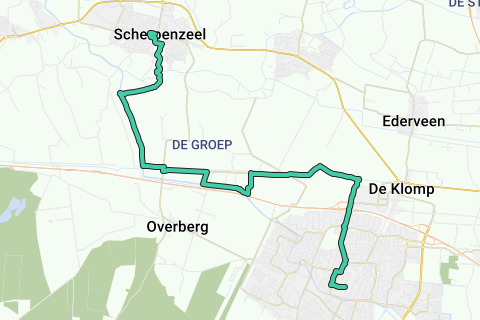
AzureFrom village to village - Scherpenzeel to Veenendaal
Hours going: 31/2
paved/unpaved: 60/40
Accessibility by public transport:
Scherpenzeel: Bus: stop Kerk
Veenendaal: Station Veenendaal Centrum
This route starts at the foot of the tower of the Grote Kerk of the Gelderland village Scherpenzeel and ends at its big cousin: the Utrechtse Veenendaal.
Turn the corner at the old town hall and you are face to face with Huize Scherpenzeel, formerly one whole with the estate of the same name. Once you have walked out of Scherpenzeel, the blue-white shutters of the Scherpenzeel Estate can still be seen on the farms on the left and right. The topper of this route is a grass path along, it seems, a forgotten piece of Valley Canal.
There is no cycle path along the canal here yet, so the walker has the empire alone and you can therefore enjoy, for example, the rustling of the reeds.
After the passage of the Utrecht-Arnhem railway line, we walk further along a forgotten part, but this time of the Grebbelinie: The 'Groeper Kade', which here formed a so-called second quay in the Grebbelinie.
For motorists who regularly travel on the A12 from Utrecht to Arnhem, it is a well-known beacon: 'The Emminkhuizerberg'. It's not a mountain; However, the hill of more than 20 meters high is never
wooded and therefore very visible and a striking appearance. This walk goes a bit of 'cross-country' along the foot of the 'mountain'.
The Fort on the Buursteeg that we then encounter is part of the Grebbelinie and is still subject to renovation. It has now been stripped of most vegetation so that its size and shape are clearly visible.
Once we have taken the A12 barrier, we walk into Veenendaal where we are greeted by windmill 'De Vriendschap'. Through one of the oldest streets of Veenendaal, 'De Achterkerkstraat' we finally arrive at The Market of Veenendaal.
Hai notato qualcosa su questo itinerario?Aggiungere un problema
Naviga nel percorso in...
![]() App RouteYou Aprire
App RouteYou Aprire
![]()
Attendi, la tua stampa è in preparazione.
La tua stampa è pronta per il download. Buon divertimento in viaggio!
Elaborazione della richiesta non è riuscita. Si prega di riprovare.
<iframe src="https://plugin.routeyou.com/routeviewer/free/?language=it&params.route.id=3542124&params.language=en" width="100%" height="600" frameborder="0" allowfullscreen></iframe>
<p><a class="routeYou_embed" href="https://app.routeyou.com/en-nl/route/view/3542124?utm_source=embed&utm_medium=article&utm_campaign=routeshare&navigation=external" title="Scherpenzeel - Veenendaal - RouteYou" target="_blank"><img src="https://image.routeyou.com/embed/route/960x670/3542124-en@2x.png" style="width: 100%; height: auto;" alt="Scherpenzeel - Veenendaal"></a></p>
Altri commenti:
Questa funzionalità è disponibile esclusivamente per gli abbonati a RouteYou PREMIUM.
Prova 1 mese gratis e scopri la differenza! Non prendiamo alcun dettaglio di pagamento e la tua prova termina automaticamente dopo un mese.
© 2006-2025 RouteYou - www.routeyou.com