2240 keer bekeken | Publiek | Duits • Frans • Nederlands
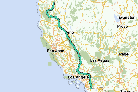
The Pacific Crest Trail (commonly abbreviated as the PCT, and occasionally designated as the Pacific Crest National Scenic Trail) is a long-distance hiking and equestrian trail closely aligned with the highest portion of the Sierra Nevada and Cascade mountain ranges, which lie 100 to 150 miles (160 to 240 km) east of the U.S. Pacific coast. The trail's southern terminus is on the U.S. border with Mexico, and its northern terminus on the U.S.Canada border on the edge of Manning Park in British Columbia, Canada; its corridor through the U.S. is in the states of California, Oregon, and Washington.
Inspired by OSM.
Iets opgevallen op deze route?Probleem toevoegen
Navigeer de route met...
![]() RouteYou app Open
RouteYou app Open
Deze advertentie niet meer zien?
→ Upgrade nu
![]()
Even geduld, de navigatie wordt voorbereid.
Je kan nu navigeren. Veel plezier onderweg!
Het verwerken van de aanvraag is mislukt. Gelieve het opnieuw te proberen.
Deze advertentie niet meer zien?
→ Upgrade nu
![]()
Even geduld, je download wordt voorbereid.
Je download is klaar. Veel plezier onderweg!
Het verwerken van de aanvraag is mislukt. Gelieve het opnieuw te proberen.
Deze advertentie niet meer zien?
→ Upgrade nu
![]()
Even geduld, je afdruk wordt voorbereid.
Je afdruk is klaar om te downloaden. Veel plezier onderweg!
Het verwerken van de aanvraag is mislukt. Gelieve het opnieuw te proberen.
<iframe src="https://plugin.routeyou.com/routeviewer/free/?language=nl&params.route.id=2060884&params.language=en" width="100%" height="600" frameborder="0" allowfullscreen></iframe>
<p><a class="routeYou_embed" href="https://app.routeyou.com/en-us/route/view/2060884?utm_source=embed&utm_medium=article&utm_campaign=routeshare&navigation=external" title="Pacific Crest Trail (south) - RouteYou" target="_blank"><img src="https://image.routeyou.com/embed/route/960x670/2060884-en@2x.png" style="width: 100%; height: auto;" alt="Pacific Crest Trail (south)"></a></p>
Bijkomende feedback:
Deze functionaliteit is exclusief beschikbaar voor RouteYou PREMIUM-abonnees.
Probeer nu 1 maand gratis en ontdek het verschil! We vragen geen betaalgegevens en het stopt automatisch na je proefperiode van een maand.
© 2006-2026 RouteYou - www.routeyou.com