31 Aufrufe | Öffentlich | Deutsch • Französisch • Niederländisch
Route description: Technically challenging, steep climbs and fast descents alternate with flatter sections. The route leads over single trails, forest and woodland paths, initially also directly into the Bike Fun Trails in the Eisenbachgrund. Signposting on site: MTB 7
Requirements: Difficult condition, medium riding technique
Condition of the route: 70% forest path, 20% trail, 10% asphalt
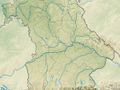
Course of the route: Starting point is the town hall in Schwarzenbach a.W.. From there towards the Schützenhaus. We leave the village behind us and the first singletrail awaits us, which is also the start of the BIKE FUN TRAILS (singletrail course). The single trail leads to the bottom of the "Eisenbach" valley; be careful: there are steps halfway down. From the Wasserhaus, a crisp trail up to the summit of the "Döbraberg", the highest mountain in the Franconian Forest, where you can enjoy a beautiful panoramic view from a lookout tower. The following steep descent takes us over the ski slope (freeride, single trail) to the mountain rescue hut and back to the "Eisenbachtal" on a wide forest path. Back at the Wasserhaus, this time we take the forest path for the next ascent. At the top, past a small quarry to Rodeck and then downhill to the "Bischofsmühle" (beautifully situated, with refreshments) to tackle the next small climb. After the next descent on gravel, a crisp ascent awaits, partly over rock, bumpy ground and meadow. Once you reach the top, you have the opportunity to stop for a bite to eat in Oberbrumberg. A short asphalt passage on a road with little traffic turns into a gravel descent, which briefly offers a view of the surrounding valley slopes. For a few kilometers, the tour follows the course of the "Eisenbachtal" again. The following ascent leads over partly loose rock through a hollow path ("Schloss Heinersreuth" junction). The ski slope is crossed and Elbersreuth is reached via the local road. We are then rewarded with a delightful singletrail descent that ends in Fels in the "Rodachtal". The following ascent is largely on gravel. Before reaching Bernstein a.W., it is worth stopping, turning around and enjoying the view. A beautiful descent from the "Galgenberg" is followed by a relatively flat ascent that "meanders" beautifully along the slope. As soon as we reach the top, the next trail/single trail awaits us. The same applies here as everywhere else: Watch out for hikers! In the immediate vicinity of the route is the "Viceburg", a hiking lodge. Gravel forest paths form the next ascent and take us to Meierhof. The last section offers a beautiful descent over a meadow trail, after which we pedal hard for a short time until the finish line beckons in Schwarzenbach a. W.
Special features & sights: Döbraberg (highest point in the Franconian Forest at 794 m) with the Prinz-Luitpold-Turm viewing tower, sculpture trail in Schwarzenbach am Wald, historic raft pond at the Bischofsmühle, Heinersreuth Castle, Romansfelsen near Bernstein am Wald
Ist Ihnen auf dieser Route etwas aufgefallen?Problem hinzufügen
Route navigieren in...
![]() RouteYou-App Öffnen
RouteYou-App Öffnen
Diese Werbung nicht mehr anzeigen?
→ Jetzt upgraden
![]()
Bitte warten Sie, die Navigation wird vorbereitet.
Sie können jetzt navigieren. Viel Routen-Spaß!
Bearbeitung Ihrer Anfrage ist fehlgeschlagen. Bitte versuchen Sie es erneut.
Diese Werbung nicht mehr anzeigen?
→ Jetzt upgraden
![]()
Bitte warten Sie, Ihr Download wird vorbereitet.
Ihr Download ist fertig. Viel Routen-Spaß!
Bearbeitung Ihrer Anfrage ist fehlgeschlagen. Bitte versuchen Sie es erneut.
Diese Werbung nicht mehr anzeigen?
→ Jetzt upgraden
![]()
Bitte warten Sie, Ihr Ausdruck wird vorbereitet.
Ihr Ausdruck ist bereit für den Download. Viel Routen-Spaß!
Bearbeitung Ihrer Anfrage ist fehlgeschlagen. Bitte versuchen Sie es erneut.
<iframe src="https://plugin.routeyou.com/routeviewer/free/?language=de&params.route.id=14130848&params.language=en" width="100%" height="600" frameborder="0" allowfullscreen></iframe>
<p><a class="routeYou_embed" href="https://app.routeyou.com/en-de/route/view/14130848?utm_source=embed&utm_medium=article&utm_campaign=routeshare&navigation=external" title="Mountainbike 7 Döbraberg - RouteYou" target="_blank"><img src="https://image.routeyou.com/embed/route/960x670/14130848-en@2x.png" style="width: 100%; height: auto;" alt="Mountainbike 7 Döbraberg"></a></p>
Zusätzliches Feedback:
Diese Funktion ist ausschließlich für RouteYou PREMIUM-Abonnenten verfügbar.
Testen Sie 1 Monat kostenlos und entdecken Sie den Unterschied! Wir erfassen keine Zahlungsdaten und Ihre Testversion endet automatisch nach einem Monat.
© 2006-2026 RouteYou - www.routeyou.com